Purcell, Oklahoma facts for kids
Quick facts for kids
Purcell, Oklahoma
|
|
|---|---|

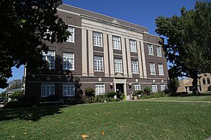
McClain County Courthouse in Purcell
|
|
| Nickname(s):
Heart of Oklahoma, Quarterhorse Capital of the World, Queen City of the Chickasaw Nation
|
|

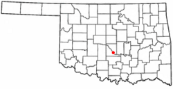
Location of Purcell, Oklahoma
|
|
| Country | United States |
| State | Oklahoma |
| Counties | McClain |
| Incorporated | 1898 |
| Government | |
| • Type | Council-Manager Charter |
| Area | |
| • Total | 15.73 sq mi (40.75 km2) |
| • Land | 15.20 sq mi (39.36 km2) |
| • Water | 0.53 sq mi (1.38 km2) |
| Elevation | 1,099 ft (335 m) |
| Population
(2020)
|
|
| • Total | 6,651 |
| • Density | 437.59/sq mi (168.96/km2) |
| Time zone | UTC-6 (Central (CST)) |
| • Summer (DST) | UTC-5 (CDT) |
| ZIP code |
73080
|
| Area code(s) | 405 |
| FIPS code | 40-61150 |
| GNIS feature ID | 1096963 |
Purcell is a city in McClain County, Oklahoma, United States. It is also the county seat, meaning it's where the county government is located. In 2020, about 6,651 people lived there. This was a 13% increase from 2010.
The city was started in 1887. It was a railroad town named after Edward B. Purcell. He was an important person at the Atchison, Topeka and Santa Fe Railway.
Purcell is often called the "Quarterhorse Capital of the World." This is because of its strong connection to the American Quarter Horse. Its official saying is "Heart of Oklahoma." The city has special rights to use both these names.
Contents
History of Purcell
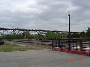
Purcell was at the northern end of the Gulf, Colorado and Santa Fe Railway. This railway was owned by the AT&SF company. Today, you can still take a train from Purcell. Amtrak's Heartland Flyer train stops at the station there.
Purcell was the only town right on the edge of the "Unassigned Lands." These were lands that had not yet been given to anyone. Many people wanted to settle there, even before the big Land Rush of 1889. Land lots in Purcell went on sale on April 5, 1887. A post office opened just 16 days later.
The Purcell Register newspaper started in 1887. It is the oldest newspaper in town and is still running today. The town's first mayor, James Taylor Bradley, was chosen on August 13, 1895. Purcell officially became a city on October 3, 1898.
The city is located on the Canadian River. It was once known as the "Queen City of the Chickasaw Nation." In 1895, one of the five main courts for the Chickasaw Nation was in Purcell. Its first court session began on November 18, 1895. The very next day, a fire destroyed most of the businesses downtown. Luckily, the courthouse was saved.
The Oklahoma Central Railroad (OCR) reached Purcell in March 1907. This railroad was built to connect coal mines in Lehigh with Chickasha. The OCR built its main yards and equipment storage in Purcell. The OCR company went out of business the next year. But its assets were bought by the AT&SF railway.
Geography and Location
Purcell is in the Great Plains region. It is located at 35°1′3″N 97°22′10″W / 35.01750°N 97.36944°W. The city covers about 27.2 square kilometers (10.5 square miles). Most of this is land, with a small part being water.
Purcell is along the I-35 Corridor in central Oklahoma. It sits on a high point overlooking the Canadian River valley. It is about 13 miles (21 km) south of Norman. From a spot called Red Hill in Purcell, you can see both the South Canadian River and the University of Oklahoma campus in Norman.
The main part of Purcell is where US-77 and OK-74/OK-39 roads meet. You can get to I-35 from the north and south ends of town. Before I-35 was built, US-77 was a very busy road connecting Oklahoma City to Dallas.
Population Changes Over Time
| Historical population | |||
|---|---|---|---|
| Census | Pop. | %± | |
| 1900 | 2,277 | — | |
| 1910 | 2,740 | 20.3% | |
| 1920 | 2,938 | 7.2% | |
| 1930 | 2,817 | −4.1% | |
| 1940 | 3,116 | 10.6% | |
| 1950 | 3,546 | 13.8% | |
| 1960 | 3,729 | 5.2% | |
| 1970 | 4,076 | 9.3% | |
| 1980 | 4,638 | 13.8% | |
| 1990 | 4,784 | 3.1% | |
| 2000 | 5,571 | 16.5% | |
| 2010 | 5,884 | 5.6% | |
| 2020 | 6,651 | 13.0% | |
| U.S. Decennial Census 2020 |
|||
In 2000, there were 5,571 people living in Purcell. There were 2,120 households. About 33.9% of these households had children under 18. Most households (54.1%) were married couples.
The average household had 2.54 people. The average family had 3.06 people. The population was spread out by age. About 26.9% were under 18. About 15.5% were 65 or older. The average age was 36 years.
The median income for a household was $33,283. For a family, it was $36,128. About 14.4% of the population lived below the poverty line. This included 19.9% of those under 18.
Economy and Jobs
Purcell is part of the Heart of Oklahoma Chamber of Commerce. It is a central place for trade in its area. This area includes nearby towns like Goldsby, Lexington, Washington, and Wayne.
Many small businesses and banks are in Purcell. There is also a Walmart Supercenter. Historically, Purcell has been important for farming and the horse industry in Oklahoma.
The largest employers in the area are the Oklahoma Department of Corrections. They have two nearby prison facilities. Other employers include Purcell Public Schools and the City of Purcell. The city provides electric, water, and sewer services.
Historic Places in Purcell
Purcell's downtown area has many old, important buildings. In the 1990s, over $1 million was spent to improve and restore them. This was part of the "U.S. Main Street" program. The improvements included new sidewalks, old-style lamp posts, and restored storefronts.
Purcell has four places listed on the National Register of Historic Places. This means they are important historical sites:
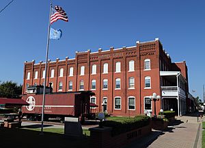
- Hotel Love: A three-story brick building from the Victorian era. It now has an antique store, a bed and breakfast, and offices.
- McClain County Courthouse: An old three-story brick building from the early 1900s. It was restored in 1995.
- James C. Nance Memorial Bridge: This bridge crosses the Canadian River. It connects Purcell to Lexington.
- United States Post Office Purcell: Located at 228 W Main St.
James C. Nance Memorial Bridge
The James C. Nance Memorial Bridge connects Purcell and Lexington. It crosses the Canadian River. The first bridge was built around 1938. In 2019, a new, wider bridge was built. It has four lanes. The bridge is named after James C. Nance. He was a newspaper publisher and a leader in Oklahoma government.
This bridge makes travel between Purcell and Lexington very fast. It takes only about 3 minutes by car. If the bridge were closed, the trip would take much longer. It would be 43 minutes if you went north to the next bridge. It would be over an hour if you went southeast.
The bridge helps trade and business flow easily between communities. The new 2019 bridge looks similar to the old one. It has concrete posts and old-style wrought iron railings. It also has a separate walkway for people to enjoy views of the river valley.
The new bridge opened on July 26, 2019. This was a big event for both Purcell and Lexington.
Education in Purcell
Purcell has modern school facilities. A new public high school campus was built in 2007–2008. It cost $14 million. The new junior high school has a storm shelter for both junior high and high school students. The elementary and intermediate schools are on North Ninth Street.
City Services and Recreation
Parks and Recreation
- Brent Bruehl Memorial Golf Course: This golf course is named after a talented Purcell High School golfer who passed away. It is located near Purcell Lake, along with the city's swimming pool.
- Veterans Memorial Park: This park is downtown, across from City Hall. It has granite memorials and nameplates. City workers, the local Rotary Club, and the American Legion helped build it.
Transportation in Purcell
Purcell's train station is on East Main Street. Amtrak's Heartland Flyer train stops there every day. You can travel north to Norman and Oklahoma City. You can also go south to Pauls Valley, Ardmore, and Fort Worth. In Fort Worth, you can connect to Amtrak's Texas Eagle.
Interstate 35 runs along the west side of Purcell. The town is also served by U.S. Highway 77, State Highway 39, and State Highway 74.
Purcell Municipal-Steven E. Shephard Field is the local airport. It has a paved runway over 3,000 feet long. The airport was renamed in 2005 to honor a Purcell High School graduate. He was a U.S. pilot who died in the Iraq War.
Media in Purcell
In 2016, Purcell got a license for a low-power FM radio station. It is called KQTR-LP and broadcasts on 93.9 FM. It plays a variety of music and shows.
| Call sign | Frequency | City of license | Facility ID | Class | ERP (W) |
Height (m (ft)) |
Transmitter coordinates |
|---|---|---|---|---|---|---|---|
| KQTR-LP | 93.9 FM | Purcell, Oklahoma | 193719 | LP1 | 45 | 45 m (148 ft) | 35°0′42.1″N 97°21′45.2″W / 35.011694°N 97.362556°W |
Famous People from Purcell
- Earl Bartlett: A professional football player.
- Lisa Johnson Billy: A member of the Oklahoma House of Representatives.
- Eric Buterbaugh: An American florist and perfumer.
- Wallace Fox: A film director.
- Lester Lane: Won a gold medal in the 1960 Summer Olympics.
- Tom Lester: An actor and former teacher in Purcell. He is best known for playing Eb Dawson on the TV show Green Acres.
- F. C. Love: President of the Kerr-McGee oil company.
- Bill McClard: A professional football player.
- James C. Nance: A newspaper publisher and former leader in Oklahoma government.
- Parker Millsap: An alt-country and blues musician.
- William T. Pheiffer: A Representative from New York and an ambassador.
- Joe Simpson: A professional baseball player.
- Bert Seabourn: An American artist and painter.
- Charles W. Wantland: A coach.
- Neil B. Ward: A meteorologist and storm chaser.
- David W. Whitlock: The 15th president of Oklahoma Baptist University.
See also
 In Spanish: Purcell (Oklahoma) para niños
 | Stephanie Wilson |
 | Charles Bolden |
 | Ronald McNair |
 | Frederick D. Gregory |


