
National Register of Historic Places listings in Grady County, Oklahoma facts for kids

Have you ever wondered about old buildings or places that have a special story? In the United States, there's a special list called the National Register of Historic Places. It's like a hall of fame for important buildings, sites, and objects that tell us about the past. When a place is on this list, it means it's worth protecting and preserving for future generations.
Grady County, located in Oklahoma, has several amazing places on this list. These sites help us understand the history of the county, from its early days to more recent times. They include old courthouses, schools, farms, and even entire neighborhoods! Let's explore some of these cool historic spots.
What is the National Register of Historic Places?
The National Register of Historic Places is the official list of the nation's historic places that are considered worthy of preservation. It's managed by the National Park Service, which is part of the United States government. Being on the list helps people understand why a place is important and can sometimes help protect it from being torn down or changed too much. It's all about saving history!
Historic Buildings in Chickasha
Many of Grady County's historic places are found in the city of Chickasha. This city has a rich past, and many of its buildings show what life was like long ago.
Chickasha Downtown Historic District
Imagine walking through a part of Chickasha where many buildings are old and have a unique style. That's the Chickasha Downtown Historic District! It includes many buildings built between 1900 and 1950. These buildings were once busy shops, offices, and theaters. They show how the city grew and changed over time.

Grady County Courthouse
The Grady County Courthouse is a grand building where important county decisions are made. It was built in 1913 and has a beautiful design. Courthouses are often central to a town's history, and this one is no different. It has seen many changes in the county over the years.

US Post Office and Federal Courthouse
Another important building in Chickasha is the US Post Office and Federal Courthouse. This building served as both a place to send mail and a court for federal cases. It was built in 1935 and is a great example of the architecture from that time.

Rock Island Depot
Train stations, or depots, were once very important for travel and trade. The Rock Island Depot in Chickasha was a busy place where people arrived and departed, and goods were shipped. It was built in 1910 and reminds us of the days when trains were the main way to get around.

New Hope Baptist Church
Churches are often central to a community's history and culture. The New Hope Baptist Church in Chickasha, built in 1910, is a significant landmark. It has served its community for over a century and holds many stories within its walls.

University of Science and Arts of Oklahoma
The University of Science and Arts of Oklahoma (USAO) is a historic college campus. The part of the campus on the National Register is known as the Oklahoma College for Women Historic District. This area includes several buildings that were part of the college when it was first established as a women's college in 1908. It shows the history of education in Oklahoma.

Other Historic Places in Grady County
Beyond Chickasha, Grady County has other unique historic sites that tell different parts of its story.
Knippelmeir Farmstead
The Knippelmeir Farmstead near Minco is a great example of an early 20th-century farm. It includes the farmhouse and other buildings that were part of a working farm. This site helps us understand what farm life was like in Oklahoma many years ago.

Minco Armory
An armory is a place where military equipment is stored, and where soldiers might train. The Minco Armory was built in 1936 and served as a training facility for the Oklahoma National Guard. It's an important piece of local military history.

Pocasset Gymnasium
The Pocasset Gymnasium is a historic school gym located near Pocasset. Built in 1936, it was a central part of community life, hosting school sports and other events. It represents the importance of schools and community gathering places in rural Oklahoma.

Verden Separate School
The Verden Separate School is a very important historic site. It was a school built in 1925 for African American children during a time when schools were segregated, meaning Black and white students attended separate schools. This building stands as a reminder of the challenges and changes in education history.

Images for kids
-
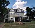
The Griffin House in Chickasha.

