National Register of Historic Places listings in Blaine County, Oklahoma facts for kids
This article is about the amazing historic places in Blaine County, Oklahoma, that are listed on the National Register of Historic Places. Think of this register as a special list of buildings, sites, or objects that are important to American history.
These places are officially recognized by the United States government because they tell a story about our past. They might be old homes, schools, bridges, or even special natural areas. By putting them on this list, we help make sure they are protected and remembered for future generations.
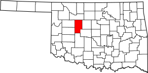
In Blaine County, there are 17 different properties that have earned a spot on this important list. Each one has a unique history and helps us understand what life was like long ago in Oklahoma. You can even see where some of these places are on a map if their exact location (latitude and longitude) is shared.
What is the National Register of Historic Places?
The National Register of Historic Places is the official list of the nation's historic places worth saving. It's like a hall of fame for important historical sites. When a place is added to this list, it means it has special meaning. This could be because of its age, its unique design, or a major event that happened there.
Being on the register helps protect these places. It also encourages people to learn about them and keep them in good condition. It's a way to celebrate and preserve the history of our country.
Why are these places important?
Historic places are like time capsules. They show us how people lived, worked, and built things in the past. They can teach us about different cultures, important events, and how our communities grew.
For example, an old courthouse might show us how laws were made. An old farm building could tell us about farming methods from long ago. By visiting or learning about these sites, we connect with history in a real way. They help us understand where we came from and how things have changed over time.
Historic Spots in Blaine County
Blaine County is home to many interesting places on the National Register. Each one has its own story. Here are some of the historic sites you can find here:
| Name on the Register | Image | Date listed | Location | City or town | Description | |
|---|---|---|---|---|---|---|
| 1 | Acre Family Barn |
(#13000073) |
Route 2, Box 37 36°02′21″N 98°36′09″W / 36.03917°N 98.60251°W |
Canton vicinity | This historic barn is a great example of early farm buildings in the area. | |
| 2 | Blaine County Courthouse |
(#84002972) |
N. Weigle St. 35°50′46″N 98°24′38″W / 35.846111°N 98.410556°W |
Watonga | The main building for county government, showing classic architecture. | |
| 3 | Cantonment |
(#70000527) |
North of Canton 36°06′00″N 98°37′02″W / 36.1°N 98.617222°W |
Canton | An important military post from the past, showing early settlement efforts. | |
| 4 | Jesse Chisholm Grave Site |
(#71000658) |
Northeast of Geary near the North Canadian River 35°43′36″N 98°17′28″W / 35.726667°N 98.291111°W |
Geary | The burial site of Jesse Chisholm, a famous trader and guide. | |
| 5 | Cronkhite Ranch House |
(#83002073) |
North of Watonga off State Highway 51A 35°56′11″N 98°27′11″W / 35.936389°N 98.453056°W |
Watonga | An old ranch house that tells the story of early ranching in Oklahoma. | |
| 6 | Thompson Benton Ferguson House |
(#73001555) |
521 N. Weigel St. 35°50′56″N 98°25′01″W / 35.848889°N 98.416944°W |
Watonga | The home of a former Oklahoma governor, showing historic residential architecture. | |
| 7 | Gillespie Building |
(#89001963) |
102 E. Main St. 35°37′51″N 98°19′01″W / 35.630833°N 98.316944°W |
Geary | An important commercial building from Geary's early days. | |
| 8 | Noble Hotel |
(#96000491) |
112 N. Noble St. 35°50′41″N 98°24′45″W / 35.844722°N 98.4125°W |
Watonga | A historic hotel that once welcomed travelers to Watonga. | |
| 9 | Okeene Flour Mill |
(#76001555) |
Off State Highway 51 36°07′02″N 98°19′12″W / 36.117222°N 98.32°W |
Okeene | An old flour mill, showing the importance of agriculture in the region. | |
| 10 | Old Plant Office Building, U.S. Gypsum Co. |
(#83002074) |
State Highway 51A 36°03′21″N 98°28′29″W / 36.055833°N 98.474722°W |
Southard | Part of an old gypsum mining operation, important to the local economy. | |
| 11 | Old Salt Works |
(#83002075) |
Southeast of Southard 36°01′03″N 98°27′11″W / 36.0175°N 98.453056°W |
Southard | A site where salt was once gathered, showing early industry. | |
| 12 | Public Water Trough |
(#89001965) |
Junction of Main, Canadian, and Northeast Boulevard 35°37′52″N 98°18′54″W / 35.631111°N 98.315°W |
Geary | A historic watering spot for animals in the town center. | |
| 13 | Shinn Family Barn |
(#83002076) |
Southeast of Okeene 36°05′08″N 98°14′35″W / 36.085556°N 98.243056°W |
Okeene | Another historic barn, showing the agricultural heritage of the area. | |
| 14 | Sooner Co-op Association Elevator (West) |
(#00001040) |
302 W. F St. 36°07′04″N 98°19′13″W / 36.117778°N 98.320278°W |
Okeene | A large grain elevator, important for storing crops. | |
| 15 | United States Post Office Watonga |
(#09000213) |
121 N. Noble Ave. 35°50′41″N 98°24′47″W / 35.844686°N 98.413125°W |
Watonga | The historic post office building, a key part of community life. | |
| 16 | J.H. Wagner House |
(#83002077) |
521 N. Prouty Ave. 35°50′59″N 98°24′51″W / 35.849722°N 98.414167°W |
Watonga | A historic home that shows the architectural styles of its time. | |
| 17 | Watonga Armory |
(#94000491) |
301 W. Main 35°50′39″N 98°24′56″W / 35.844167°N 98.415556°W |
Watonga | A building used by the military reserve forces, important for local defense history. |


