
National Register of Historic Places listings in Kingfisher County, Oklahoma facts for kids

Welcome to Kingfisher County, Oklahoma! This page is all about special places in the county that are listed on the National Register of Historic Places. Think of this register as a special list of buildings, sites, or objects that are important to American history.
These places are like time capsules, helping us remember the past and understand how people lived long ago. In Kingfisher County, there are 10 amazing spots that have earned a place on this important list. You can even see where some of them are located on a map if their exact coordinates are shared!
Contents
Exploring Kingfisher County's Historic Treasures
Kingfisher County is home to several buildings and sites that tell stories from the past. Let's take a look at some of these historic treasures.
Historic Grain Elevators
Grain elevators are tall buildings used to store grain like wheat or corn. They were very important for farmers in Oklahoma, helping them store their crops before sending them to market. Kingfisher County has a few of these historic structures:
- Burrus Mills Elevator C in Kingfisher: This elevator is a reminder of the county's farming history.
- Dow Grain Company Elevator in Okarche: Another important grain storage building.
- Farmers Co-op Elevator in Hennessey: This elevator also played a big role in the local farming community.
- Kiel-Dover Farmers Elevator in Dover: Located where E. Chestnut Street meets the railroad, this elevator was key for farmers in the Dover area.
Important Buildings in Kingfisher
The city of Kingfisher itself has several buildings that are part of the National Register:
- Kingfisher Armory: Found on North 6th Street, an armory is a place where military groups train or store equipment. This building has a history connected to local defense and community events.
- Kingfisher College Site: About a mile east of Kingfisher, this was once the location of Kingfisher College. Even if the buildings are no longer there, the site itself is recognized for its historical importance in education.
- Kingfisher Memorial Hall: Located on West Miles Avenue, this hall likely served as a gathering place for the community and might honor local heroes or events.
- Kingfisher Post Office: At the corner of Main and Robberts Streets, this post office building has been a central part of communication for the town for many years.
- Seay Mansion: On 11th Street and Zellers Avenue, this grand house is a significant piece of Kingfisher's architectural history. It was once the home of Abraham Jefferson Seay, an early governor of Oklahoma Territory.
Other Notable Buildings
- Farmers and Merchants National Bank in Hennessey: This old bank building on South Main Street shows us what financial institutions looked like in the past and how they served the community.
What is the National Register of Historic Places?
The National Register of Historic Places is the official list of the nation's historic places worth saving. It's managed by the National Park Service in the United States Department of the Interior. When a place is added to this list, it means it's recognized as important to the history, architecture, archaeology, engineering, or culture of the United States.
Being on the Register helps to:
- Recognize and celebrate a place's historical importance.
- Encourage people to preserve and protect these special sites.
- Sometimes, it can help property owners get grants or tax benefits to help take care of their historic buildings.
Why are These Places Important?
These historic places in Kingfisher County are more than just old buildings. They are like clues that help us understand the past. They show us:
- How people lived and worked in earlier times.
- The types of buildings they built.
- The challenges and successes they faced.
- The history of farming, education, and community life in Oklahoma.
By preserving these sites, we make sure that future generations can also learn from and appreciate the rich history of Kingfisher County and Oklahoma.
Images for kids
-
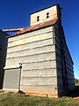
The Dow Grain Company Elevator in Okarche, a historic grain storage building.

