
National Register of Historic Places listings in Texas County, Oklahoma facts for kids

Have you ever wondered about really old buildings or places that tell a story about the past? In Texas County, Oklahoma, there are many special spots that are listed on the National Register of Historic Places. This is like a special list kept by the United States government. It helps protect important buildings, sites, and objects so people can learn from them for many years to come.
When a place is on this list, it means it has a lot of history. It might be a very old house, a unique barn, or even a spot where ancient people used to live. Texas County has 24 of these amazing places. One of them is even more special and is called a National Historic Landmark! This means it's super important to the history of the whole country. Let's explore some of these cool historic places!
Contents
Historic Places in Texas County
Old Grain Elevators
Texas County is known for farming, especially growing grain. Because of this, many old woodframe grain elevators are on the historic list. These tall buildings were used to store grain after it was harvested. They were very important for farmers in the past.
- Adams Woodframe Grain Elevator: You can find this old elevator north of Oklahoma State Highway 3 in Adams, Oklahoma. It was added to the list in 1983.
- Baker Woodframe Elevator and Baker Woodframe Grain Elevator: Both of these are in Baker, Oklahoma. One is on SR 2847, and the other is off U.S. Route 64. They were both listed in 1983.
- Eva Woodframe Grain Elevator: This one is located on Oklahoma State Highway 95 in Eva, Oklahoma. It also joined the list in 1983.
- Hooker Woodframe Grain Elevator: You can see this elevator off Texas Avenue in Hooker, Oklahoma. It became historic in 1983.
- Hough Woodframe Elevator: This elevator is on Oklahoma State Highway 95 in Hough, Oklahoma. It was listed in 1983.
- Mouser Grain Elevator and Mouser Woodframe Grain Elevator/Collingwood Elevator: Both of these are near Oklahoma State Highway 136 in Mouser, Oklahoma. They were added in 1983.
- Optima Grain Elevator: This elevator is on U.S. Route 54 in Optima, Oklahoma. It was listed in 1983.
- Tracey Woodframe Grain Elevator: Located north of U.S. Route 64 in Muncy, Oklahoma, this elevator was also added in 1983.
Special Buildings and Homes
Besides grain elevators, other buildings in Texas County have important stories.
- Elmer Baker Barn: This unique barn is on Mile 47 Road in Hooker, Oklahoma. It was added to the list more recently, in 2012.
- CCC Ranch Headquarters: This historic ranch headquarters is west of Texhoma, Oklahoma. It was listed in 1983.
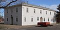
- Danholt: This building is located at 1208 N. May in Guymon, Oklahoma. It became a historic place in 2013.
- Franklin Hall: You can find Franklin Hall at 201 N. College Avenue in Goodwell, Oklahoma. It's part of a college campus and was listed in 2007.
- Hotel Dale: This old hotel is at 118 NW. 6th Street in Guymon, Oklahoma. It was added to the list in 2016.
- Penick House: This historic house is at 218 N. East Street in Texhoma, Oklahoma. It was listed in 1984.
- Texas County Courthouse: The main courthouse for Texas County is at 319 N. Main Street in Guymon, Oklahoma. It's an important building for the county's government and was listed in 1984.
Ancient Archeological Sites
Some of the most fascinating places on the list are archeological sites. These are spots where scientists have found clues about people who lived a very long time ago. Because these sites are so delicate and important, their exact locations are kept secret to protect them.
- Easterwood Archeological Site: This site is near Guymon, Oklahoma. It was listed in 1978.
- Johnson-Cline Archeological Site: This site is located near Texhoma, Oklahoma. It was added in 1978.
- Nash II-Clawson Archeological Site: Another site near Guymon, Oklahoma, listed in 1978.
- Old Hardesty: This site is near Hardesty, Oklahoma. It was listed in 1974.
- Shores Archeological Site: This site is near Eva, Oklahoma. It was added in 1978.
- Stamper Site: This very important site is near Optima, Oklahoma. It's so special that it's a National Historic Landmark, meaning it's one of the most important historic places in the entire country! It was listed way back in 1966.
- Two Sisters Archeological Site: This site is also near Guymon, Oklahoma. It was listed in 1978.
These historic places help us understand the rich history of Texas County, from its early farming days to the ancient people who once called this land home.
Images for kids
-
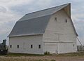
The Elmer Baker Barn in Hooker, Oklahoma.
-

The historic Danholt building in Guymon.
-
Franklin Hall at Oklahoma Panhandle State University in Goodwell.
-
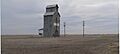
The Hooker Woodframe Grain Elevator.
-
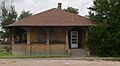
The Penick House in Texhoma.
-
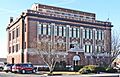
The Texas County Courthouse in Guymon.

_from_E_1.JPG)
_from_S_1.JPG)

_from_E_1.JPG)

