
National Register of Historic Places listings in Caddo County, Oklahoma facts for kids
Caddo County, Oklahoma, is home to many interesting places that are part of the National Register of Historic Places. This special list includes buildings, sites, and objects that are important to the history of the United States. Think of it as a way to protect and celebrate places that tell a story about the past.
In Caddo County, there are 14 such places. They range from old banks and stores to historic parks and even ancient archaeological sites. These places help us understand what life was like long ago and how the area has changed over time. By being on this list, these sites get special recognition and sometimes help with their care.

Contents
What is the National Register of Historic Places?
The National Register of Historic Places is the official list of the nation's historic places worth saving. It's like a hall of fame for buildings, structures, objects, sites, and districts that are important in American history, architecture, archaeology, engineering, and culture. When a place is added to this list, it means it has a special story to tell.
It helps people learn about the past and makes sure these important places are protected for future generations. Many of these sites are still used today, while others are preserved as museums or historical markers.
Historic Places in Caddo County
Let's explore some of the cool historic places you can find in Caddo County!
Buildings and Downtown Areas
Many historic buildings in Caddo County show us what towns looked like in the past.
Amphlett Brothers Drug and Jewelry Store
This old store, located in Apache, was added to the list in 1982. It was once a place where people could buy medicine and jewelry. Imagine what it was like to shop there many years ago!

Anadarko Armory
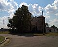
The Anadarko Armory in Anadarko was built in 1994. An armory is a building where military equipment is stored, and sometimes where soldiers train. This one has a unique history in the town.

Anadarko Downtown Historic District
This whole area in downtown Anadarko is considered historic. It includes many buildings that show the town's growth and development. Walking through it is like taking a step back in time. It was listed in 1990.

Apache State Bank
Also in Apache, the Apache State Bank was listed in 1972. Old bank buildings often have interesting architecture. They remind us of how important banks were to communities in the past.

First Baptist Church (Colored)
This church in Anadarko was added to the list in 2007. Churches often play a big role in a community's history and culture. This building holds many stories from its past.

Provine Service Station
Located near Hydro, this old service station was listed in 1997. Before big gas stations, smaller service stations like this were common. They were important stops for travelers on the road.
Historic Roads and Sites
Some historic places are not just buildings, but also parts of old roads or important natural sites.
Bridgeport Hill-Hydro OK 66 Segment
This section of State Highway 66 near Hydro is part of the famous Route 66. Route 66 was a very important road for travel across America. This part was listed in 2004 and extends into Canadian County.
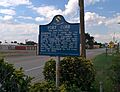
Fort Cobb Site
Near Fort Cobb, this site was listed in 1973. It's where an old military fort once stood. Forts were important for protecting settlers and controlling territories in early American history.

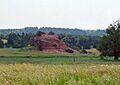
Rock Mary
This unique rock formation, located west of Hinton, was listed in 1970. Natural landmarks like Rock Mary were often important guideposts for early travelers and explorers.

Parks and Archeological Sites
Caddo County also has historic parks and places where ancient history can be found.
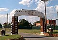
Randlett Park
This park in Anadarko was listed in 2003. Parks are important for community life and recreation. Historic parks often have unique designs or features from when they were first created.

Caddo County Medicine Creek Archeological District
This area near Binger is an archaeological district, listed in 1995. This means it contains important clues about ancient cultures and people who lived there long ago. Archaeologists study these sites to learn about the past. The exact location is kept private to protect the site.
Stevens Rock Shelter
Near Gracemont, this rock shelter was listed in 1995. Rock shelters are natural overhangs that were often used by early humans for protection. They can hold valuable archaeological information. Its exact location is also kept private for protection.
Former Listing
Sometimes, a place is removed from the National Register. This can happen if it is moved, destroyed, or no longer meets the requirements.
Black Beaver's Grave
Black Beaver's Grave, located north of Anadarko, was listed in 1973 but removed in 1975. This was because the grave was moved to Fort Hill cemetery. Black Beaver was a famous Delaware scout and guide.
Images for kids
-
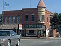
The historic Amphlett Brothers Drug and Jewelry Store.
-
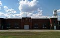
The Anadarko Armory building.
-
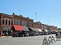
A view of downtown Anadarko.
-
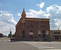
The old Apache State Bank building.
-
The First Baptist Church in Anadarko.
-
A historical marker at the Fort Cobb Site.
-
A view of Randlett Park.
-
The Rock Mary landmark.
