
National Register of Historic Places listings in Tulsa County, Oklahoma facts for kids

Welcome to Tulsa County, Oklahoma! Did you know that this area is home to many amazing old buildings and places? These special spots are so important that they are listed on the National Register of Historic Places. This list helps protect and celebrate the history of the United States.
In Tulsa County, there are 104 places on this list. One of them is even a super important spot called a National Historic Landmark! Let's explore some of these cool historic places and learn why they are so special.
Contents
What is the National Register of Historic Places?
The National Register of Historic Places is like a special club for buildings, sites, and objects that are important to American history. When a place is added to this list, it means it has a unique story to tell about our past. This could be because of its amazing design, a famous person who lived there, or an important event that happened there.
Being on the National Register helps protect these places. It encourages people to take care of them so future generations can enjoy and learn from them too. It's a way to keep history alive!
Cool Historic Places in Tulsa
Tulsa, a big city in Tulsa County, has many buildings on the National Register. These places show how the city grew and changed over time, especially during the oil boom!
Famous Buildings You Can See
Many of Tulsa's downtown buildings are on the list. They often have cool designs from the early 1900s.
- Ambassador Hotel: This beautiful hotel was built in 1929. It's a great example of the fancy buildings from that time.
- Atlas Life Building: Look up at this building! It has a giant neon sign that lights up the Tulsa skyline at night. It was built in 1922.
- Boston Avenue Methodist Church: This church is a National Historic Landmark! It's famous for its unique and tall design, called Art Deco, which was popular in the 1920s. It looks like something out of a futuristic movie!
- Mid-Continent Tower: Originally called the Cosden Building, this skyscraper was built in 1918. It was one of the tallest buildings in Oklahoma for a while!
- Mayo Hotel: Once a very fancy hotel, the Mayo Hotel hosted many famous people. It was built in 1925 and is a grand example of Tulsa's past.
- Philtower Building: This building, finished in 1928, is another stunning example of Art Deco architecture in Tulsa. It's known for its detailed decorations.
- Public Service of Oklahoma Building: Built in 1929, this building shows the power of electricity and industry in Tulsa's growth.


Historic Neighborhoods and Districts
Some entire areas, not just single buildings, are listed as "Historic Districts." This means a whole neighborhood has special historical importance.
- Blue Dome Historic District: This area used to be a busy spot along the famous Route 66. It's named after a unique blue-domed gas station.
- Brady Heights Historic District: This neighborhood has many beautiful old homes, showing how Tulsa's wealthy citizens lived in the early 1900s.
- Oil Capital Historic District: This large district in downtown Tulsa includes many of the city's most important buildings from the oil boom era. It shows how oil made Tulsa a rich and powerful city.
- Maple Ridge Historic Residential District: This is one of Tulsa's oldest and most beautiful neighborhoods, with many grand homes built in the early 20th century.
- Swan Lake Historic District: This charming neighborhood is centered around a small lake. It features many different styles of homes from the 1920s and 30s.
- Whittier Square Historic District: Another area along Route 66, this district has a mix of shops and homes that tell the story of early roadside businesses.


Places Connected to Route 66
The famous Route 66, also known as the "Mother Road," passed right through Tulsa. Several places connected to this historic highway are on the list.
- Casa Loma Hotel: This hotel was a popular stop for travelers on Route 66.
- Cities Service Station #8: An old gas station that served travelers on Route 66. It shows what roadside stops looked like in the past.
- Eleventh Street Arkansas River Bridge: This bridge was once part of Route 66, carrying cars over the Arkansas River.
- Sinclair Service Station: Another old gas station that reminds us of the golden age of car travel on Route 66.


Other Interesting Sites
Beyond the downtown area and Route 66, Tulsa County has other unique historic places.
- Broken Arrow Elementary-Junior High School: This old school building in Broken Arrow shows the history of education in the area.
- Cain's Ballroom: This famous music venue has hosted countless legendary musicians. It started as a dance academy in the 1920s.
- Creek Council Oak Tree: This ancient tree is a very important historical site for the Creek Nation. It's where leaders gathered to make important decisions.
- Dawson School: An important school building that served the community of Dawson.
- Hooper Brothers Coffee Company Building: This building was once a coffee company, showing the types of businesses that thrived in early Tulsa.
- Mount Zion Baptist Church: This church is a significant landmark, especially for its role in the history of Tulsa's African American community.
- Phillips 66 Station No. 473: Another example of a classic gas station from the past.
- Waite Phillips Mansion: This grand mansion was the home of Waite Phillips, a famous oil businessman. It's now part of the Philbrook Museum of Art.
- William G. Skelly House: The home of another important oilman, William G. Skelly, who played a big part in Tulsa's oil industry.
- Will Rogers High School: Named after the famous Oklahoman Will Rogers, this school is known for its beautiful Art Deco architecture.
- Woodward Park and Gardens Historic District: A beautiful park and garden area that has been a beloved spot in Tulsa for many years.


These are just a few of the many amazing historic places in Tulsa County. Each one has a story that helps us understand the rich history of Oklahoma!
Images for kids
-
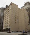
The Petroleum Building.
-
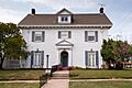
The James Alexander Veasey House.
-
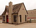
The Vickery Phillips 66 Station.
-
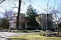
Westhope, a unique home in Tulsa.


