
National Register of Historic Places listings in Harper County, Oklahoma facts for kids

Welcome to Harper County, Oklahoma! This page is all about the special places in Harper County that are listed on the National Register of Historic Places. These are important buildings, sites, and areas that the United States government recognizes as worth protecting because of their history.
There are 17 different places in Harper County that have made it onto this important list. You can find out more about each one below. Some of these places are still standing, while others are archaeological sites that tell us about people who lived here long ago.
Historic Places in Harper County
Exploring Harper County's Past
Harper County, Oklahoma, is home to many interesting historical sites. These places help us understand what life was like in the past. From old buildings to ancient campsites, each spot has a unique story to tell.
Ancient Sites and Early Life
Some of the oldest places on the list are archaeological sites. These are spots where scientists have found clues about early people.
- The Beagley-Stinson Archeological Site is one such place. It was added to the list in 1978.
- Another important site is the Cooper Bison Kill Site. This site, listed in 2002, shows where ancient people hunted bison. It gives us a peek into how they lived and found food.
- The Patsy's Island Site and Smith No. 2 Site, both listed in 2004, are also archaeological areas that help us learn about the past.
Buildings and Structures from the Past
Many of the listed places are buildings or structures that were important to the communities.
- The Buffalo City Park Pavilion was built on U.S. Route 64 in Buffalo. It was added to the list in 1988. This pavilion likely served as a gathering spot for the community.
- The Clover Hotel in Laverne, located on Main Street and Oklahoma Avenue, became a historic place in 1984. Hotels were very important for travelers in the past.
- The Farmers' Co-op Elevator and Feuquay Elevator in Buffalo were listed in 1983. Grain elevators are tall buildings used to store grain. They show how important farming was to the area.
- The Fox Hotel in Laverne, on Broadway and NE 1st Street, was recognized in 1978. Like the Clover Hotel, it played a role in welcoming visitors.
- The Harper County Courthouse in Buffalo is a very important building. It's where local government decisions are made. This courthouse, located on Elm, Maple, 1st, and 2nd Streets, was listed in 1984.
- The I.O.O.F. Building of Buffalo is another historic structure. The I.O.O.F. stands for the Independent Order of Odd Fellows, a fraternal organization. This building on W. Turner Street was listed in 1983.
- The M. K. and T. Depot in Laverne was a train station. Train depots were vital for travel and trade. This depot on Main Street was listed in 1984.
- The Monhollow Artificial Stone House near Buffalo was listed in 1983. It's special because of how it was built.
- The Page Soddy is a unique type of home. A "soddy" is a house built from sod, or chunks of grass and soil. This one, southeast of Buffalo, was listed in 1983. It shows how early settlers built homes with the materials they had.
- The Sharp Lumberyard in Laverne, at 124 N. Broadway, was listed in 1984. Lumberyards were essential for providing building materials for a growing town.
Historic Districts and Waterways
Sometimes, a whole area or a special waterway can be listed as historic.
- Laverne's North Main Street District is an example of a historic district. This area, including Main Street and Broadway, was recognized in 1984. It means that many buildings in this part of town are historically important together.
- The Old Settler's Irrigation Ditch is a historic waterway. Located north of Rosston, this ditch was listed in 1983. Irrigation ditches were crucial for bringing water to farms in dry areas.
Images for kids
-
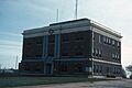
The Harper County Courthouse in Buffalo, Oklahoma.

