
National Register of Historic Places listings in Pushmataha County, Oklahoma facts for kids

Have you ever wondered about old buildings and places that are super important to history? In Pushmataha County, Oklahoma, there are some really special spots that are listed on the National Register of Historic Places. This is like a special list kept by the United States government to protect and celebrate places that tell us about the past.
These places are important because they show us how people lived, worked, and built things a long time ago. They help us understand the history of Oklahoma and the whole country. There are 8 amazing places in Pushmataha County that have made it onto this important list!
Contents
What is the National Register of Historic Places?
The National Register of Historic Places is the official list of places in the United States that are worth saving. These can be buildings, structures, objects, sites, or even whole districts. To get on the list, a place must be important in American history, architecture, archaeology, engineering, or culture.
When a place is added to the Register, it means it's recognized for its special value. This helps protect it and makes people more aware of its history. It's a way to make sure these important parts of our past are around for future generations to learn from and enjoy.
Exploring Pushmataha's Historic Treasures
Let's take a look at some of the cool historic places you can find in Pushmataha County. Each one has a unique story to tell!
Albion State Bank
The Albion State Bank building is located in the town of Albion. It was added to the National Register on December 11, 1979. This old bank building reminds us of how towns grew and how people did business many years ago. It's a piece of local history that shows what life was like in the early days of the county.
Antlers Frisco Depot and Antlers Spring
In the town of Antlers, you'll find the Antlers Frisco Depot and Antlers Spring. This spot was added to the Register on June 27, 1980. The depot was a train station, which was a very important place for travel and trade before cars were common. The spring nearby might have been a source of water for travelers or the town.

James Martin Baggs Log Barn
Near Pickens, there's the James Martin Baggs Log Barn. This barn was recognized on September 8, 2015. Log barns are a type of building that shows how early settlers built structures using materials they found around them. This barn helps us imagine what farming and daily life were like for families in the past.
Clayton High School-Auditorium
The Clayton High School-Auditorium is located in Clayton. It was added to the National Register on September 8, 1988. This building was once a busy place where students learned and where the community gathered for events. It's a reminder of the importance of education and community life in the county's history.

Fewell School
The Fewell School is found off State Highway 144 near Nashoba. It joined the Register on September 8, 1988. Like the Clayton High School, this old schoolhouse tells a story about how children were educated in rural areas. These buildings often served as important centers for their small communities.
Mato Kosyk House
East of Albion, off U.S. Route 271, is the Mato Kosyk House. This house was listed on December 11, 1979. It's named after Mato Kosyk, a famous Sorbian poet who lived there. This house is special because it connects Pushmataha County to international history and the story of immigrants who came to America.
Snow School
The Snow School is located on U.S. Route 271 in Snow. It was added to the National Register on September 8, 1988. This is another example of a historic school building that played a big role in the lives of children and families in the area. It shows how communities valued learning and built places for it.
Tuskahoma
The site of Tuskahoma is located about 2 miles north of the modern town of Tuskahoma. It was listed on July 28, 1970. This place is very important because it was once the capital of the Choctaw Nation. It's a significant historical site for understanding the history of Native American tribes in Oklahoma.
Images for kids
-
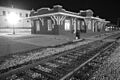
The old train depot in Antlers, Oklahoma.
-
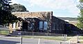
The historic high school auditorium in Clayton, Oklahoma.
