Tuskahoma, Oklahoma facts for kids
Quick facts for kids
Tuskahoma
Tushka Homma (Choctaw)
|
|
|---|---|

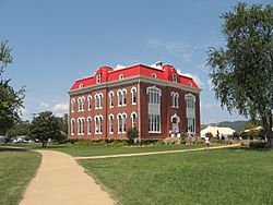
Choctaw Capitol Building in Tuskahoma, Oklahoma, September 22, 2009
|
|
| Motto(s):
The Red Warrior
|
|
| Country | United States |
| State | Oklahoma |
| County | Pushmataha |
| Area | |
| • Total | 2.29 sq mi (5.92 km2) |
| • Land | 2.26 sq mi (5.86 km2) |
| • Water | 0.03 sq mi (0.07 km2) |
| Elevation | 659 ft (201 m) |
| Population
(2020)
|
|
| • Total | 102 |
| • Density | 45.09/sq mi (17.41/km2) |
| Time zone | UTC-6 (Central (CST)) |
| • Summer (DST) | UTC-5 (CDT) |
| ZIP codes |
74574
|
| FIPS code | 40-75300 |
| GNIS feature ID | 2629939 |
Tuskahoma is a small community in Oklahoma, United States. It is located in northern Pushmataha County, about four miles east of Clayton. Tuskahoma was once the main center for the Choctaw Nation government before Oklahoma became a state. In 2020, 102 people lived there.
Contents
History of Tuskahoma
A United States Post Office first opened in Tuskahoma on February 27, 1885. Back then, it was called Tushka Homma. The spelling changed a few times over the years. It became Tushkahomma in 1891, and then Tuskahoma in 1910.
Meaning of the Name Tuskahoma
The name Tuskahoma comes from the Choctaw language. It means 'red warrior'. An old dictionary from 1852 spelled it Tvshka Homma. The "v" in that spelling is actually a Greek letter. It makes a short "u" sound. Today, the Choctaw Nation uses this older spelling in their official writings.
Tuskahoma as the Choctaw Nation Capital
Tuskahoma became the official capital of the Choctaw Nation in 1882. Before this, the Choctaw people had other capitals after their forced move on the Trail of Tears. Their first capital was at Nanih Waiyah, which was named after a sacred mound in Mississippi. This mound was a special place where the Choctaw people honored their ancestors.
The Choctaw Nation built a large, impressive building in Tuskahoma to be their government center. This Choctaw Capitol Building was finished in 1884. It was a two-story brick building with a fancy roof. Many people thought it was the best building in the Indian Territory. Inside, it had big rooms for the Senate, House of Representatives, and Supreme Court. It also had offices for the Principal Chief (like a governor) and other important leaders.
Impact of the Railroad on Tuskahoma
After the capitol building was finished, a busy town grew up around it. There were hotels, shops, and homes. But then, a new railroad was built in the mid-1880s. The St. Louis and San Francisco Railway tracks ran about two miles south of the capitol.
Because of the railroad, businesses moved closer to the new Tuskahoma train station. The area around the capitol building became quiet, except when the government was meeting. Even though the Choctaw constitution said leaders should live near the capital, this rule was not always followed.
Education in Tuskahoma
Tuskahoma was also meant to be a center for culture and learning. The Choctaw Nation opened a national girls' school there in 1892. It was called the Tuskahoma Female Academy. The school had a beautiful two-story building. Sadly, it burned down in 1925 and was never rebuilt. After that, Tuskahoma stopped being a major place for education.
The new town site near the railroad grew and became a busy trading center. It had banks, hotels, stores, churches, and a school. But over time, its importance lessened. This happened as new highways were built and people started using cars and trucks more than trains.
Geography of Tuskahoma
Getting around Tuskahoma changed a lot in the 1950s. That's when U.S. Highway 271 was built. This paved highway made it much easier to travel to nearby towns like Clayton, Antlers, and Talihina.
The Kiamichi River flows near Tuskahoma. It's a source of water, but it's not deep enough for boats. The river did play a role in where the train station was built. Trains needed a reliable water supply, which the river provided at the current town location.
Mountains and Hills Around Tuskahoma
The Kiamichi Mountains are a big part of the landscape around Tuskahoma. This area is known for its beautiful scenery in Oklahoma. The Kiamichi River valley stretches out to the east and west.
To the north, you can see the unique Potato Hills. These hills have jagged peaks that reach about 1,000 feet high. To the south, there are tall mountains that are about 1,600 feet high. This area is mostly wilderness, with few roads. People often use special timber company roads to get around there.
Unique Geological Features
The Tuskahoma region has many interesting rock formations. The valley itself is very pretty. The Potato Hills are a famous landmark. They are tall rock formations that were shaped by erosion from ancient mountains.
North of Tuskahoma are the McKinley Rocks. These are huge white boulders scattered on top of a mountain. It's hard to get to them, but from the rocks, you can see for miles. They were named after William McKinley, who was the 26th President of the United States.
Demographics
| Historical population | |||
|---|---|---|---|
| Census | Pop. | %± | |
| 2020 | 102 | — | |
| U.S. Decennial Census | |||
Choctaw Nation Labor Day Festival
The Choctaw Nation of Oklahoma hosts its yearly Labor Day Festival in Tuskahoma. This big event takes place on the grounds of the historic Capitol building. Many people, sometimes up to 100,000, come from all over the United States to attend.
The festival is packed with fun activities. You can enjoy country and gospel music concerts. There are also softball and basketball games, strength contests, and a carnival. Visitors can see animal shows, go on bison tours, and play horseshoe or volleyball games. The festival also has a swimming pool, playgrounds, and a museum. Many people camp in tents or RVs. There's even a 5K run!
The Choctaw Capitol Building is a very important part of the festival. It is recognized as a special historical building. It is listed on the National Register of Historic Places listings in Pushmataha County, Oklahoma. The building is the main attraction for all the Labor Day festivities.
Climate
| Climate data for Tuskahoma, Oklahoma. (Elevation 600ft) | |||||||||||||
|---|---|---|---|---|---|---|---|---|---|---|---|---|---|
| Month | Jan | Feb | Mar | Apr | May | Jun | Jul | Aug | Sep | Oct | Nov | Dec | Year |
| Record high °F (°C) | 78 (26) |
87 (31) |
93 (34) |
96 (36) |
97 (36) |
107 (42) |
112 (44) |
114 (46) |
112 (44) |
101 (38) |
87 (31) |
80 (27) |
114 (46) |
| Mean daily maximum °F (°C) | 53.1 (11.7) |
58.2 (14.6) |
67.2 (19.6) |
75.2 (24.0) |
81.3 (27.4) |
88.7 (31.5) |
94.6 (34.8) |
95.0 (35.0) |
87.3 (30.7) |
77.0 (25.0) |
64.4 (18.0) |
55.0 (12.8) |
74.8 (23.8) |
| Mean daily minimum °F (°C) | 29.1 (−1.6) |
33.1 (0.6) |
41.7 (5.4) |
49.7 (9.8) |
58.5 (14.7) |
66.5 (19.2) |
70.1 (21.2) |
69.1 (20.6) |
61.9 (16.6) |
50.5 (10.3) |
40.7 (4.8) |
31.7 (−0.2) |
50.2 (10.1) |
| Record low °F (°C) | −13 (−25) |
−4 (−20) |
5 (−15) |
21 (−6) |
32 (0) |
40 (4) |
47 (8) |
47 (8) |
32 (0) |
18 (−8) |
7 (−14) |
−10 (−23) |
−13 (−25) |
| Average precipitation inches (mm) | 2.94 (75) |
2.97 (75) |
3.68 (93) |
5.10 (130) |
5.95 (151) |
4.89 (124) |
3.38 (86) |
2.92 (74) |
4.40 (112) |
4.45 (113) |
4.02 (102) |
3.32 (84) |
48.02 (1,220) |
| Average snowfall inches (cm) | 1.7 (4.3) |
1.3 (3.3) |
0.4 (1.0) |
0 (0) |
0 (0) |
0 (0) |
0 (0) |
0 (0) |
0 (0) |
0 (0) |
0.1 (0.25) |
0.4 (1.0) |
4.0 (10) |
| Source: The Western Regional Climate Center | |||||||||||||
See also
 In Spanish: Tuskahoma (Oklahoma) para niños
 | Jessica Watkins |
 | Robert Henry Lawrence Jr. |
 | Mae Jemison |
 | Sian Proctor |
 | Guion Bluford |


