
National Register of Historic Places listings in Osage County, Oklahoma facts for kids

Welcome to Osage County, Oklahoma! This area is full of amazing places that have been around for a long time and tell important stories about the past. These special spots are listed on something called the National Register of Historic Places. Think of it like a special hall of fame for buildings, areas, and objects that are super important to American history, architecture, archaeology, engineering, or culture.
There are 23 of these cool historic places right here in Osage County! They include old banks, schools, churches, and even places tied to the Native American history of the area. By keeping these places safe, we can learn a lot about how people lived, worked, and built communities many years ago.
Exploring Osage County's History
What are Historic Places?
Historic places are buildings, structures, sites, objects, or even entire neighborhoods that have a special meaning because of their history. They might be important because a famous event happened there, or a well-known person lived there. Sometimes, they are important because of their unique design or how they were built.
When a place is added to the National Register of Historic Places, it means it's recognized as a valuable part of our country's heritage. This helps protect these places and encourages people to learn about them. In Osage County, these listings help us remember the rich history of the Osage Nation, the oil boom, and the early days of towns like Pawhuska and Hominy.
Famous Historic Spots in Osage County
Osage County has many interesting places that are part of the National Register. Let's look at a few examples that show the different kinds of history found here.
Banks and Businesses
Many old banks in Osage County are on the list. These buildings often show how important money and business were when the towns were first growing.
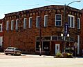
- Bank of Bigheart: Located in Barnsdall, this old bank building at 308 West Main Street was listed in 1984. It's a reminder of the early businesses that helped towns like Barnsdall grow.
- Bank of Hominy: Found at 102 West Main Street in Hominy, this bank was also added to the list in 1984. It played a big role in the town's early economy.
- Marland Filling Station: In Hominy, at 102 South Wood Street, you can find this old gas station. It was listed in 2002 and shows how important cars and the oil industry became in Oklahoma.
Important Community Buildings
Many buildings that were central to community life are also recognized. These include places where people gathered, learned, or ran the local government.
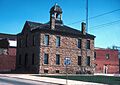
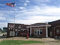
- City Hall (Pawhuska): The City Hall in Pawhuska, at Main and Grandview Avenue, was listed way back in 1976. This building has been a key spot for local government for a long time.
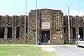
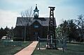
- Hominy Armory: This building at 201 North Regan Street in Hominy was listed in 1994. Armories were often used for military training and community events.
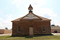
- Hominy School: The old Hominy School, located in the 200 block of South Pettit Street, was listed in 1988. Schools are super important because they shape the future of a community by educating its young people.
- Osage County Courthouse: The courthouse in Pawhuska, at 6th and Grandview Streets, was listed in 1984. This is where important legal decisions and government work for the whole county happen.
Native American Heritage
Osage County is the home of the Osage Nation, and several historic places are important to their culture and history.
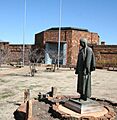
- Chief Ne-Kah-Wah-She-Tun-Kah Grave and Statue: Near Fairfax, off State Highway 18, is the grave and statue of Chief Ne-Kah-Wah-She-Tun-Kah. This site, listed in 1979, honors an important Osage leader.
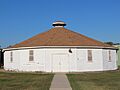
- Hominy Osage Round House: Located in the Indian Village in Hominy, this Round House was listed in 1979. Round Houses are very important cultural and ceremonial places for the Osage people.
- Osage Agency: On Agency Hill in Pawhuska, this site was listed in 1974. The Osage Agency was a key administrative center for the Osage Nation, especially during important times in their history.
Ranches and Oil History
The county's history is also tied to large ranches and the oil industry.
- Chapman-Barnard Ranch Headquarters: This ranch headquarters, located at 1511 County Route 4201 near Pawhuska, was listed in 2001. It represents the large ranching operations that were important to the area's economy.
- Barnsdall Main Street Well Site: West of the junction of State Highway 11 and Main Street in Barnsdall, this well site was listed in 1997. It reminds us of the oil boom that brought many changes and people to Oklahoma.
- Woolaroc Ranch Historic District: About 8 miles east of Barnsdall, this large area was listed in 2008. Woolaroc is a famous ranch, museum, and wildlife preserve that tells the story of the American West, including its oil history and Native American culture.
Images for kids
-
The Bank of Bigheart in Barnsdall.
-
The Bank of Hominy.
-
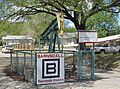
The Barnsdall Main Street Well.
-
The Blacksmith's House in Pawhuska.
-
The Chapman-Barnard Ranch Headquarters.
-
Pawhuska City Hall.
-
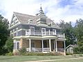
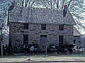
The Fred and Adeline Drummond House in Hominy.
-
The Hominy Armory.
-
The Hominy Osage Round House.
-
The Hominy School.
-
The Marland Filling Station in Hominy.
-
The Osage Agency in Pawhuska.
-

The Osage County Courthouse in Pawhuska.
-
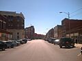
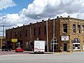
A view of the Pawhuska Downtown Historic District.
-
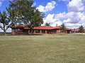
The Woolaroc Museum.


.jpg)

