National Register of Historic Places listings in McCurtain County, Oklahoma facts for kids
This page is about the National Register of Historic Places in McCurtain County, Oklahoma. These are special places in the United States that are officially recognized for their important history. Think of it like a list of really old and significant buildings, sites, or objects that tell us about the past.
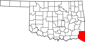
In McCurtain County, there are 16 places on this list. One of them is even a National Historic Landmark, which means it's extra important! You can often find these places on a map if their exact location is shared.
Contents
What are Historic Places?
The National Register of Historic Places is like a special club for buildings, sites, and objects that are important to American history, architecture, archaeology, engineering, or culture. When a place is added to this list, it means it's worth protecting and learning about. It helps people remember and appreciate the past.
McCurtain County's Special Spots
McCurtain County has many interesting places that have been added to the National Register. These include old houses, schools, churches, and even ancient Native American sites. Each one has a unique story to tell about the people who lived there and the events that happened.
Cool Historic Buildings
Let's look at a few examples of the cool historic buildings you can find in McCurtain County:
Wheelock Academy: A School with History
The Wheelock Academy is a very important place. It's located near Millerton and was added to the National Register way back in 1966. It was a school, especially for girls, and played a big role in education for Native American children in the area. It's even a National Historic Landmark!
The Old Frisco Train Station
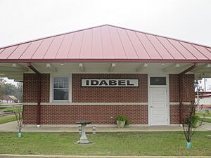
The Frisco Station in Idabel was once a busy train station. It was built in 1979 and is a great example of how people traveled and moved goods a long time ago. Train stations were super important for towns to grow and connect with other places.
Tiner School: Learning from the Past
The Tiner School is another historic school building, located east of Broken Bow. It was listed in 1980. Old schoolhouses like this show us what education was like for kids many years ago, often with just one or two rooms for all ages.
Other Interesting Buildings
- The Barnes-Steverson House in Idabel is an old home that tells us about how people lived in the past.
- The Garvin Rock Church in Garvin is a unique church building made of rock.
- The Idabel Armory was a building used by the military or National Guard.
- The Rouleau Hotel in Idabel was a place where travelers could stay.
- The Valliant School Gymnasium-Auditorium in Valliant was a place for sports and community events.
Ancient Sites and Mounds
McCurtain County also has some very old sites that show us about the people who lived here thousands of years ago. These include:
- The Grobin Davis Mound Group near Wright City.
- The Harkey Site near Idabel.
- The Pine Creek Mound Group near Bethel.
These "mound groups" are places where ancient people built large earth mounds, often for burials or ceremonies. They are very important for understanding early Native American cultures.
Why Do We Protect These Places?
Protecting these historic places is important because they help us understand our past. They are like giant history books that we can visit and learn from. By keeping them safe, we make sure that future generations can also learn about the people, events, and ways of life that shaped McCurtain County and the United States.
Images for kids


