McCurtain County, Oklahoma facts for kids
Quick facts for kids
McCurtain County
|
|
|---|---|
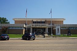
The McCurtain County Courthouse is located downtown in Idabel.
|
|
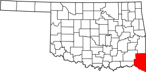
Location within the U.S. state of Oklahoma
|
|
 Oklahoma's location within the U.S. |
|
| Country | |
| State | |
| Founded | 1907 |
| Named for | An influential Choctaw Indian family |
| Seat | Idabel |
| Largest city | Idabel |
| Area | |
| • Total | 1,902 sq mi (4,930 km2) |
| • Land | 1,850 sq mi (4,800 km2) |
| • Water | 52 sq mi (130 km2) 2.8%% |
| Population
(2020)
|
|
| • Total | 30,814 |
| • Estimate
(2022)
|
30,931 |
| • Density | 16.6/sq mi (6.4/km2) |
| Congressional district | 2nd |
McCurtain County is a county located in the southeastern part of Oklahoma. In 2020, about 30,814 people lived there. The main town and county seat is Idabel.
The county was created in 1907 when Oklahoma became a state. It was formed from a part of the Choctaw Nation in what was called Indian Territory. The county is named after an important Choctaw family. Members like Jackson McCurtain, Edmund McCurtain, and Green McCurtain were leaders of the Choctaw people. Green McCurtain was the last chief when Oklahoma became a state.
Contents
History of McCurtain County
Before Oklahoma became a state, the land that is now McCurtain County was part of the Choctaw Nation. This area was divided into several smaller regions within the Choctaw Nation. In the 1820s, it was also a big part of Miller County, Arkansas Territory.
At first, the area was not very populated. There were no roads or bridges, and very few towns. Small trading posts had post offices along different trails. Towns started to grow when the Arkansas and Choctaw Railway was built through the area in 1902. Later, between 1910 and 1921, the Choctaw Lumber Company built more train tracks. These railways were still important for the area in the early 2000s.
When the county was first formed, it had trouble getting started because it didn't have much money. The Choctaw people's land was not taxed for 21 years, so the county couldn't collect much money. This meant no roads were built for about ten years after Oklahoma became a state. People and vehicles had to use ferries to cross big rivers because there were no bridges.
Beavers Bend State Park opened in 1937. This park made the region a popular place for tourists because it offers many fun outdoor activities.
On April 2, 1982, a very strong tornado, called an F5 tornado, hit the county.
Geography and Nature
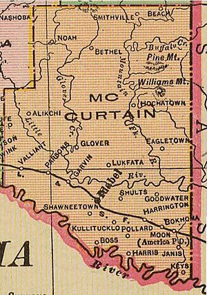
McCurtain County is in southeastern Oklahoma. It is part of a special area called Choctaw Country, which is known for tourism. The county covers about 1,902 square miles. About 52 square miles of this area is water.
It is the third-largest county in Oklahoma by land size. The land in McCurtain County changes from rolling hills in the north to flat, rich land near the Red River in the south. The Mountain Fork and Little River flow through the county. The Glover River also starts in McCurtain County and flows for about 33 miles.
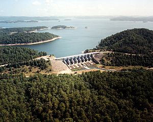
Broken Bow Lake was created in 1968 by building a dam on the Mountain Fork River. This river is one of only two places in Oklahoma where you can fish for trout all year round. The lowest point in the state of Oklahoma is on the Little River in McCurtain County, where it flows into Arkansas. McCurtain County is also one of the few places in Oklahoma where American alligators live naturally.
The county also has the McCurtain County Wilderness Area. This is a large protected area created in 1918. It is managed by the Oklahoma Department of Wildlife Conservation. There is also the Little River National Wildlife Refuge, which is managed by the U.S. Fish and Wildlife Service.
The town of Smithville in McCurtain County gets the most rain in Oklahoma each year, with an average of 55.71 inches.
Main Roads
 U.S. Highway 70
 U.S. Highway 259
 State Highway 3
 State Highway 4
 State Highway 37
 State Highway 87
 State Highway 98
Neighboring Counties
- Le Flore County (north)
- Polk County, Arkansas (northeast)
- Sevier County, Arkansas (east)
- Little River County, Arkansas (southeast)
- Bowie County, Texas (south)
- Red River County, Texas (southwest)
- Choctaw County (west)
- Pushmataha County (northwest)
Protected Natural Areas
- Little River National Wildlife Refuge
- Ouachita National Forest (part)
Population Facts
| Historical population | |||
|---|---|---|---|
| Census | Pop. | %± | |
| 1910 | 20,681 | — | |
| 1920 | 37,905 | 83.3% | |
| 1930 | 34,759 | −8.3% | |
| 1940 | 41,318 | 18.9% | |
| 1950 | 31,588 | −23.5% | |
| 1960 | 25,851 | −18.2% | |
| 1970 | 28,642 | 10.8% | |
| 1980 | 36,151 | 26.2% | |
| 1990 | 33,433 | −7.5% | |
| 2000 | 34,402 | 2.9% | |
| 2010 | 33,151 | −3.6% | |
| 2020 | 30,814 | −7.0% | |
| 2021 (est.) | 30,884 | −6.8% | |
| U.S. Decennial Census 1790–1960 1900–1990 1990–2000 2010–2019 |
|||
In 2000, there were 34,402 people living in McCurtain County. Most people were White (about 70.5%), followed by Native American (about 13.5%) and Black or African American (about 9.3%). A small number of people were from other backgrounds. About 3% of the population were Hispanic or Latino. Most people (94.4%) spoke English, but some also spoke Spanish (2.9%) or Choctaw (2.6%). By 2020, the population had gone down to 30,814 people.
In 2000, about 34% of homes had children under 18. More than half (53.3%) were married couples. The average age of people in the county was 36 years old.
The average income for a household in 2000 was about $24,162 per year. Some families and people in the county faced economic challenges.
Economy
The economy of McCurtain County has mostly been about farming and cutting down trees (forestry). The thick forests that once covered the area were cleared in the years after Oklahoma became a state. The cleared land was then used for small farms. Cotton was the main crop that farmers sold for money. However, the cotton market crashed during the Great Depression, a time when the economy was very bad.
After that, raising cattle, pigs, and chickens became more important than cotton farming. Farms in the Red River Valley started growing grains and food for animals instead of cotton.
Over time, new trees grew naturally, and people also planted many new trees. This helped the timber industry (lumber and wood products) become important again for the county's economy. The county also gets limestone, sand, and gravel from the ground, which are used for building things locally.
Towns and Communities
Cities
- Broken Bow
- Idabel (This is the county seat, where the county government is located)
Towns
Census-designated place
Other Small Communities
Famous People
- Harry Rossoll, who created the famous character Smokey Bear. He also made art for the Forest Heritage Center exhibits.
See also
 In Spanish: Condado de McCurtain para niños
 | Leon Lynch |
 | Milton P. Webster |
 | Ferdinand Smith |


