Sevier County, Arkansas facts for kids
Quick facts for kids
Sevier County
|
|
|---|---|

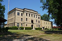
The Sevier County Courthouse is located in De Queen
|
|

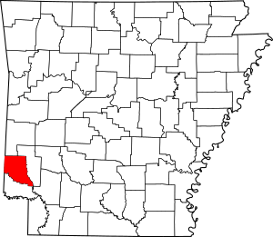
Location within the U.S. state of Arkansas
|
|
 Arkansas's location within the U.S. |
|
| Country | |
| State | |
| Founded | October 17, 1828 |
| Named for | Ambrose Hundley Sevier |
| Seat | De Queen |
| Largest city | De Queen |
| Area | |
| • Total | 581 sq mi (1,500 km2) |
| • Land | 565 sq mi (1,460 km2) |
| • Water | 16 sq mi (40 km2) 2.8% |
| Population
(2020)
|
|
| • Total | 15,839 |
| • Density | 27.262/sq mi (10.526/km2) |
| Time zone | UTC−6 (Central) |
| • Summer (DST) | UTC−5 (CDT) |
| Congressional district | 4th |
Sevier County is a county in Arkansas, a state in the United States. In 2020, about 15,839 people lived here. The main town and county seat is De Queen.
Sevier County was created on October 17, 1828. It was the 16th county in Arkansas. The county is named after Ambrose Sevier. He was a U.S. Senator from Arkansas.
Contents
History of Sevier County
Sevier County was officially formed on October 17, 1828. It was made from parts of Hempstead and Miller Counties. A few days later, on October 22, 1828, the county's size grew. More land south of the Red River was added.
The county seat is the main town where the county government is located. Sevier County's county seat has moved a few times. The first county seat was a place called Paraclifta.
Later, in 1867, a part of Sevier County became Little River County. This meant Paraclifta was no longer in the middle of Sevier County. So, a new county seat was needed.
Three brothers, James, William, and Matthew Locke, gave 120 acres of land. Another person, Royal Appleton, gave 60 acres. This land became the new county seat, named Lockesburg. This change happened on January 18, 1869.
In the late 1890s, a railroad company wanted to build tracks. Some people in Lockesburg did not want to sell their land for the railroad. So, the railroad was built through a different area. This area became the town of De Queen. In 1905, the county seat was moved to De Queen.
Geography of Sevier County
Sevier County covers about 581 square miles. Most of this area, 565 square miles, is land. The rest, about 16 square miles, is water. This water makes up about 2.8% of the county's total area.
Sevier County is sometimes called "The Land of Lakes." It is also known as "The Land of Fruits and Flowers." People also call it "The Home of Friendly People." The county has five lakes nearby. It also has five rivers, mountain streams, and many forests.
Famous People from Sevier County
Some well-known people have lived in Sevier County:
- Collin Raye, a famous country music singer.
- Wes Watkins, who was a Congressman for Oklahoma. He lived in De Queen when he was a child.
Main Roads
 Future Interstate 49
 U.S. Highway 59
 U.S. Highway 70
 U.S. Highway 71
 U.S. Highway 371
 Highway 24
 Highway 27
 Highway 41
Public Transport
- Jefferson Lines (a bus company)
Neighboring Counties
Sevier County shares borders with these other counties:
- Polk County (to the north)
- Howard County (to the east)
- Hempstead County (to the southeast)
- Little River County (to the south)
- McCurtain County, Oklahoma (to the west)
Protected Areas
- Pond Creek National Wildlife Refuge (a special area for wildlife)
Population Information
| Historical population | |||
|---|---|---|---|
| Census | Pop. | %± | |
| 1830 | 634 | — | |
| 1840 | 2,810 | 343.2% | |
| 1850 | 4,240 | 50.9% | |
| 1860 | 10,516 | 148.0% | |
| 1870 | 4,492 | −57.3% | |
| 1880 | 6,192 | 37.8% | |
| 1890 | 10,072 | 62.7% | |
| 1900 | 16,339 | 62.2% | |
| 1910 | 16,616 | 1.7% | |
| 1920 | 18,301 | 10.1% | |
| 1930 | 16,364 | −10.6% | |
| 1940 | 15,248 | −6.8% | |
| 1950 | 12,293 | −19.4% | |
| 1960 | 10,156 | −17.4% | |
| 1970 | 11,272 | 11.0% | |
| 1980 | 14,060 | 24.7% | |
| 1990 | 13,637 | −3.0% | |
| 2000 | 15,757 | 15.5% | |
| 2010 | 17,058 | 8.3% | |
| 2020 | 15,839 | −7.1% | |
| 2023 (est.) | 15,632 | −8.4% | |
| U.S. Decennial Census 1790–1960 1900–1990 1990–2000 2010 |
|||
2020 Census Details
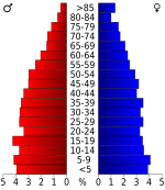
A census is a count of the population. The 2020 census showed that 15,839 people lived in Sevier County. There were 5,885 households and 4,279 families.
Here's a look at the different groups of people in Sevier County in 2020:
| Group | Number | Percentage |
|---|---|---|
| White (not Hispanic) | 8,400 | 53.03% |
| Black or African American (not Hispanic) | 550 | 3.47% |
| Native American | 305 | 1.93% |
| Asian | 60 | 0.38% |
| Pacific Islander | 241 | 1.52% |
| Other/Mixed | 775 | 4.89% |
| Hispanic or Latino | 5,508 | 34.77% |
Towns and Communities
Sevier County has several cities and towns:
Cities
- De Queen (This is the county seat)
- Horatio
- Lockesburg
Towns
Townships
Townships in Arkansas are the divisions of a county. Each township includes unincorporated areas; some may have incorporated cities or towns within part of their boundaries. Arkansas townships have limited purposes in modern times. However, the United States Census does list Arkansas population based on townships (sometimes referred to as "county subdivisions" or "minor civil divisions"). Townships are also of value for historical purposes in terms of genealogical research. Each town or city is within one or more townships in an Arkansas county based on census maps and publications. The townships of Sevier County are listed below; listed in parentheses are the cities, towns, and/or census-designated places that are fully or partially inside the township.
- Bear Creek (includes most of De Queen)
- Ben Lomond (includes Ben Lomond)
- Buckhorn
- Clear Creek (includes Horatio)
- Jefferson
- Mill Creek
- Mineral (includes Gillham)
- Monroe (includes a small part of De Queen)
- Paraclifta
- Red Colony (includes Lockesburg)
- Saline
- Washington
See also
 In Spanish: Condado de Sevier (Arkansas) para niños
 | Chris Smalls |
 | Fred Hampton |
 | Ralph Abernathy |


