Little River County, Arkansas facts for kids
Quick facts for kids
Little River County
|
|
|---|---|

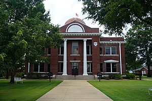
Little River County Courthouse in Ashdown
|
|

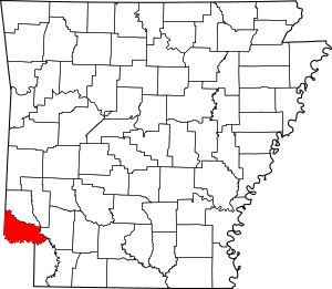
Location within the U.S. state of Arkansas
|
|
 Arkansas's location within the U.S. |
|
| Country | |
| State | |
| Founded | March 5, 1867 |
| Named for | Little River |
| Seat | Ashdown |
| Largest city | Ashdown |
| Area | |
| • Total | 565 sq mi (1,460 km2) |
| • Land | 532 sq mi (1,380 km2) |
| • Water | 33 sq mi (90 km2) 5.8%% |
| Population
(2020)
|
|
| • Total | 12,026 |
| • Density | 21.285/sq mi (8.218/km2) |
| Time zone | UTC−6 (Central) |
| • Summer (DST) | UTC−5 (CDT) |
| Congressional district | 4th |
Little River County is a place in southwest Arkansas. It shares borders with Texas and Oklahoma. In 2020, about 12,026 people lived there. Ashdown is the main town, also called the county seat.
Little River County is part of the larger Texarkana area. This area includes parts of Texas and Arkansas.
Contents
History of Little River County
Little River County became Arkansas's 59th county. It was created from Sevier County on March 5, 1867. This happened during the Reconstruction era, a time after the American Civil War. The county is named after the Little River.
This county is special because water surrounds it on all sides within Arkansas. The Little River, Millwood Lake, and the Red River form its borders inside the state. Only Miller County in Arkansas shares this unique feature.
Around 1895, a railway called the Arkansas and Choctaw Railway was built. It connected the towns of Arkinda and Ashdown. Later, around 1902-1903, the line was made longer. It went from Arkinda into Oklahoma and from Ashdown to Hope, Arkansas. Today, the Kiamichi Railroad operates this railway line.
Geography of Little River County
The U.S. Census Bureau says Little River County covers about 565 square miles. Most of this area, about 532 square miles, is land. The rest, about 33 square miles (5.8%), is water. It is one of the smallest counties in Arkansas by land area.
Major Roads in Little River County
These are the main roads that go through Little River County:
 Future Interstate 49
 U.S. Highway 59
 U.S. Highway 71
 Highway 32
 Highway 41
 Highway 108
Counties Next to Little River County
Little River County shares its borders with these other counties:
- Sevier County (to the north)
- Howard County (to the northeast)
- Hempstead County (to the east)
- Miller County (to the southeast)
- Bowie County, Texas (to the south)
- McCurtain County, Oklahoma (to the west)
Population of Little River County
| Historical population | |||
|---|---|---|---|
| Census | Pop. | %± | |
| 1870 | 3,236 | — | |
| 1880 | 6,404 | 97.9% | |
| 1890 | 8,903 | 39.0% | |
| 1900 | 13,731 | 54.2% | |
| 1910 | 13,597 | −1.0% | |
| 1920 | 16,301 | 19.9% | |
| 1930 | 15,515 | −4.8% | |
| 1940 | 15,932 | 2.7% | |
| 1950 | 11,690 | −26.6% | |
| 1960 | 9,211 | −21.2% | |
| 1970 | 11,194 | 21.5% | |
| 1980 | 13,952 | 24.6% | |
| 1990 | 13,966 | 0.1% | |
| 2000 | 13,628 | −2.4% | |
| 2010 | 13,171 | −3.4% | |
| 2020 | 12,026 | −8.7% | |
| 2023 (est.) | 11,805 | −10.4% | |
| U.S. Decennial Census 1790–1960 1900–1990 1990–2000 2010 |
|||
The population of Little River County has changed over many years. The table shows how many people lived there during different census years. A census is a count of all the people in a country.
2020 Census Information
| Race | Number | Percentage |
|---|---|---|
| White (non-Hispanic) | 8,593 | 71.45% |
| Black or African American (non-Hispanic) | 2,164 | 17.99% |
| Native American | 161 | 1.34% |
| Asian | 19 | 0.16% |
| Pacific Islander | 9 | 0.07% |
| Other/Mixed | 671 | 5.58% |
| Hispanic or Latino | 409 | 3.4% |
In 2020, the census counted 12,026 people living in Little River County. There were 5,363 households, which are groups of people living together. Also, there were 3,523 families.
Communities in Little River County
Little River County has several towns and cities.
Cities
Towns
Census-designated places
These are areas that are like towns but are not officially incorporated as cities or towns.
Other Unincorporated Places
These are smaller communities that are not officially part of a city or town.
- Comet
- Richmond
- Rocky Comfort
- Cerro Gordo
Townships
Townships in Arkansas are the divisions of a county. Each township includes unincorporated areas; some may have incorporated cities or towns within part of their boundaries. Arkansas townships have limited purposes in modern times. However, the United States Census does list Arkansas population based on townships (sometimes referred to as "county subdivisions" or "minor civil divisions"). Townships are also of value for historical purposes in terms of genealogical research. Each town or city is within one or more townships in an Arkansas county based on census maps and publications. The townships of Little River County are listed below; listed in parentheses are the cities, towns, and/or census-designated places that are fully or partially inside the township.
Notable People from Little River County
Some well-known people have lived in Little River County:
- Marion H. Crank: He was the Speaker of the Arkansas House of Representatives from 1963 to 1964. This means he was the leader of one part of the state government. He also ran for governor in 1968. He lived in Foreman and is buried there.
- Jeff Davis: He was a Democratic Senator for Arkansas. He also served as the 20th Governor of Arkansas.
See also
 In Spanish: Condado de Little River (Arkansas) para niños
 | Stephanie Wilson |
 | Charles Bolden |
 | Ronald McNair |
 | Frederick D. Gregory |


