Miller County, Arkansas facts for kids
Quick facts for kids
Miller County
|
|
|---|---|

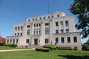
Miller County Courthouse in Texarkana
|
|

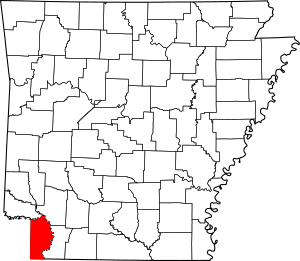
Location within the U.S. state of Arkansas
|
|
 Arkansas's location within the U.S. |
|
| Country | |
| State | |
| Founded | April 1, 1820; recreated December 22, 1874, following abolishment in 1838 |
| Named for | James Miller |
| Seat | Texarkana |
| Largest city | Texarkana |
| Area | |
| • Total | 637.48 sq mi (1,651.1 km2) |
| • Land | 623.98 sq mi (1,616.1 km2) |
| • Water | 13.5 sq mi (35 km2) 2.1%% |
| Population
(2020)
|
|
| • Total | 42,600 |
| • Density | 66.83/sq mi (25.802/km2) |
| Time zone | UTC−6 (Central) |
| • Summer (DST) | UTC−5 (CDT) |
| Congressional district | 4th |
Miller County is a county in the southwest corner of Arkansas. In 2020, about 42,600 people lived there. The main city and government center is Texarkana.
Miller County is part of the larger Texarkana Metropolitan Statistical Area, which includes parts of TX and Arkansas.
The county was first created on April 1, 1820. It was named after James Miller, who was the first governor of the Arkansas Territory. Miller County was the first county formed when Arkansas became a territory. It was later dissolved in 1838.
During a time called the Reconstruction era, Miller County was created again on December 22, 1874. This time, it was formed from a part of Lafayette County, which is a neighboring county.
Contents
History of Miller County
Early Beginnings and Changes
When Miller County was first made in 1820, it was much bigger. It included not only the area it covers today but also parts of what are now several counties in Texas. In 1831, the county's main town was in Clarksville, Texas.
When Arkansas became a state in 1836, Texas also declared itself an independent country. This led to a disagreement about the border between them. People in Miller County were represented in both the Arkansas government and the Texas government.
Arkansas tried to stop this by making it illegal for Miller County residents to hold office in Texas. But these efforts didn't work. In 1845, Texas joined the United States, and the border between Texas and Arkansas was finally decided. Because a large part of Miller County became part of Texas, the county was officially closed. The remaining land went back to Lafayette County.
The Miller County we know today was re-created in 1874. It was formed from parts of Lafayette County that were west and south of the Red River.
Geography of Miller County
Miller County is in the southwest part of Arkansas. It's known for its Piney Woods, which are forests full of pine trees. These forests were once important for the logging industry. Today, many areas have been cleared to grow crops like rice, soybeans, corn, and vegetables.
The county is also part of the Ark-La-Tex region. This is where Arkansas, Louisiana, and Texas meet. The Ark-La-Tex is an important economic area with cities like Shreveport, Louisiana, Tyler, Texas, Longview, Texas, and Texarkana.
The Red River forms the northern and eastern border of Miller County. However, the river has changed its path over time. The old path of the Red River still marks the county line for other nearby counties. Miller County covers about 637 square miles. Most of this (624 square miles) is land, and about 13.5 square miles (2.1%) is water.
Location and Neighbors
Miller County is about 143 miles southwest of Little Rock, Arkansas. It's also about 73 miles north of Shreveport, Louisiana, and 204 miles east of the Dallas–Fort Worth metroplex in Texas.
Miller County shares its borders with several other places:
- To the north: Little River County
- To the northeast: Hempstead County
- To the east: Lafayette County
- To the southeast: Bossier Parish (Louisiana)
- To the south: Caddo Parish (Louisiana)
- To the west: Cass County and Bowie County (Texas)
Waterways and Rivers
Miller County is part of the Red River watershed. This means all the water in the county eventually flows into the Red River. Besides the Red River, other important waterways include the Sulphur River, McKinney Bayou, and Bois D'Arc Creek. All of these flow into the Red River.
Swamps and bayous along the Sulphur River drain much of the western part of Miller County. There's a levee in the eastern part of the county. This levee separates the McKinney Bayou area from the Red River floodplain. Areas within the levee can sometimes flood from the Red River. For example, the town of Garland City had to be evacuated in 2015 due to flooding.
Protected Natural Areas
Miller County has two special protected areas:
- The Sandhills Natural Area: This area is owned by the Arkansas Natural Heritage Commission. It protects 274 acres of untouched sandhill plants and rolling hills. It's home to at least 40 rare plant species, more than any other natural area managed by the ANHC.
- The Sulphur River Wildlife Management Areas (WMA): This area is managed by the Arkansas Game and Fish Commission. It protects 16,520 acres of bottomland hardwood forest, cypress trees, oxbow lakes, and bayous along the Red River Valley. It was created in the 1950s and is open for activities like birding, camping, hunting, fishing, and hiking. A special 500-acre part of the WMA is kept as the Henry Moore Waterfowl Rest Area for birds.
People of Miller County
| Historical population | |||
|---|---|---|---|
| Census | Pop. | %± | |
| 1830 | 356 | — | |
| 1880 | 9,919 | — | |
| 1890 | 14,714 | 48.3% | |
| 1900 | 17,558 | 19.3% | |
| 1910 | 19,555 | 11.4% | |
| 1920 | 24,021 | 22.8% | |
| 1930 | 30,586 | 27.3% | |
| 1940 | 31,874 | 4.2% | |
| 1950 | 32,614 | 2.3% | |
| 1960 | 31,686 | −2.8% | |
| 1970 | 33,385 | 5.4% | |
| 1980 | 37,766 | 13.1% | |
| 1990 | 38,467 | 1.9% | |
| 2000 | 40,443 | 5.1% | |
| 2010 | 43,462 | 7.5% | |
| 2020 | 42,600 | −2.0% | |
| 2023 (est.) | 42,415 | −2.4% | |
| U.S. Decennial Census 1790–1960 1900–1990 1990–2000 2010 |
|||
Population in 2020
In 2020, the census showed that 42,600 people lived in Miller County. There were 16,426 households and 11,108 families.
| Race | Number | Percentage |
|---|---|---|
| White (not Hispanic) | 27,593 | 64.77% |
| Black or African American (not Hispanic) | 10,922 | 25.64% |
| Native American | 246 | 0.58% |
| Asian | 205 | 0.48% |
| Pacific Islander | 4 | 0.01% |
| Other/Mixed | 2,047 | 4.81% |
| Hispanic or Latino | 1,583 | 3.72% |
Population in 2010
Racial/Ethnic Makeup of Miller County (2010) White Non-Hispanic (70.6%) Black Non-Hispanic (24.4%) Native American Non-Hispanic (0.6%) Asian Non-Hispanic (0.5%) Pacific Islander Non-Hispanic (0.0%) Other Non-Hispanic (0.1%) Two or more races Non-Hispanic (1.4%) Hispanic Any Race (2.4%)
In 2010, there were 43,462 people living in Miller County. The average number of people per square mile was about 68.
About 24.3% of the people were under 18 years old. The median age was 37.2 years. For every 100 females, there were about 97 males.
The average income for a household in the county was $40,307. For families, it was $47,960. About 18.1% of the population lived below the poverty line. This included 29.1% of those under 18.
Education in Miller County
Most adults in Miller County (about 85.5% in 2016) have a high school degree or higher. This is similar to the average for Arkansas and the whole country. However, fewer people in Miller County (14.5%) have a bachelor's degree or higher compared to the state and national averages.
Public Schools
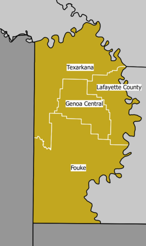
Several public school districts serve different parts of Miller County:
- Fouke School District
- Genoa Central School District
- Lafayette County School District
- Texarkana Arkansas School District (TASD)
The Texarkana Arkansas School District (TASD) is the largest. The Fouke District serves the southern half of the county, and the Genoa District covers a small area around Genoa. Students from these districts can graduate from Arkansas High School, Fouke High School, or Genoa Central High School. All these high schools offer Advanced Placement (AP) classes and are approved by the Arkansas Department of Education.
TASD also has the Washington Academy Charter School, which is a special public charter school. Students can also attend the Texarkana Area Vocational Center for job training. Arkansas High School works with the University of Arkansas Community College at Hope (UACCH) Texarkana Campus, allowing students to earn college credits early.
Students in the northeast part of Miller County, near Garland, go to schools in the Lafayette County School District.
Colleges and Universities
Miller County has one college: the Texarkana campus of the University of Arkansas Community College at Hope. This is a public community college.
Nearby, in Texarkana, Texas, you can find:
- Texas A&M University–Texarkana: A public four-year university.
- Texarkana College: Another community college.
Other colleges in the region include Cossatot Community College in De Queen, Arkansas, and Southern Arkansas University in Magnolia. There are also several colleges near Shreveport, Louisiana.
Libraries
- The Texarkana Public Library is located at 600 West 3rd Street. It offers books, e-books, movies, and services for research, youth, business, and family history.
- The Ann & Dewey Fowler Community Library is in Fouke, at 305 N Snell Street. It's in a beautifully restored Victorian house.
Communities in Miller County
Cities
- Texarkana (This is the county seat, where the main government offices are.)
Towns
Unincorporated Communities
These are smaller communities that are not officially cities or towns.
- Artex
- Beck
- Black Diamond
- Boggy
- Boyd
- Brightstar
- Capps City
- Clear Lake Junction
- Clipper
- Doddridge
- Dooley
- Fairland
- Ferguson Crossroads
- Fort Lynn
- Genoa
- Gertrude
- Hammons
- Hervey
- Homan
- Index
- Jonesville
- Kiblah
- Lakewood Estates
- Mandeville
- Mayton
- McKinney
- Mount Pleasant
- Paup
- Pleasant Hill
- Ravanna
- Rocky Mound
- Rondo
- Smithville
- Sylverino
Historical Communities
These are communities that no longer exist.
- Boggy
- Era
- Roverts
- Spring Bank
- Wona
Townships
Townships in Arkansas are the divisions of a county. Each township includes unincorporated areas; some may have incorporated cities or towns within part of their boundaries. Arkansas townships have limited purposes in modern times. However, the United States Census does list Arkansas population based on townships (sometimes referred to as "county subdivisions" or "minor civil divisions"). Townships are also of value for historical purposes in terms of genealogical research. Each town or city is within one or more townships in an Arkansas county based on census maps and publications. The townships of Miller County are listed below; listed in parentheses are the cities, towns, and/or census-designated places that are fully or partially inside the township. Townships are smaller areas within a county, often used for administrative purposes.
Transportation and Services
Main Roads
Miller County has several important highways that help people travel through the area.
 Interstate 30
 Interstate 49
 U.S. Highway 59
 U.S. Highway 67
 U.S. Highway 71
 U.S. Highway 82
 Highway 108
 Highway 134
 Highway 160
 Highway 196
 Highway 237
 Highway 245
 Highway 296
 Highway 549
Water Services
The Arkansas Department of Health makes sure that public water systems are safe. Miller County has six main community water systems:
- Texarkana Water Utilities (TWU)
- Fouke Waterworks
- Miller County Public Water Authority (PWA)
- Garland Waterworks
- Eastern Cass Water Supply Corporation
- Shady Acres Mobile Home Park
Texarkana Water Utilities (TWU) provides drinking water to both sides of Texarkana (Arkansas and Texas). It gets its water from Lake Millwood in Arkansas and Lake Wright Patman in Texas. The Miller County PWA buys its water from TWU. The other water systems are smaller and get their water from underground sources.
See also
 In Spanish: Condado de Miller (Arkansas) para niños
 | Audre Lorde |
 | John Berry Meachum |
 | Ferdinand Lee Barnett |


