Caddo Parish, Louisiana facts for kids
Quick facts for kids
Caddo Parish
|
|||
|---|---|---|---|
| Parish of Caddo | |||

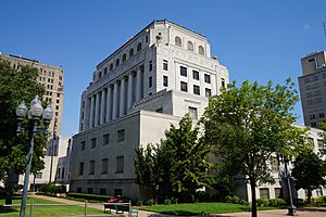
Caddo Parish Courthouse in Shreveport
|
|||
|
|||

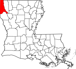
Location within the U.S. state of Louisiana
|
|||

Louisiana's location within the U.S.
|
|||
| Country | |||
| State | Louisiana | ||
| Region | North | ||
| Founded | January 18, 1838 | ||
| Named for | Caddo Native Americans | ||
| Parish seat (and largest city) | Shreveport | ||
| Incorporated municipalities |
11 (total)
1 city, 5 towns, 5 villages
(located entirely or partially within parish boundaries) |
||
| Area | |||
| • Total | 2,430 km2 (937 sq mi) | ||
| • Land | 2,280 km2 (879 sq mi) | ||
| • Water | 150 km2 (58 sq mi) | ||
| • percentage | 16 km2 (6.2 sq mi) | ||
| Population
(2020)
|
|||
| • Total | 237,848 | ||
| • Density | 98.01/km2 (253.84/sq mi) | ||
| Time zone | UTC-6 (CST) | ||
| • Summer (DST) | UTC-5 (CDT) | ||
| Area code | 318 | ||
| Congressional district | 4th | ||
| Website | official website: http://www.caddo.org | ||

Caddo Parish is a special kind of county in the northwestern part of Louisiana. It's named after the Caddo Native American people. In 2020, about 237,848 people lived here. The main city and biggest town is Shreveport. It grew up along the Red River.
Shreveport is the main center for business and culture in the "Ark-La-Tex" region. This area includes parts of Arkansas, Louisiana, and Texas. Caddo Parish is part of the larger Shreveport–Bossier City metropolitan area.
Contents
History of Caddo Parish
Caddo Parish was created in 1838. It was formed from a larger area called Natchitoches Parish. The government decided to name it after the local Caddo Native American tribes.
Geography and Location
Caddo Parish covers a total area of about 937 square miles. Most of this is land, about 879 square miles. The rest, about 58 square miles, is water. This means about 6.2% of the parish is covered by water.
Main Roads in Caddo Parish
You can find several important highways in Caddo Parish:
 Interstate 20
 Interstate 220
 Interstate 49
 U.S. Highway 71
 U.S. Highway 79
 U.S. Highway 80
 U.S. Highway 171
Neighboring Areas
Caddo Parish shares borders with several other counties and parishes:
- Miller County, Arkansas (to the north)
- Lafayette County, Arkansas (to the northeast)
- Bossier Parish (to the east)
- Red River Parish (to the southeast)
- De Soto Parish (to the south)
- Panola County, Texas (to the southwest)
- Harrison County (to the west)
- Marion County, Texas (to the west)
- Cass County, Texas (to the northwest)
Protected Natural Areas
Part of the Red River National Wildlife Refuge is located in Caddo Parish. This is a special area set aside to protect wildlife.
Communities in Caddo Parish
Caddo Parish has many different communities, from a large city to small villages.
City
- Shreveport (This is the main city and the parish seat.)
Towns
- Blanchard (This town is close to Shreveport.)
- Greenwood (Another town near Shreveport.)
- Oil City
- Vivian
Villages
Other Communities
- Lakeview (This is a census-designated place near Shreveport.)
Some areas in Caddo Parish are not officially part of a city or town. These are called unincorporated communities:
- Bethany (partly in Texas)
- Conn
- Dixie
- Forbing
- Keithville (This area is close to Shreveport.)
Population and People
The population of Caddo Parish has changed over the years. In 1840, there were 5,282 people. By 2020, the population had grown to 237,848.
| Historical population | |||
|---|---|---|---|
| Census | Pop. | %± | |
| 1840 | 5,282 | — | |
| 1850 | 8,884 | 68.2% | |
| 1860 | 12,140 | 36.7% | |
| 1870 | 21,714 | 78.9% | |
| 1880 | 26,296 | 21.1% | |
| 1890 | 31,555 | 20.0% | |
| 1900 | 44,499 | 41.0% | |
| 1910 | 58,200 | 30.8% | |
| 1920 | 83,265 | 43.1% | |
| 1930 | 124,670 | 49.7% | |
| 1940 | 150,203 | 20.5% | |
| 1950 | 176,547 | 17.5% | |
| 1960 | 223,859 | 26.8% | |
| 1970 | 230,184 | 2.8% | |
| 1980 | 252,358 | 9.6% | |
| 1990 | 248,253 | −1.6% | |
| 2000 | 252,161 | 1.6% | |
| 2010 | 254,969 | 1.1% | |
| 2020 | 237,848 | −6.7% | |
| U.S. Decennial Census 1790-1960 1900-1990 1990-2000 2010-2019 |
|||
In 2020, there were 237,848 people living in the parish. There were about 92,589 households. Many different groups of people live in Caddo Parish. In 2020, about 48.25% of the people were Black or African American. About 42.77% were White. Other groups like Asian, Native American, and people of mixed races also live here. About 3.52% of the population identified as Hispanic or Latino.
In 2010, about 26.8% of the people were under 18 years old. The average age was about 35 years.
Economy and Jobs
The economy of Caddo Parish mainly revolves around the city of Shreveport. Big companies like Amazon and Walmart have a presence here. Other well-known stores like Best Buy and Target also help the economy.
Even with these big companies, some areas in Caddo Parish have lower incomes. For example, in 2014, West Shreveport had a lower average income compared to other areas. In 2020, about 22.9% of the people in the parish lived below the poverty line. This means they had lower incomes.
However, the Shreveport–Bossier City metropolitan area is working to grow its economy. New projects are helping to create jobs and bring more attention to the region.
Here are some of the largest employers in the area as of 2017:
| Employer | Employees | Note | |
|---|---|---|---|
| 1 | Caddo Parish Public Schools (CPPS) | 9,416 | |
| 2 | Willis-Knighton Medical Center | 6,732 | |
| 3 | University Health | 6,372 | |
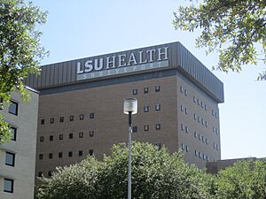
| 4 | LSU Health Shreveport | 2,762 | |
| 5 | City of Shreveport | 2,569 |
Education in Caddo Parish
The Caddo Parish School Board runs the public schools in the area. There are also fourteen private schools in the parish.
For higher education, students can attend Bossier Parish Community College. There are also private colleges like Centenary College of Louisiana and LSU Shreveport.
Community Facilities
The Caddo Correctional Center is a facility in Caddo Parish. It was built in 1994 and can hold many people. It is the largest facility of its kind in the Ark-La-Tex region.
See also
 In Spanish: Parroquia de Caddo para niños
 | Precious Adams |
 | Lauren Anderson |
 | Janet Collins |


