Marion County, Texas facts for kids
Quick facts for kids
Marion County
|
|
|---|---|

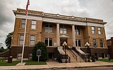
Marion County Courthouse in Jefferson
|
|

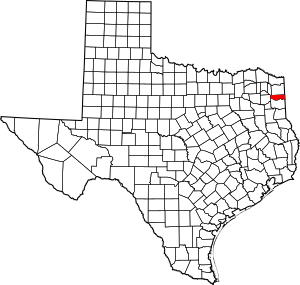
Location within the U.S. state of Texas
|
|
 Texas's location within the U.S. |
|
| Country | |
| State | |
| Founded | 1860 |
| Named for | Francis Marion |
| Seat | Jefferson |
| Largest city | Jefferson |
| Area | |
| • Total | 420 sq mi (1,100 km2) |
| • Land | 381 sq mi (990 km2) |
| • Water | 39 sq mi (100 km2) 9.4%% |
| Population
(2020)
|
|
| • Total | 9,725 |
| • Density | 23.15/sq mi (8.94/km2) |
| Time zone | UTC−6 (Central) |
| • Summer (DST) | UTC−5 (CDT) |
| Congressional district | 1st |
Marion County is a county found in the state of Texas. In 2020, about 9,725 people lived there. The main town, or county seat, is Jefferson. Marion County is in East Texas. It is named after Francis Marion, a famous general from the American Revolutionary War. People called him the "Swamp Fox."
Contents
History
Early People and Settlers
Long ago, the Caddoan Mississippian culture lived in this area. They were farmers. In 1541, the Hernando de Soto expedition came through. This led to fights with the Native Americans. European missionaries also brought diseases like smallpox and measles. These diseases harmed the Caddo people. Eventually, the Caddo had to move to special lands called reservations.
Later, in the 1800s, other Native American groups like the Shawnee, Delaware, and Kickapoo also moved to this area.
How Marion County Began
Marion County was created in 1860 from Cass County. It was named after General Francis Marion. The town of Jefferson became the county seat. It was named after Thomas Jefferson.
Many early settlers came from other southern states. They brought enslaved African Americans with them to work. By 1860, more than half of the people in the county were enslaved. In 1861, the county's white male voters chose to leave the Union. This led to the American Civil War. The county made money from contracts with the Confederate government during the war.
After the Civil War
After the Civil War, there were tough times. In 1869, a steamboat called the Mittie Stephens caught fire. Many people died in the fire or in the river.
After the war, some white groups used violence against the newly freed African Americans. In 1869, a leader named George Washington Smith was killed in Jefferson. Because of this, the government sent soldiers to Jefferson. These soldiers helped protect the Black community during a time called Reconstruction.
During Reconstruction, many Black voters in the county supported the Republican Party. But later, new laws made it hard for Black people to vote. This was called disenfranchisement. It meant they couldn't vote in important elections. This unfair practice lasted until 1944. Then, the U.S. Supreme Court said it was against the law.
The Marion County courthouse, made of brick, was built in 1914. A monument honoring soldiers from the Civil War was placed outside the courthouse.
Caddo Lake State Park was first suggested in 1924. During the Great Depression, from 1933 to 1937, men from the Civilian Conservation Corps worked there. They built cabins and a recreation hall for visitors.
Geography
Marion County covers about 420 square miles. About 381 square miles are land, and 39 square miles are water. This means about 9.4% of the county is water.
Main Roads
Several important roads pass through Marion County:
 U.S. Highway 59
 State Highway 43
 State Highway 49
 State Highway 155
 Farm to Market Road 134
 Farm to Market Road 248
 Farm to Market Road 2208
 Farm to Market Road 726
 Farm to Market Road 729
 Farm to Market Road 727
 Farm to Market Road 805
 Farm to Market Road 2683
Neighboring Counties
Marion County shares borders with these other counties:
- Cass County (north)
- Caddo Parish, Louisiana (east)
- Harrison County (south)
- Upshur County (west)
- Morris County (northwest)
Communities
Here are some of the towns and communities in Marion County:
- Corinth
- Jefferson (the county seat)
- Pine Harbor
- Warlock
Population Changes
| Historical population | |||
|---|---|---|---|
| Census | Pop. | %± | |
| 1860 | 3,977 | — | |
| 1870 | 8,562 | 115.3% | |
| 1880 | 10,983 | 28.3% | |
| 1890 | 10,862 | −1.1% | |
| 1900 | 10,754 | −1.0% | |
| 1910 | 10,472 | −2.6% | |
| 1920 | 10,886 | 4.0% | |
| 1930 | 10,371 | −4.7% | |
| 1940 | 11,457 | 10.5% | |
| 1950 | 10,172 | −11.2% | |
| 1960 | 8,049 | −20.9% | |
| 1970 | 8,517 | 5.8% | |
| 1980 | 10,360 | 21.6% | |
| 1990 | 9,984 | −3.6% | |
| 2000 | 10,941 | 9.6% | |
| 2010 | 10,546 | −3.6% | |
| 2020 | 9,725 | −7.8% | |
| U.S. Decennial Census 1850–2010 2010–2020 |
|||
| Race / Ethnicity (NH = Non-Hispanic) | Pop 2000 | Pop 2010 | Pop 2020 | % 2000 | % 2010 | % 2020 |
|---|---|---|---|---|---|---|
| White alone (NH) | 7,818 | 7,564 | 6,869 | 71.46% | 71.72% | 70.63% |
| Black or African American alone (NH) | 2,599 | 2,319 | 1,846 | 23.75% | 21.99% | 18.98% |
| Native American or Alaska Native alone (NH) | 79 | 72 | 69 | 0.72% | 0.68% | 0.71% |
| Asian alone (NH) | 23 | 50 | 48 | 0.21% | 0.47% | 0.49% |
| Pacific Islander alone (NH) | 0 | 3 | 0 | 0.00% | 0.03% | 0.00% |
| Other race alone (NH) | 3 | 8 | 45 | 0.03% | 0.08% | 0.46% |
| Mixed race or Multiracial (NH) | 156 | 202 | 459 | 1.43% | 1.92% | 4.72% |
| Hispanic or Latino (any race) | 263 | 328 | 389 | 2.40% | 3.11% | 4.00% |
| Total | 10,941 | 10,546 | 9,725 | 100.00% | 100.00% | 100.00% |
In 2000, there were 10,941 people living in Marion County. By 2020, the population had changed to 9,725 people. The county is made up of different groups of people. In 2020, most people were non-Hispanic white (about 70.63%). About 18.98% were Black or African American. Other groups included Native American, Asian, and people of mixed races. About 4% of the population was Hispanic or Latino.
Education
Students in Marion County attend schools in these districts:
- Avinger Independent School District
- Jefferson Independent School District
- Ore City Independent School District
Everyone in Marion County can also get college services from Panola College.
See also
 In Spanish: Condado de Marion (Texas) para niños
 | Misty Copeland |
 | Raven Wilkinson |
 | Debra Austin |
 | Aesha Ash |


