Upshur County, Texas facts for kids
Quick facts for kids
Upshur County
|
|
|---|---|

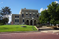
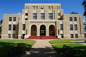
Upshur County Courthouse
|
|

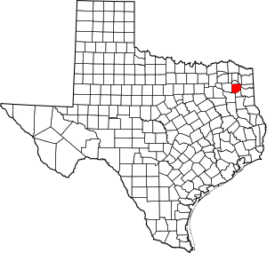
Location within the U.S. state of Texas
|
|
 Texas's location within the U.S. |
|
| Country | |
| State | |
| Founded | 1846 |
| Named for | Abel P. Upshur |
| Seat | Gilmer |
| Largest city | Gladewater |
| Area | |
| • Total | 593 sq mi (1,540 km2) |
| • Land | 583 sq mi (1,510 km2) |
| • Water | 9.7 sq mi (25 km2) 1.6% |
| Population
(2020)
|
|
| • Total | 40,892 |
| • Density | 68.96/sq mi (26.625/km2) |
| Time zone | UTC−6 (Central) |
| • Summer (DST) | UTC−5 (CDT) |
| Congressional districts | 1st, 5th |
Upshur County is a county in eastern Texas. In 2020, about 40,892 people lived there. The main town and county seat is Gilmer. The county is named after Abel P. Upshur. He was the U.S. Secretary of State for President John Tyler.
Upshur County is part of the Longview area. It is also part of the larger Longview–Marshall area.
Contents
History of Upshur County
People have lived in the area now known as Upshur County for at least 10,000 years. The Caddoan people lived here long ago. They left around 1750, likely because of new illnesses. These diseases were brought by Europeans.
Later, some Cherokee people moved here. They came from their homes in Georgia and Alabama. In 1839, European-American settlers forced the Cherokee to leave. This happened after they were moved from the Southeast.
The first European-American settler in Upshur County was probably Isaac Moody. He settled there in 1836. The county was named for Abel Parker Upshur. He served as Secretary of State under President John Tyler.
Upshur County is special for another reason. It has the largest settlement in Texas started by the Church of Jesus Christ of Latter-day Saints. In 1904, the Latter-day Saint Southwestern States Mission started a community. This community was built in Kelsey, Texas.
On March 21, 2022, a strong EF-2 tornado hit Upshur County. Winds reached about 135 miles per hour. There was a lot of damage, but no one died. This tornado was part of a larger storm system.
Geography of Upshur County
Upshur County covers about 593 square miles. Most of this area, 583 square miles, is land. The rest, about 9.7 square miles, is water. This means about 1.6% of the county is covered by water.
Main Roads in Upshur County
 U.S. Highway 80
 U.S. Highway 259
 U.S. Highway 271
 State Highway 154
 State Highway 155
 State Highway 300
Neighboring Counties
- Camp County (north)
- Morris County (northeast)
- Marion County (east)
- Harrison County (southeast)
- Gregg County (south)
- Smith County (southwest)
- Wood County (west)
Communities in Upshur County
Cities
- Clarksville City (mostly in Gregg County)
- East Mountain (small part in Gregg County)
- Gilmer (county seat)
- Gladewater (partly in Gregg County)
- Ore City
- Union Grove
- Warren City (mostly in Gregg County)
Town
Unincorporated Communities
Population of Upshur County
| Historical population | |||
|---|---|---|---|
| Census | Pop. | %± | |
| 1850 | 3,394 | — | |
| 1860 | 10,645 | 213.6% | |
| 1870 | 12,039 | 13.1% | |
| 1880 | 10,266 | −14.7% | |
| 1890 | 12,695 | 23.7% | |
| 1900 | 16,266 | 28.1% | |
| 1910 | 19,960 | 22.7% | |
| 1920 | 22,472 | 12.6% | |
| 1930 | 22,297 | −0.8% | |
| 1940 | 26,178 | 17.4% | |
| 1950 | 20,822 | −20.5% | |
| 1960 | 19,793 | −4.9% | |
| 1970 | 20,976 | 6.0% | |
| 1980 | 28,595 | 36.3% | |
| 1990 | 31,370 | 9.7% | |
| 2000 | 35,291 | 12.5% | |
| 2010 | 39,309 | 11.4% | |
| 2020 | 40,892 | 4.0% | |
| U.S. Decennial Census 1850–2010 2010 2020 |
|||
In 2020, Upshur County had 40,892 people. In 2000, there were 35,291 people. The county had about 13,290 households. Most of these were families.
The population density was about 60 people per square mile. There were about 14,930 homes. On average, there were 25 homes per square mile.
Education in Upshur County
Several school districts serve Upshur County. They help students get a good education.
- Big Sandy ISD (also in Wood County)
- Gilmer ISD
- Gladewater ISD (also in Gregg County)
- Harmony ISD (also in Wood County)
- New Diana ISD (small part in Harrison County)
- Ore City ISD (small part in Marion County)
- Pittsburg ISD
- Union Grove ISD (small part in Gregg County)
- Union Hill ISD (mostly in Upshur County)
Students can also attend local colleges. Kilgore Junior College serves many areas in the county. These include Big Sandy, Gilmer, Gladewater, New Diana, and Union Grove school districts. Northeast Texas Community College serves students in Harmony, Ore City, and Union Hill school districts.
Media in Upshur County
The main newspaper for Upshur County is The Gilmer Mirror. Another newspaper, Gladewater Mirror, has been published since 1949. It started as a daily paper and is now a weekly paper.
See also
 In Spanish: Condado de Upshur (Texas) para niños
 | Frances Mary Albrier |
 | Whitney Young |
 | Muhammad Ali |


