Camp County, Texas facts for kids
Quick facts for kids
Camp County
|
|
|---|---|

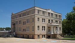
Camp County Courthouse in Pittsburg
|
|

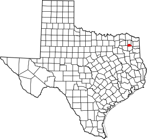
Location within the U.S. state of Texas
|
|
 Texas's location within the U.S. |
|
| Country | |
| State | |
| Founded | 1874 |
| Named for | John Lafayette Camp |
| Seat | Pittsburg |
| Largest city | Pittsburg |
| Area | |
| • Total | 203 sq mi (530 km2) |
| • Land | 196 sq mi (510 km2) |
| • Water | 7.4 sq mi (19 km2) 3.6% |
| Population
(2020)
|
|
| • Total | 12,464 |
| • Density | 61.40/sq mi (23.71/km2) |
| Time zone | UTC−6 (Central) |
| • Summer (DST) | UTC−5 (CDT) |
| Congressional district | 1st |
Camp County is a special area, or county, located in the eastern part of Texas. It's like a smaller region within the state. In 2020, about 12,464 people lived here. The main town, where the county government is located, is called Pittsburg. Camp County was started in 1874. It got its name from John Lafayette Camp, who was an important politician in Texas.
Contents
Geography of Camp County
Camp County covers a total area of about 203 square miles (526 square kilometers). Most of this area is land, but about 7.4 square miles (19 square kilometers) is covered by water. This makes Camp County one of the smallest counties in Texas.
Main Roads in Camp County
These are the most important highways that run through Camp County:
Neighboring Counties
Camp County shares its borders with several other counties:
- To the north: Titus County
- To the east: Morris County
- To the south: Upshur County
- To the southwest: Wood County
- To the west: Franklin County
Towns and Communities
Camp County has a few towns and many smaller communities where people live.
City
- Pittsburg: This is the biggest town and the county seat, meaning it's the center for the county's government.
Town
Smaller Communities
These are places where people live, but they are not officially organized as cities or towns:
- Center Point
- Ebenezer
- Harvard
- Leesburg
- Newsome
- Pine
Old Towns (Ghost Towns)
Some places in Camp County used to be towns but are now mostly empty or gone. These are sometimes called "ghost towns":
- Crossroads
- Holly Springs
- Matinburg
People of Camp County
The number of people living in Camp County has changed over the years. In 1880, there were about 5,951 people. By 2000, the population had grown to 11,549. In 2010, it was 12,401, and by the 2020 census, it reached 12,464 people.
In 2000, most people in Camp County were White (about 69.53%), followed by African American (19.20%). A smaller number of people were Native American or Asian. About 14.78% of the population identified as Hispanic or Latino.
By 2020, the population had become more diverse. About 54.03% of the people were non-Hispanic White, and 15.06% were Black or African American. The number of Asian residents grew to 0.84%. Also, a larger part of the population, about 25.85%, identified as Hispanic or Latino. This shows that Camp County, like many other parts of the United States, is becoming home to people from many different backgrounds.
See also
 In Spanish: Condado de Camp para niños
 | William M. Jackson |
 | Juan E. Gilbert |
 | Neil deGrasse Tyson |

