
Howard County, Arkansas facts for kids
Quick facts for kids
Howard County
|
|
|---|---|

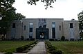
Howard County Courthouse in Nashville, Arkansas
|
|

Location within the U.S. state of Arkansas
|
|
 Arkansas's location within the U.S. |
|
| Country | |
| State | |
| Founded | April 17, 1873 |
| Seat | Nashville |
| Largest city | Nashville |
| Area | |
| • Total | 595 sq mi (1,540 km2) |
| • Land | 589 sq mi (1,530 km2) |
| • Water | 6.8 sq mi (18 km2) 1.1%% |
| Population
(2020)
|
|
| • Total | 12,785 |
| • Density | 21.487/sq mi (8.296/km2) |
| Time zone | UTC−6 (Central) |
| • Summer (DST) | UTC−5 (CDT) |
| Congressional district | 4th |
Howard County is a county located in the state of Arkansas in the United States. In 2020, about 12,785 people lived here. The main town and county seat is Nashville. Howard County was created on April 17, 1873. It was named after James Howard, who was a state senator. It is known as a "dry county," which means that the sale of alcohol is generally not allowed.
Contents
Howard County's Location and Land
Howard County covers a total area of about 595 square miles (1,541 square kilometers). Most of this area, about 589 square miles (1,525 square kilometers), is land. The remaining small part is water, like rivers and lakes.
Important Roads in Howard County
Several major highways pass through Howard County, making it easy to travel around. These roads help connect the different towns and communities.
 U.S. Highway 70
 U.S. Highway 278
 U.S. Highway 371
 Highway 26
 Highway 27
 Highway 84
Neighboring Counties
Howard County shares its borders with several other counties. Knowing these helps you understand its location within Arkansas.
- Polk County (to the north)
- Montgomery County (to the northeast)
- Pike County (to the east)
- Hempstead County (to the southeast)
- Little River County (to the southwest)
- Sevier County (to the west)
Protected Natural Areas
Part of the Ouachita National Forest is located in Howard County. A national forest is a large area of land protected by the government. It is managed for its natural beauty, wildlife, and resources. People can often visit these forests for hiking, camping, and enjoying nature.
People of Howard County
The number of people living in Howard County has changed over the years. The population has grown and shrunk at different times.
| Historical population | |||
|---|---|---|---|
| Census | Pop. | %± | |
| 1880 | 9,917 | — | |
| 1890 | 13,789 | 39.0% | |
| 1900 | 14,076 | 2.1% | |
| 1910 | 16,898 | 20.0% | |
| 1920 | 18,565 | 9.9% | |
| 1930 | 17,489 | −5.8% | |
| 1940 | 16,621 | −5.0% | |
| 1950 | 13,342 | −19.7% | |
| 1960 | 10,878 | −18.5% | |
| 1970 | 11,412 | 4.9% | |
| 1980 | 13,459 | 17.9% | |
| 1990 | 13,569 | 0.8% | |
| 2000 | 14,300 | 5.4% | |
| 2010 | 13,789 | −3.6% | |
| 2020 | 12,785 | −7.3% | |
| 2023 (est.) | 12,533 | −9.1% | |
| U.S. Decennial Census 1790–1960 1900–1990 1990–2000 2010 |
|||

In 2020, the census showed that 12,785 people lived in Howard County. These people lived in 5,142 households, and there were 3,503 families. The population is made up of people from many different backgrounds. Most residents are White, followed by African American, and then Hispanic or Latino people. There are also smaller groups of Native American, Asian, and other races.
Towns and Communities
Howard County has several towns and smaller communities where people live.
Cities in Howard County
- Dierks
- Mineral Springs
- Nashville (This is the county seat, meaning it's where the county government is located.)
Towns in Howard County
Other Communities
Some communities are called "census-designated places." This means they are recognized for census purposes but are not officially incorporated as cities or towns.
There are also many smaller, unincorporated communities throughout the county. These are places where people live but do not have their own local government. Some examples include Athens, Corinth, Midway, Mineola, Okay, Schaal, and Umpire.
Images for kids
-
Howard County Courthouse in Nashville, Arkansas
See also
 In Spanish: Condado de Howard (Arkansas) para niños
