Choctaw County, Oklahoma facts for kids
Quick facts for kids
Choctaw County
|
|
|---|---|

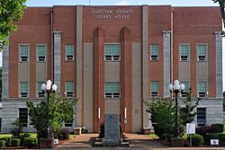
The Choctaw County Courthouse in Hugo.
|
|

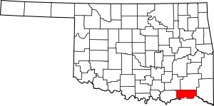
Location within the U.S. state of Oklahoma
|
|
 Oklahoma's location within the U.S. |
|
| Country | |
| State | |
| Founded | 1907 |
| Seat | Hugo |
| Largest city | Hugo |
| Area | |
| • Total | 800 sq mi (2,000 km2) |
| • Land | 770 sq mi (2,000 km2) |
| • Water | 29 sq mi (80 km2) 3.7%% |
| Population
(2020)
|
|
| • Total | 14,204 |
| • Density | 17.8/sq mi (6.9/km2) |
| Time zone | UTC−6 (Central) |
| • Summer (DST) | UTC−5 (CDT) |
| Congressional district | 2nd |
Choctaw County is a county located in the state of Oklahoma, USA. In 2020, about 14,204 people lived there. Its main town, or county seat, is Hugo.
This area was once part of the Choctaw Nation in Indian Territory. The county was officially created and defined in 1907. This happened when Oklahoma became a state. The name "Choctaw" comes from Chahta. He was a legendary founder of the Choctaw people. Today, Choctaw County is part of the land managed by the Choctaw Nation of Oklahoma.
Contents
History
The Choctaw Nation moved to the area of Choctaw County in 1831–1832. This was because the U.S. government forced them to leave their homes. Their original lands were in the southeastern United States. This forced move was part of the Indian Removal Act. The U.S. wanted to use the Native American lands for new settlements. They offered land in what was called Indian Territory instead.
The U.S. Army had already built Fort Towson in the western part of the area in 1824. The fort's job was to protect the Choctaw people from other tribes. In 1837, the Chickasaw tribe was also moved to this area. They settled near Doaksville, which was close to the fort. Both Fort Towson and Doaksville served as the capital of the Choctaw Nation. Doaksville became a ghost town after the American Civil War. In 1848, a church started a mission there. It is still open today and is called Goodland Academy.
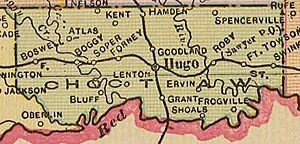
The St. Louis and San Francisco Railway built a train line through Hugo in 1902. This helped Hugo grow into an important business center. Before Oklahoma became a state, the area of Choctaw County was part of several Choctaw Nation counties. These included Jackson, Kiamichi, Cedar, and Towson counties. It also held two of the three main areas of the Choctaw Nation. These were the Apukshunnubbee District and the Pushmataha District.
As the time of Indian Territory ended, people living there wanted it to become a state. They suggested a new state called State of Sequoyah. This plan divided the lands of the five main tribes into counties. Hugo was chosen as the county seat for Hitchcock County in this plan. The U.S. Congress and president did not approve the State of Sequoyah. However, some of the county borders suggested for Sequoyah were later used for counties in Oklahoma.
In southeastern Oklahoma, the future Choctaw County's borders were mostly the same as Hitchcock County, Sequoyah. Also, the borders suggested for Pushmataha County, Sequoyah became the borders for Pushmataha County, Oklahoma. And McCurtain County, Oklahoma generally followed the borders of McCurtain County, Sequoyah. Both of these counties are next to Choctaw County.
When Oklahoma officially became a state in 1907, Choctaw County was created. Hugo was named its county seat.
Recent events
In October 2011, the U.S. Navy announced a special plan. They would name a ship after Choctaw County. This ship, a Joint High Speed Vessel (JHSV), would honor three American counties. These counties are named Choctaw County in Alabama, Mississippi, and Oklahoma. Secretary of the Navy Ray Mabus said he grew up in Choctaw County, Mississippi. He chose the name to honor people who represent rural America. The ship is called USNS Choctaw County and has the hull number JHSV-2.
Geography
Choctaw County is in southeastern Oklahoma. It is part of a 10-county area known as Choctaw Country for tourism. The U.S. Census Bureau says the county covers 800 square miles. About 770 square miles are land, and 29 square miles (3.7%) are water.
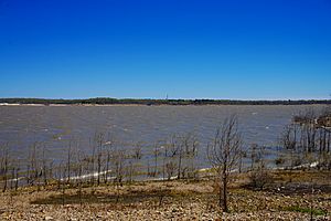
Important rivers in the county include the Kiamichi River, the Muddy Boggy River, and the Clear Boggy River. All of these rivers flow into the Red River. Lakes in the area are Hugo Lake, which is on the Kiamichi River, and Raymond Gary Lake. Choctaw County, along with McCurtain County, is the only part of Oklahoma where American alligators live naturally.
Major highways
Adjacent counties
- Pushmataha County (north)
- McCurtain County (east)
- Red River County, Texas (southeast)
- Lamar County, Texas (south)
- Bryan County (west)
- Atoka County (northwest)
Population Information
| Historical population | |||
|---|---|---|---|
| Census | Pop. | %± | |
| 1910 | 21,862 | — | |
| 1920 | 32,144 | 47.0% | |
| 1930 | 24,142 | −24.9% | |
| 1940 | 28,358 | 17.5% | |
| 1950 | 20,405 | −28.0% | |
| 1960 | 15,637 | −23.4% | |
| 1970 | 15,141 | −3.2% | |
| 1980 | 17,203 | 13.6% | |
| 1990 | 15,302 | −11.1% | |
| 2000 | 15,342 | 0.3% | |
| 2010 | 15,205 | −0.9% | |
| 2020 | 14,204 | −6.6% | |
| U.S. Decennial Census 1790-1960 1900-1990 1990-2000 2010 |
|||
In 2000, there were 15,342 people living in Choctaw County. There were 6,220 households and 4,285 families. The county had about 20 people per square mile. Most people (68.55%) were White. About 14.96% were Native American, and 10.94% were Black or African American. A small number of people were Asian or Pacific Islander. About 1.60% of the population were Hispanic or Latino. Most people (97.1%) spoke English at home.
About 30% of households had children under 18. Over half (51.30%) were married couples. The average household had 2.43 people. The average family had 2.96 people.
The population was spread out by age. About 26% were under 18 years old. About 17.4% were 65 years or older. The average age was 39 years.
Economy
Since Oklahoma became a state, farming, ranching, and cutting timber have been key parts of the county's economy. In 1910, cotton was the main crop. By 1930, farmers also grew corn, oats, hay, and peanuts. In the early 2000s, soybeans, vegetables, and corn were the main crops. Today, local stores and health care services are the biggest employers in the county.
Communities
City
- Hugo (county seat)
Towns
Census-designated places
Other unincorporated places
See also
 In Spanish: Condado de Choctaw (Oklahoma) para niños
 | Roy Wilkins |
 | John Lewis |
 | Linda Carol Brown |


