
Pushmataha District facts for kids
Quick facts for kids
Pushmataha
|
|
|---|---|

Chief Pushmataha, 1824, published in History of the Indian Tribes of North America.
|
|
The Pushmataha District was one of three main areas that made up the old Choctaw Nation in what is now the Indian Territory. It was also called the Third District. This district covered the southwestern part of the Choctaw lands.
The Pushmataha District was named after Pushmataha. He was a very respected Choctaw warrior and leader. Pushmataha was a chief of Okla Hannali, which means the Six Towns District. This was one of the three main groups of the Choctaw people in their original home in the Southeast. The other two districts were the Apukshunnubbee District and the Moshulatubbee District.
Contents
History of the Pushmataha District
How the Districts Started
These three districts were created when the Choctaw Nation moved to the Indian Territory. This move was a difficult journey known as the Trail of Tears. The districts were first meant to be homes for people from the three main Choctaw groups.
Over time, the old group connections became less important. This happened after the Choctaw arrived in the Indian Territory. The new land was different, and many people were lost during the move.
Changes in Power
The districts slowly became less important in the nation's government. The three district chiefs lost power. The main chief of the whole Choctaw Nation gained more power. Eventually, this main chief became the only political leader. He was no longer just "first among equals."
Justice in the Districts
Even though political power changed, the three districts kept their importance for legal matters. Serious problems that could not be solved at the local level were sent to the district courts. Court days were the busiest days of the year in the district centers.
District Headquarters
The final and most important main office for the Pushmataha District was in Mayhew, Indian Territory. This place started as a Presbyterian missionary station. Today, the town of Boswell, Oklahoma is about two miles south of where Mayhew was.
The first district office was at a place called Tiak Heli. This name meant "between the forks of the Boggy." It was located between two small rivers, Clear Boggy Creek and Muddy Boggy Creek. It was hard to get to because there were not many ways to cross the rivers.
When the courthouse at Tiak Heli burned down in the late 1800s, the district moved its main office to Mayhew. Today, Sunkist, Oklahoma is about half a mile west of where Tiak Heli used to be.
One early settler said, "I never understood why court was held in the forks of the Boggy, forcing everyone who attended to cross a river." He thought the location was probably chosen because it was in the middle of where most people lived. But he also said, "There were no ferries, nor bridges above the forks of the Boggy."
Another settler remembered a post oak tree that was used as the "whipping tree." Judges in the Choctaw district courts sometimes ordered whippings as a punishment. This tree was still there in 1937.
Counties in the District
The Pushmataha District included several Choctaw Nation counties. These were Atoka, Jack's Fork, Blue, Jackson, and Kiamitia (Kiamichi).
End of the District
As Oklahoma was about to become a state, the Pushmataha District and its counties slowly stopped their government work. The United States Courts in the Indian Territory took over their duties. On November 16, 1907, which was Oklahoma's Statehood Day, the district and its counties disappeared forever.
Images for kids
-
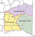
Pushmataha District covered the southwestern one-third of the Choctaw Nation.

Pushmataha District Today
The land that was once the Pushmataha District is now part of several Oklahoma counties. These include Atoka, Bryan, Choctaw, Coal, and Pushmataha.
