Moshulatubbee District facts for kids
Quick facts for kids
Moshulatubbee
|
|
|---|---|

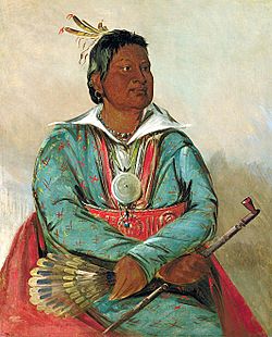
Mosholatubbee, painted by George Catlin
|
|
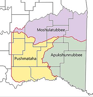
The Moshulatubbee District was a special area within the old Choctaw Nation. It was one of three main parts that made up the nation in the Indian Territory. This district was also known as the First District. It covered the northern one-third of the Choctaw Nation's land. Sometimes, you might see its name spelled as Mushulatubbe in old records.
This district was named after Chief Moshulatubbee. He was a brave Choctaw warrior and an important leader. Chief Moshulatubbee was once the chief of the Okla Tannap ("Lower Towns") District. This was back when the Choctaw Nation was still in the southeastern United States. Many Choctaw people from that time called the Moshulatubbee District by its older name, the Okla Tannap District. The two other main districts were called Apukshunnubbee and Pushmataha. They were also named after important Choctaw leaders.
Contents
History of the Moshulatubbee District
The Choctaw Nation created these districts when they moved to the Indian Territory. This big move is often called the Trail of Tears. The districts were first meant for different groups, or clans, of Choctaw people. But after the difficult move, these clan ties became less strong. Many people were lost during the hard journey.
Over time, the districts became less important in the nation's government. The chiefs who led these districts lost some of their power. The main leader of the entire Choctaw Nation became the most powerful. This leader was first called the governor, and later the principal chief. Eventually, this principal chief became the only main political leader.
District Courts and Government Seats
Even though their political power changed, the districts kept their importance in legal matters. Most smaller legal issues were handled at the county level. But more serious cases were always tried at the district level. Court days were very busy and important days in the district's main towns.
The Moshulatubbee District's main government office was at Gaines Court House. This place was also the county seat for Gaines County. Gaines Court House was located northeast of where McAlester, Oklahoma is today.
Counties of the District
The Moshulatubbee District included several Choctaw counties. These were Gaines, Sans Bois, Skullyville, Sugar Loaf, and Tobucksy.
End of the District Era
In the early 1900s, Oklahoma was getting ready to become a state. Because of this, the Moshulatubbee District and its counties slowly stopped their government work. The United States Courts in the Indian Territory began to take over their duties. On November 16, 1907, Oklahoma officially became a state. On that day, the districts and their counties no longer existed as active government areas.
Today, the land that was once the Moshulatubbee District is mostly part of several Oklahoma counties. These include Haskell, Hughes, Latimer, Le Flore, and Pittsburg.
 | Jackie Robinson |
 | Jack Johnson |
 | Althea Gibson |
 | Arthur Ashe |
 | Muhammad Ali |


