Skullyville County, Choctaw Nation facts for kids
Skullyville County was an important area for the Choctaw Nation in a place called Indian Territory. This was before Oklahoma became a state. It was part of the Choctaw Nation's Moshulatubbee District, which was one of their three main areas for managing things.
Contents
History of Skullyville County
What's in a Name?
The name Skullyville County came from the Choctaw words Iskvlli Kaunti. The word iskvlli means 'a small piece of money or coin'. (The letter "v" here sounds like a short "u".)
From 1832, Skullyville County was home to the United States agency for the Choctaws. This agency was about 15 miles west of Fort Smith. A village grew up around this agency and became known as Skullyville. This name is a mix of the Choctaw word iskulli and the English word -ville, meaning 'town'. So, Skullyville means 'money town'. The agency itself was called Iskvlli ai Ilhpita, which means 'the place where money is given'.
Early Settlement and Important Visitors
Skullyville town was settled around 1832. It became a landing spot for Choctaw people who arrived in the new Indian Territory. They came by steamboat during the "Trail of Tears". The steamboats used a landing on the south side of the Arkansas River. This spot had a large rock shelf.
Later, Skullyville town became the county seat, which is like the main town for county government. It even served as the capital of the Choctaw Nation for a time.
In 1834, the U.S. Army built and staffed Fort Coffee nearby. This fort helped protect the area from other Native American groups like the Wichita and Comanche.
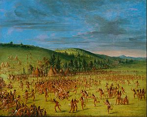
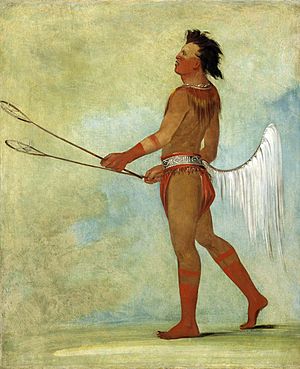
The same year, George Catlin, a famous American painter, visited Skullyville. He was known for painting Native Americans in the old West. Catlin painted Choctaw people playing stickball in Skullyville. His paintings and writings are the only descriptions we have of the Ball Play Dance and Eagle Dance from that time. Catlin showed the stickball game in a valley surrounded by the rolling hills of the Skullyville region.
How the County Was Formed
Skullyville County was one of the first 19 counties created by the Choctaw Nation's General Council in 1850. The county's borders were set using easy-to-spot natural landmarks. This was how all Choctaw Nation counties were defined.
For example, the Arkansas River formed the county's northern border. The state line of Arkansas was its eastern border. The western border followed a line from the mouth of Cashier Creek on the Arkansas River south to its source. From there, it went in a straight line to an area called the Narrows, near Red Oak. The county's southern border wound through valleys along Cavanal Mountain and nearby ridges. It followed Cedar Creek, Fourche Maline, and the Poteau River.
County Government and Leaders
The county was used as an election area for members of the National Council. It also served as a local government unit. The county had elected officials who served for two years. These included the county judge, sheriff, and a ranger.
The judge was in charge of how the county was run. The sheriff collected taxes and watched out for people who didn't belong there, usually white Americans. The sheriff also took the census, which counts the population. The county ranger was responsible for advertising and selling lost farm animals.
Skullyville County and Oklahoma Statehood
Changes for Statehood
As Oklahoma was getting ready to become a state, leaders met to plan the new state's counties. They realized that the Choctaw Nation's counties, though well-designed, might not work as separate economic areas. In most Choctaw counties, the county seat was mainly for court and not a big population center.
Skullyville County was a bit different. It had busy towns along several railroad lines, especially Poteau. But even with its growth, it would still need to change to fit the new state's plans.
The State of Sequoyah Proposal
In 1905, leaders met to propose a new state called State of Sequoyah for the Indian Territory. This group also suggested a county structure that would get rid of the Choctaw counties. Skullyville County would have been split mainly into two proposed counties: Thomas County and Rutherford County.
Stigler and Bokoshe would have been the main towns in Thomas County. The busy railroad towns of Poteau, Spiro, and Wister would have been the main towns in Rutherford County.
However, when Oklahoma officially became a state two years later, its leaders chose a very different county system. The land that was once Skullyville County now mostly falls within Le Flore, Haskell, and Latimer counties. Skullyville County stopped existing when Oklahoma became a state on November 16, 1907.
 | Janet Taylor Pickett |
 | Synthia Saint James |
 | Howardena Pindell |
 | Faith Ringgold |


