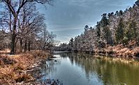
Fourche Maline (Oklahoma stream) facts for kids
Fourche Maline (pronounced "foosh-ma-lean") is a river in Oklahoma. Its name comes from French and means "Bad Fork" or "treacherous fork." This river is about 70 miles (113 km) long and flows into the Poteau River.
The Fourche Maline starts in the Sans Bois Mountains in northwest Latimer County. It then flows southwest through Robbers Cave State Park. After that, it turns southeast past Wilburton before heading east. Finally, it joins the Poteau River in Le Flore County. The spot where it meets the Poteau River is now underwater in Lake Wister. This is about 6 miles (9.7 km) south of where they used to meet. The total distance from where the river begins to where it joins the Poteau River is about 37 miles (60 km).
Long ago, during the time of the Indian Territory, the Fourche Maline was an important boundary. It separated two areas called Skullyville County and Sugar Loaf County. These areas were part of the Moshulatubbee District of the Choctaw Nation.
Fish and Fishing in Fourche Maline
The Fourche Maline is home to many different kinds of fish. You can find fish like walleye, bream, bluegill, catfish, smallmouth bass, carp, and rainbow trout here. This river is located about 5.3 miles (8.5 km) from Wister, making it a popular spot for fishing.
Trout Fishing Opportunities
A special part of the Fourche Maline, about 1.5 miles (2.4 km) long, is known for rainbow trout. This section is downstream from Carlton Lake Dam to the southern edge of Robbers Cave Park.
The state of Oklahoma helps keep the trout population healthy by adding new trout to the river every winter. This "stocking" season usually starts on November 1st and ends on March 15th. However, it's good to know that rainbow trout often don't do well in Oklahoma's hot summer weather.
 | Isaac Myers |
 | D. Hamilton Jackson |
 | A. Philip Randolph |


