Fort Towson, Oklahoma facts for kids
Quick facts for kids
Fort Towson, Oklahoma
|
|
|---|---|

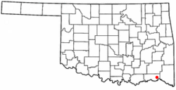
Location of Fort Towson, Oklahoma
|
|
| Country | United States |
| State | Oklahoma |
| County | Choctaw |
| Area | |
| • Total | 5.99 sq mi (15.51 km2) |
| • Land | 5.62 sq mi (14.56 km2) |
| • Water | 0.37 sq mi (0.95 km2) |
| Elevation | 509 ft (155 m) |
| Population
(2020)
|
|
| • Total | 492 |
| • Density | 87.50/sq mi (33.78/km2) |
| Time zone | UTC-6 (Central (CST)) |
| • Summer (DST) | UTC-5 (CDT) |
| ZIP code |
74735
|
| Area code(s) | 580 |
| FIPS code | 40-27400 |
| GNIS feature ID | 24126449 |
Fort Towson is a small town located in Choctaw County, Oklahoma, in the United States. In 2020, about 492 people lived there. The town is named after a nearby fort, which was built in 1824. This fort was named after General Nathan Towson, a hero from the War of 1812. The town of Fort Towson was officially started in 1902. This happened after the Arkansas and Choctaw Railway built train tracks through the eastern part of Choctaw County.
Contents
History of Fort Towson
Early Days of the Fort
The original fort was built to protect the southern border of the Indian Territory. This area was close to Spanish colonies. Later, after the Indian Removal policy, the Choctaw people moved to this area. The fort was then used again to protect Doaksville, a town about a mile away. Doaksville became an important center for the Choctaw Nation's economy. Fort Towson Landing was a key spot on the Red River. It was where boats could travel, making it a busy trading place.
Fort Towson During the Civil War
During the American Civil War, the Choctaw Nation joined forces with the Confederacy. In June 1865, Chief Peter Pitchlynn surrendered on behalf of the Choctaw people. Fort Towson is famous for being the place where the very last Confederate land forces gave up. On June 23, 1865, Brigadier General Stand Watie, a Cherokee chief, agreed to end the fighting. He led his Choctaw Battalion out of the war.
Modern Changes and Growth
In the 1950s, Raymond Gary Lake and Raymond Gary State Park were created near the town. These new attractions brought more people to the area. In 1979, Fort Towson's town limits were made larger to include the people living near the lake. Because of this, the town's population grew quite a bit by the 1980 census.
Geography and Location
Fort Towson is located about 11 miles (18 km) east of Hugo. The town covers a total area of about 5.9 square miles (15.5 square kilometers). Most of this area, about 5.6 square miles (14.6 square kilometers), is land. The rest, about 0.4 square miles (0.95 square kilometers), is water.
Population Over Time
| Historical population | |||
|---|---|---|---|
| Census | Pop. | %± | |
| 1910 | 697 | — | |
| 1920 | 965 | 38.5% | |
| 1930 | 486 | −49.6% | |
| 1940 | 501 | 3.1% | |
| 1950 | 713 | 42.3% | |
| 1960 | 474 | −33.5% | |
| 1970 | 430 | −9.3% | |
| 1980 | 789 | 83.5% | |
| 1990 | 568 | −28.0% | |
| 2000 | 611 | 7.6% | |
| 2010 | 519 | −15.1% | |
| 2020 | 492 | −5.2% | |
| U.S. Decennial Census | |||
In 2000, Fort Towson had 611 people living in 255 households. About 28.6% of these households had children under 18. Most households (55.7%) were married couples. The town's population was made up of different groups. About 86% were White, 8% were Native American, and about 1% were African American. A small number of people were Asian or from other backgrounds. About 2.3% of the population was Hispanic or Latino. The average age in Fort Towson was 42 years old.
Historic Places to Visit
Several places near Fort Towson are listed on the National Register of Historic Places. This means they are important historical sites.
- Doaksville Site
- Fort Towson
- Spencer Academy
- Willie W. Wilson House
Notable People from Fort Towson
- Frank Abercrombie, a professional baseball player.
See also
 In Spanish: Fort Towson (Oklahoma) para niños
 | Sharif Bey |
 | Hale Woodruff |
 | Richmond Barthé |
 | Purvis Young |


