Choctaw Country facts for kids
Choctaw Country is a special area in Southeastern Oklahoma. It's named by the Oklahoma Department of Tourism and Recreation to help people explore the region. This name honors the Choctaw Nation, whose main offices are located here.
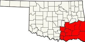
Choctaw Country includes ten counties: Coal, Atoka, Bryan, Choctaw, McCurtain, Pushmataha, Le Flore, Latimer, Haskell, and Pittsburg. It's one of six special travel areas in Oklahoma.
The area was once called Kiamichi Country. French explorers gave it this name in the early 1700s. They saw a loud woodpecker they called Kiamichi, meaning "raucous bird." This name also stuck to the Kiamichi Mountains.
After the American Civil War, many people moved here from the South. This made Choctaw Country feel more like the southern United States. Because of this, it was also known as "Little Dixie".
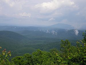
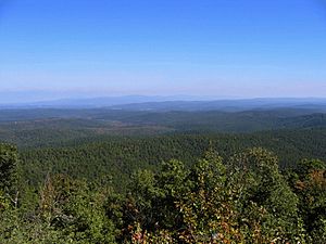
Choctaw Country is not very crowded. It has many mountains and thick forests. This makes it a great place for outdoor fun. You can enjoy water sports, mountain biking, hiking, hunting, and fishing. The Choctaw Nation has a large area of influence here.
Contents
A Look Back: History of Choctaw Country
After the United States bought this land from France in 1803, it became part of the Arkansas Territory. In 1820, a large part of what is now Choctaw Country was called Miller County.
At this time, the U.S. government wanted to move Native American tribes. They wanted to open up tribal lands in the Southeast for new settlers. The Five Civilized Tribes, including the Choctaw, faced a lot of pressure.
Some Choctaw people had already moved to this region from Mississippi. This started after the Treaty of Doak's Stand in 1820. In 1825, the U.S. signed a treaty with the Choctaw. This treaty gave the Choctaw land west of Fort Smith.
In 1830, the Indian Removal Act was passed. The Treaty of Dancing Rabbit Creek then forced many Choctaw to leave their homes. By 1834, almost 8,000 Choctaw had arrived in their new land. This difficult journey was known as the "trail of tears and death." They built a capital at Nanih Waiya and wrote the first constitution in what is now Oklahoma.
During the American Civil War, the Choctaw supported the Confederacy. After the war, they were allowed to keep most of their land. Later, in 1898, the Dawes Commission divided their lands. Extra lands were then opened for non-Native American settlers.
Many people from the South moved to this area. They were looking for new chances after the Civil War. These new settlers greatly shaped the culture and politics of the region. This is how southeastern Oklahoma became known as Little Dixie.
Exploring the Geography
Southeastern Oklahoma is very different from other parts of the state. It has many mountains and thick forests. Here you'll find most of the Ouachita Mountains in Oklahoma. You can also see the Arbuckle Mountains and five other mountain ranges. The Ouachita National Forest, Oklahoma's only national forest, is also in this area.
Choctaw Country is home to "The World's Highest Hill." This peak near Poteau is 1,999 feet tall. A "mountain" is officially 2,000 feet or taller.
The region also has Oklahoma's largest lake, Lake Eufaula. Other big lakes include Robert S. Kerr Reservoir, Sardis Lake, Hugo Lake, McGee Creek Reservoir, Pine Creek Lake, Broken Bow Lake, Lake Wister, Lake Atoka Reservoir, and Lake Texoma.
Understanding the Politics
The people in this region have mostly voted for the Democratic Party. Many call themselves yellow-dog Democrats. This means they would vote for a yellow dog if it was a Democrat. However, more and more voters are now joining the Republican Party.
From when Oklahoma became a state until 2003, most of this region was in its own Congressional district. Carl Albert from McAlester was a very famous congressman from this area. He served for 30 years and was even the Speaker of the House. He was known as the Little Giant from Little Dixie.
After Carl Albert retired, Wes Watkins took his place. He was the first Republican to win this seat since Oklahoma became a state. This win helped other Republicans get elected in the region.
After the 2000 U.S. Census, Oklahoma lost one seat in Congress. Most of the Little Dixie region joined northeastern Oklahoma. It became part of Oklahoma's 2nd congressional district. The area still has many Democrats. But many of them are conservative, meaning they hold traditional values.
Donald Trump, a Republican, won the region in the 2016 election. He also won the Native American vote in Choctaw Country. This was likely because his ideas about limited government appealed to many voters.
Fun for Visitors: Tourism
Choctaw Country calls itself the "Deer Capital of the World." It's a great place for tourists. You can enjoy scenic drives through the Ouachita Mountains. There are 13 major lakes for water fun. You can also visit the Chickasaw National Recreation Area and state parks. Whitewater rapids sports are also popular. The Talimena Scenic Drive is a famous road. It takes you through the Ouachita National Forest in the Winding Stair Mountains.
People and Population: Demographics
In 2000, about 305,395 people lived in Choctaw Country. About 76% were White, and over 17% were American Indian. Nearly 4% were Black. Many Black residents are descendants of Choctaw freedmen. These were enslaved people freed after the Civil War. Some have mixed Choctaw and African-American family backgrounds. The average income per person in the region was $13,948. This was less than the state average of $23,517.
Cities and Towns to Explore
The city of McAlester is the main city in the region. Durant is another important city to the south. It is one of the fastest-growing cities in the United States.
Other key cities and towns include Atoka, Poteau, Hugo, Idabel, Broken Bow, Talihina, Clayton, Antlers, Coalgate, Wilburton and Watson.
 | Precious Adams |
 | Lauren Anderson |
 | Janet Collins |


