Coalgate, Oklahoma facts for kids
Quick facts for kids
Coalgate, Oklahoma
|
|
|---|---|

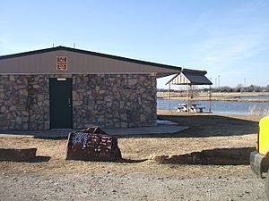
A park in the south part of Coalgate
|
|

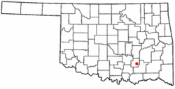
Location of Coalgate, Oklahoma
|
|
| Country | United States |
| State | Oklahoma |
| County | Coal |
| Area | |
| • Total | 1.86 sq mi (4.81 km2) |
| • Land | 1.82 sq mi (4.70 km2) |
| • Water | 0.04 sq mi (0.10 km2) |
| Elevation | 614 ft (187 m) |
| Population
(2020)
|
|
| • Total | 1,667 |
| • Density | 917.95/sq mi (354.41/km2) |
| Time zone | UTC-6 (Central (CST)) |
| • Summer (DST) | UTC-5 (CDT) |
| ZIP code |
74538
|
| Area code(s) | 580 |
| FIPS code | 40-15800 |
| GNIS feature ID | 2409494 |
Coalgate is a city in Oklahoma, United States. It is the main town, or county seat, of Coal County. In 2020, about 1,667 people lived there.
The town started in 1889 as a coal mining camp. It was first called Liddle. The name changed to Coalgate on January 23, 1890.
Contents
History of Coalgate
Coalgate began in 1889 as a mining camp. It was in the Choctaw Nation, Indian Territory. The camp was named Liddle after William "Bill" Liddle. He was a manager for a coal company. He came in 1888 to find a good spot for a new mine.
Early Days and Coal Mining
The Southwestern Coal and Improvement Company helped build the town. This company was part of the Missouri, Kansas and Texas Railway. First, there was a camp with tents. Then, houses were built for the workers. Mining started on January 2, 1889. The first coal was shipped out on April 17, 1889.
The town's name changed to Coalgate on January 23, 1890. The new name came from a steel gate. This "coal gate" separated the trains from the mines. Coalgate officially became a town in 1898.
Becoming the County Seat
Coal County was created in 1907. At first, Lehigh, Oklahoma was chosen as the county seat. This means it was the main town for the county government. But in 1908, people voted to move the county seat to Coalgate.
By 1907, Coalgate had grown to 2,921 people. A year later, it had about 3,500 residents. The city had many businesses. These included at least 65 stores, doctors, and even newspapers. In 1912, the streets downtown were paved with bricks. The local newspaper, Coalgate Record Register, started in 1911.
Challenges and Changes
Coalgate faced a big challenge in 1917. On June 1, an F4 tornado hit the city. An F4 tornado is very strong. It destroyed the Westward school and over 200 homes. At least 11 people died.
The city did well until the 1920s. Then, the coal mines closed because of worker strikes. After this, farming and manufacturing became the main jobs. From 1921 to 1923, tiny bugs called boll weevils ruined cotton crops. All five banks in the county closed. Coalgate's population was highest in 1920, with 3,009 people. It has not reached that number since.
Coalgate made it through the Great Depression. Many businesses struggled, but the city survived. Government programs like the Civilian Conservation Corps helped the economy. World War II brought a short boost to the coal industry. But by 1958, all the mines had closed for good.
Geography
Coalgate is about 1.6 square miles (4.8 square kilometers) in total area. Most of this area is land. A small part, about 0.04 square miles (0.10 square kilometers), is water.
Population Changes
| Historical population | |||
|---|---|---|---|
| Census | Pop. | %± | |
| 1900 | 2,614 | — | |
| 1910 | 3,255 | 24.5% | |
| 1920 | 3,009 | −7.6% | |
| 1930 | 2,064 | −31.4% | |
| 1940 | 2,118 | 2.6% | |
| 1950 | 1,984 | −6.3% | |
| 1960 | 1,689 | −14.9% | |
| 1970 | 1,859 | 10.1% | |
| 1980 | 2,001 | 7.6% | |
| 1990 | 1,895 | −5.3% | |
| 2000 | 2,005 | 5.8% | |
| 2010 | 1,967 | −1.9% | |
| 2020 | 1,667 | −15.3% | |
| U.S. Decennial Census | |||
In 2000, there were 2,005 people living in Coalgate. There were 830 households, which are groups of people living together. About 498 of these were families.
The population was spread out by age. About 26.2% of people were under 18. About 22.1% were 65 or older. The average age was 38 years old.
The average money earned by a household in 2000 was $19,419. For families, it was $26,367. About 28.6% of all people in Coalgate lived below the poverty line. This means they had very little money.
Transportation
Four main highways pass through Coalgate.
- U.S. Route 75 and Oklahoma State Highway 3 run together, going north and south.
- Oklahoma State Highway 43 goes east from Coalgate.
- Oklahoma State Highway 31 also goes through the northern part of Coalgate.
Notable People from Coalgate
- Josh Brecheen (born 1979): He is a citizen of the Choctaw Nation. Since 2023, he has been a U.S. representative for Oklahoma.
- Patrick J. Hurley (1883–1963): He was an American general and diplomat. He grew up near Coalgate.
See also
 In Spanish: Coalgate (Oklahoma) para niños
 | Ernest Everett Just |
 | Mary Jackson |
 | Emmett Chappelle |
 | Marie Maynard Daly |

