Lehigh, Oklahoma facts for kids
Quick facts for kids
Lehigh, Oklahoma
|
|
|---|---|

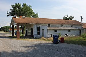
Owl Grocery in Lehigh, 2012
|
|

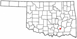
Location of Lehigh, Oklahoma
|
|
| Country | United States |
| State | Oklahoma |
| County | Coal |
| Area | |
| • Total | 1.62 sq mi (4.20 km2) |
| • Land | 1.57 sq mi (4.07 km2) |
| • Water | 0.05 sq mi (0.14 km2) |
| Elevation | 600 ft (200 m) |
| Population
(2020)
|
|
| • Total | 272 |
| • Density | 173.14/sq mi (66.84/km2) |
| Time zone | UTC-6 (Central (CST)) |
| • Summer (DST) | UTC-5 (CDT) |
| ZIP code |
74556
|
| Area code(s) | 580 |
| FIPS code | 40-42200 |
| GNIS feature ID | 2410817 |
Lehigh is a small city in Coal County, Oklahoma, in the United States. In 2010, its population was 356 people. By 2020, the population was 272.
Contents
History of Lehigh
Lehigh started as the very first mining camp in the area that is now Coal County, Oklahoma. When it was founded, it was part of Atoka County, Choctaw Nation. The town was first called Boone. Later, its name was changed to Lehigh. This new name came from Lehigh County, Pennsylvania, which was also a big coal-mining area.
A post office opened in Lehigh, Indian Territory, on April 4, 1882. Several railroads built train lines to Lehigh. These included the Missouri–Kansas–Texas Railroad, the Chicago, Rock Island and Pacific Railway, and the Gulf, Colorado and Santa Fe Railway. Besides mining, raising cattle and other animals was also very important to the local economy. Stockyards, which are places where animals are kept before being shipped, were built in 1884. Even before they were finished, 23 train cars of cattle and seven cars of hogs were ready to be shipped.
In the late 1800s and early 1900s, Lehigh was a growing town. It made a lot of money from the coal mines around it. However, in the 1910s and 1920s, people needed less coal. This was because trains started using oil for power instead of coal. Eventually, the coal mines closed down. In the early 1920s, tiny insects called boll weevils destroyed the cotton crops in the area. Many businesses in Lehigh closed, and people started to leave the town. Today, the Merchants National Bank Building is the only building left from the busy downtown area Lehigh once had.
Geography of Lehigh
Lehigh is located in the southeastern part of Coal County. U.S. Route 75 goes through the city. This road leads north about 5 miles (8 km) to Coalgate, which is the main town of the county. It also leads southeast about 9 miles (14 km) to Atoka.
The United States Census Bureau is a government agency that collects information about people and places. According to them, the city of Lehigh covers a total area of 1.6 square miles (4.1 km2). A small part of this area, about 0.04 square miles (0.10 km2), is covered by water.
Climate in Lehigh
| Climate data for Lehigh, Oklahoma | |||||||||||||
|---|---|---|---|---|---|---|---|---|---|---|---|---|---|
| Month | Jan | Feb | Mar | Apr | May | Jun | Jul | Aug | Sep | Oct | Nov | Dec | Year |
| Mean daily maximum °F (°C) | 49.2 (9.6) |
54.6 (12.6) |
63.9 (17.7) |
73.5 (23.1) |
79.6 (26.4) |
87.4 (30.8) |
93.4 (34.1) |
94.1 (34.5) |
85.7 (29.8) |
75.7 (24.3) |
63.4 (17.4) |
52.9 (11.6) |
72.8 (22.7) |
| Mean daily minimum °F (°C) | 27.0 (−2.8) |
31.4 (−0.3) |
40.6 (4.8) |
50.2 (10.1) |
58.5 (14.7) |
66.6 (19.2) |
71.0 (21.7) |
70.1 (21.2) |
63.0 (17.2) |
51.3 (10.7) |
40.9 (4.9) |
30.9 (−0.6) |
50.1 (10.1) |
| Average precipitation inches (mm) | 2.0 (51) |
2.5 (64) |
3.6 (91) |
4.6 (120) |
5.3 (130) |
4.2 (110) |
2.5 (64) |
2.5 (64) |
4.8 (120) |
3.7 (94) |
3.2 (81) |
2.3 (58) |
41.3 (1,050) |
| Source 1: weather.com | |||||||||||||
| Source 2: Weatherbase.com | |||||||||||||
People in Lehigh
| Historical population | |||
|---|---|---|---|
| Census | Pop. | %± | |
| 1900 | 1,500 | — | |
| 1910 | 1,880 | 25.3% | |
| 1920 | 1,898 | 1.0% | |
| 1930 | 497 | −73.8% | |
| 1940 | 519 | 4.4% | |
| 1950 | 352 | −32.2% | |
| 1960 | 296 | −15.9% | |
| 1970 | 296 | 0.0% | |
| 1980 | 284 | −4.1% | |
| 1990 | 303 | 6.7% | |
| 2000 | 315 | 4.0% | |
| 2010 | 356 | 13.0% | |
| 2020 | 272 | −23.6% | |
| U.S. Decennial Census | |||
In 2000, there were 315 people living in Lehigh. These people made up 114 households, and 77 of these were families. The city had about 199.9 people per square mile (77.2 per km2).
Out of the 114 households, almost 30% had children under 18 living there. More than half (50.9%) were married couples. About 10.5% were led by a woman without a husband present. About 24.6% of all households were single people living alone. The average household had 2.76 people.
The people in Lehigh came from different backgrounds. About 76.5% were White, 0.95% were African American, and 14.9% were Native American. About 0.95% were Asian, and 6.67% were from two or more races. About 1.27% of the population was Hispanic or Latino.
The ages of people in Lehigh varied. About 28.9% were under 18 years old. About 9.2% were between 18 and 24. People aged 25 to 44 made up 26.7%. Those between 45 and 64 were 21.3%. Finally, 14.0% of the population was 65 years or older. The average age in the city was 35 years.
The average income for a household in Lehigh was $24,167. For families, the average income was $25,156. The average income for each person was $10,699. About 18.8% of families and 27.7% of all people lived below the poverty line. This included 37.8% of children under 18 and 12.5% of people 65 or older.
Notable people from Lehigh
- Rube Foster: A baseball player who won the World Series with the Boston Red Sox in 1915 and 1916.
- Patrick J. Hurley: He served as the U.S. Secretary of War from 1929 to 1933.
- Benjamin Franklin Smallwood: He was the main leader, or principal chief, of the Choctaw Nation from 1888 to 1890.
- Muriel Hazel Wright: A famous historian who was born in Lehigh in 1889.
See also
 In Spanish: Lehigh (Oklahoma) para niños
 | Tommie Smith |
 | Simone Manuel |
 | Shani Davis |
 | Simone Biles |
 | Alice Coachman |

