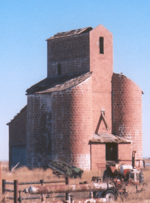
This cool grain elevator was built around 1920 near
Ingersoll.
In Oklahoma, some towns and communities don't have their own official city government. These are called unincorporated communities. Instead of having a mayor or a city council, the people living there rely on the county government for services like roads and law enforcement.
Sometimes, a community used to have its own government but doesn't anymore. This can happen for many reasons. For example, during the 1930s and 1940s, many people moved away from these areas, causing some towns to shrink or even disappear. In Oklahoma, a town can lose its government if it asks to, or if it misses two local elections in a row. Communities that have an official map, called a plat, have some special rights that other communities without such a map don't. Having a plat is also one of the things needed if a community wants to form its own government again.
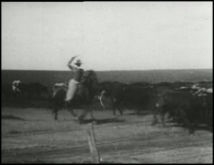
Driving Cattle to Pasture near
Bliss in 1904.
Even without a city government, these communities can still organize important services. They might set up their own water systems or fire departments and collect money from residents to pay for them. Many also have their own school districts with elected school boards, which means local people make decisions about their schools. Some unincorporated communities even have their own post offices, helping connect residents to the rest of the world.
Many unincorporated communities played a big part in Oklahoma's history. Places like Boggy Depot, Tuskahoma, and Skullyville were important as Oklahoma grew. Today, many of these communities, especially those with schools and post offices, are still important centers for people living in the countryside.
This list of communities comes from the Oklahoma Almanac, published by the Oklahoma Department of Libraries. Other communities have been added using information from Wikipedia, which uses reliable sources. If a place isn't likely to be a community, its exact location (geographic coordinates) is often provided.
List of Unincorporated Communities in Oklahoma
This is a list of many unincorporated communities in Oklahoma. Some of these places are still active, while others might be very small or even abandoned.
Communities Starting with A
Communities Starting with B
Communities Starting with C
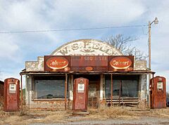
This old gas station and store in
Cogar was used in the movie
Rainman.
|
Community |
County |
Notes |
|
Cade |
Bryan |
|
|
Calhoun |
Le Flore |
|
|
Canadian Shores |
Pittsburg |
|
|
Cogar |
Caddo |
|
|
Cookson |
Cherokee |
|
Communities Starting with D
Communities Starting with E
Communities Starting with F
Communities Starting with G
|
Community |
County |
Notes |
|
Garden Grove |
Pottawatomie |
|
|
Garland |
Haskell |
|
|
Gideon |
Cherokee |
|
|
Glover |
McCurtain |
|
|
Grant |
Choctaw |
|
Communities Starting with H
Communities Starting with I
Communities Starting with J
|
Community |
County |
Notes |
|
Jacktown |
Lincoln |
|
|
Jesse |
Pontotoc |
|
|
Jimtown |
Love |
|
|
Jollyville |
Murray |
|
|
Jumbo |
Pushmataha |
|
Communities Starting with K
|
Community |
County |
Notes |
|
Keefeton |
Muskogee |
|
|
Kengle |
Tulsa |
|
|
Kenton |
Cimarron |
|
|
Kenwood |
Delaware |
|
|
Kusa |
Okmulgee |
|
Communities Starting with L
|
Community |
County |
Notes |
|
Lacey |
Kingfisher |
|
|
Lafayette |
Haskell |
|
|
Lane |
Atoka |
|
|
Lebanon |
Marshall |
|
|
Leonard |
Tulsa |
|
Communities Starting with M
Salt was an important product made near
McKey a long time ago.
|
Community |
County |
Notes |
|
McKey |
Sequoyah |
|
|
McLain |
Muskogee |
|
|
Madge |
Harmon |
|
|
Mason |
Okfuskee |
|
|
Meers |
Comanche |
|
Communities Starting with N
Communities Starting with O
Communities Starting with P
Communities Starting with Q
Communities Starting with R
|
Community |
County |
Notes |
|
Raiford |
McIntosh |
|
|
Reagan |
Johnston |
|
|
Red Fork |
Tulsa |
|
|
Richland |
Canadian |
|
|
Rose |
Mayes |
|
Communities Starting with S
Communities Starting with T
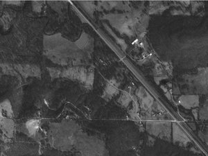
This aerial view shows
Tiawah in the Tiawah Hills along State Highway 88.
Communities Starting with U
|
Ulan |
Pittsburg |
|
|
Ultima Thule |
McCurtain |
|
|
Utica |
Bryan |
|
Communities Starting with V
|
Community |
County |
Notes |
|
Vamoosa |
Seminole |
|
|
Vanoss |
Pontotoc |
|
|
Victory |
Jackson |
|
|
Vinson |
Harmon |
|
|
Vivian |
McIntosh |
|
Communities Starting with W
Communities Starting with Y
Communities Starting with Z
|
Community |
County |
Notes |
|
Zafra |
Le Flore |
|
|
Zaneis |
Carter |
|
|
Zena |
Delaware |
|
|
Zincville |
Ottawa |
|
|
Zoe |
Le Flore |
|


