Proctor, Oklahoma facts for kids
Quick facts for kids
Proctor, Oklahoma
|
|
|---|---|

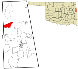
Location within Adair County and the state of Oklahoma
|
|
| Country | United States |
| State | Oklahoma |
| County | Adair |
| Area | |
| • Total | 10.80 sq mi (27.97 km2) |
| • Land | 10.71 sq mi (27.73 km2) |
| • Water | 0.09 sq mi (0.23 km2) |
| Elevation | 981 ft (299 m) |
| Population
(2020)
|
|
| • Total | 180 |
| • Density | 16.81/sq mi (6.49/km2) |
| Time zone | UTC-6 (Central (CST)) |
| • Summer (DST) | UTC-5 (CDT) |
| Zip code |
74457
|
| FIPS code | 40-60750 |
| GNIS feature ID | 2584390 |
Proctor is a small community located in Adair County, Oklahoma, in the United States. It is known as a census-designated place (CDP). This means it's an area that the government counts for population, but it doesn't have its own official city government.
In 2010, about 231 people lived in Proctor. By the year 2020, the population was 180.
Proctor's Location and Landscape
Proctor is nestled in a valley. This valley is near the Baron Fork, which is a stream. The Baron Fork flows into the Illinois River in Oklahoma.
A major road, U.S. Route 62, runs right through the middle of Proctor. If you travel east on this road for about 13 miles (21 kilometers), you will reach the town of Westville. If you go west for about 14 miles (23 kilometers), you will arrive in Tahlequah.
The total area of Proctor is about 10.80 square miles (27.97 square kilometers). Most of this area is land. Only a small part, about 0.09 square miles (0.23 square kilometers), is water.
Proctor's Population Changes
The number of people living in Proctor has changed over time. The United States Census Bureau collects this information.
| Historical population | |||
|---|---|---|---|
| Census | Pop. | %± | |
| 2020 | 180 | — | |
| U.S. Decennial Census | |||
In 2010, the census counted 231 people living in Proctor. By the time of the 2020 census, the population had changed to 180 people.
See also
 In Spanish: Proctor (Oklahoma) para niños
 | Emma Amos |
 | Edward Mitchell Bannister |
 | Larry D. Alexander |
 | Ernie Barnes |

