
Tahlequah, Oklahoma facts for kids
Quick facts for kids
Tahlequah
ᏓᎵᏆ (Cherokee)
|
|
|---|---|
| City of Tahlequah | |

Downtown Tahlequah
|
|
| Motto(s):
"City of Firsts"
|
|

Location within Cherokee County and the state of Oklahoma
|
|

Tahlequah
Location in Oklahoma

Tahlequah
Location in the United States
|
|
| Country | |
| State | |
| County | Cherokee |
| Cherokee Nation | founded 1838; second capital city |
| Area | |
| • Total | 12.87 sq mi (33.33 km2) |
| • Land | 12.77 sq mi (33.06 km2) |
| • Water | 0.10 sq mi (0.27 km2) |
| Elevation | 814 ft (248 m) |
| Population
(2020)
|
|
| • Total | 16,209 |
| • Density | 1,269.70/sq mi (490.24/km2) |
| Time zone | UTC-6 (Central (CST)) |
| • Summer (DST) | UTC-5 (CDT) |
| ZIP codes |
74464-74465
|
| Area code(s) | 539/918 |
| FIPS code | 40-72100 |
| GNIS feature ID | 2412028 |
Tahlequah is a city in Cherokee County, Oklahoma. It sits at the base of the Ozark Mountains. This city is a very important place for the Cherokee people. It was chosen as the capital of the Cherokee Nation in 1839. This happened after many Cherokee people were forced to move west from their homes in the American Southeast. This difficult journey is known as the Trail of Tears.
Tahlequah is the official capital for two important Cherokee tribes in Oklahoma today. These are the modern Cherokee Nation and the United Keetoowah Band of Cherokee Indians. It is also the main city, or county seat, of Cherokee County. You can find the main campus of Northeastern State University here too. In 2020, about 16,209 people lived in Tahlequah.
Contents
History of Tahlequah
Early Cherokee Capitals
Before Tahlequah, another place called Tahlonteeskee was the first Cherokee capital in what is now Oklahoma. It was set up in 1828. But after the Trail of Tears, many more Cherokee people arrived. So, in 1839, the capital moved to Tahlequah. By 1840, Tahlequah was officially the center of the Cherokee government.
Growing as a City
Tahlequah grew quickly. By 1842, it had four stores. In 1843, the town area was measured out. That same year, a big meeting of 21 different Native American tribes happened here. About ten thousand people came!
In 1844, the National Hotel was built. The first newspaper, Cherokee Advocate, started printing in the new Supreme Court building. A school opened in 1845, and the post office in 1847. The Cherokee Male Seminary, a college for boys, opened in 1851.
What Does "Tahlequah" Mean?


Many language experts think the name 'Tahlequah' comes from the Cherokee word 'di li gwa'. This word means "grain" or "rice." It might refer to a red-colored native grain that grew in open fields in eastern Tennessee.
There's also a local story about the name. It says three tribal elders planned to meet to pick the capital city. Only two arrived. As it got dark, they decided "two is enough," or 'ta-li-ye-li-quu' in Cherokee. This phrase supposedly became 'Tahlequah'. However, this story likely started much later, around the 1930s. Tahlequah was a settlement even before it became the capital.
Tahlequah as the Cherokee Capital
In 1839, Tahlequah became the capital for the ancestors of both the Cherokee Nation and the United Keetoowah Band. At first, the government buildings were made of logs or wood. Sadly, many were destroyed during the American Civil War. During this war, the Cherokee people were divided.
The Cherokee Supreme Court Building was built in 1844. It is the oldest public building in Oklahoma. You can still see it in downtown Tahlequah.
Around town, you'll notice signs in both English and the Cherokee language. These signs use the unique Cherokee syllabary. This writing system was created by a Cherokee scholar named Sequoyah in the 1820s.
After the Civil War
After the Civil War, a new brick capitol building was finished in 1870. In 1907, when Oklahoma became a state, this building became the Cherokee County courthouse. It was given back to the Cherokee Nation in 1970.
In 1886, the first telephone company in the area was built in Tahlequah. The Cherokee Female Seminary, a college for girls, was rebuilt in Tahlequah after a fire in 1887. Later, it became Northeastern State University. The first bank in the Cherokee Nation opened here in 1891.
A large fire destroyed many wooden buildings in downtown Tahlequah in 1895. They were replaced with stronger brick buildings. In 1902, a railway line was built into Tahlequah, helping it grow even more. Tahlequah was one of the fastest-growing cities in Oklahoma during the 1990s.
Geography and Climate
Tahlequah's Location
Tahlequah covers about 12.45 square miles (32.2 square kilometers) of land. It is located about 40 miles (64 kilometers) west of the Arkansas state line.
Weather in Tahlequah
Tahlequah has a humid subtropical climate. This means it has hot and humid summers. Springs and autumns are usually warm but can change a lot. Winters are cool with many frosts. Sometimes, very cold and dry air from Canada can bring severe weather.
| Climate data for Tahlequah 1981-2010, extremes 1900-2008 | |||||||||||||
|---|---|---|---|---|---|---|---|---|---|---|---|---|---|
| Month | Jan | Feb | Mar | Apr | May | Jun | Jul | Aug | Sep | Oct | Nov | Dec | Year |
| Record high °F (°C) | 78 (26) |
88 (31) |
96 (36) |
94 (34) |
97 (36) |
108 (42) |
118 (48) |
118 (48) |
109 (43) |
98 (37) |
89 (32) |
80 (27) |
118 (48) |
| Mean daily maximum °F (°C) | 49.0 (9.4) |
54.0 (12.2) |
63.4 (17.4) |
72.1 (22.3) |
78.5 (25.8) |
85.5 (29.7) |
90.8 (32.7) |
91.5 (33.1) |
83.5 (28.6) |
73.0 (22.8) |
61.4 (16.3) |
50.2 (10.1) |
71.1 (21.7) |
| Mean daily minimum °F (°C) | 27.1 (−2.7) |
31.5 (−0.3) |
39.8 (4.3) |
48.4 (9.1) |
57.3 (14.1) |
65.0 (18.3) |
69.2 (20.7) |
68.1 (20.1) |
60.4 (15.8) |
49.5 (9.7) |
39.5 (4.2) |
29.5 (−1.4) |
48.8 (9.3) |
| Record low °F (°C) | −23 (−31) |
−13 (−25) |
−10 (−23) |
19 (−7) |
30 (−1) |
41 (5) |
40 (4) |
45 (7) |
28 (−2) |
16 (−9) |
6 (−14) |
−14 (−26) |
−23 (−31) |
| Average precipitation inches (mm) | 2.58 (66) |
2.65 (67) |
4.10 (104) |
4.03 (102) |
6.26 (159) |
5.20 (132) |
4.40 (112) |
3.87 (98) |
5.14 (131) |
4.61 (117) |
4.30 (109) |
3.09 (78) |
50.23 (1,275) |
| Average snowfall inches (cm) | 2.1 (5.3) |
1.9 (4.8) |
1.0 (2.5) |
0.0 (0.0) |
0.0 (0.0) |
0.0 (0.0) |
0.0 (0.0) |
0.0 (0.0) |
0.0 (0.0) |
0.0 (0.0) |
0.2 (0.51) |
0.9 (2.3) |
6.1 (15.41) |
| Average precipitation days (≥ 0.01 in) | 6 | 6 | 7 | 9 | 9 | 8 | 6 | 6 | 7 | 6 | 6 | 6 | 82 |
| Source: WRCC | |||||||||||||
People of Tahlequah
| Historical population | |||
|---|---|---|---|
| Census | Pop. | %± | |
| 1900 | 1,482 | — | |
| 1910 | 2,891 | 95.1% | |
| 1920 | 2,271 | −21.4% | |
| 1930 | 2,495 | 9.9% | |
| 1940 | 3,027 | 21.3% | |
| 1950 | 4,750 | 56.9% | |
| 1960 | 5,840 | 22.9% | |
| 1970 | 9,254 | 58.5% | |
| 1980 | 9,708 | 4.9% | |
| 1990 | 10,398 | 7.1% | |
| 2000 | 14,458 | 39.0% | |
| 2010 | 15,753 | 9.0% | |
| 2020 | 16,209 | 2.9% | |
| Sources: U.S. Decennial Census |
|||
In 2010, there were about 15,753 people living in Tahlequah. Many different groups of people call Tahlequah home. About 30% of the people are Native American, and about 53.8% are White. You'll also find people of African American, Asian, and Hispanic backgrounds.
The average age of people in Tahlequah is around 27.8 years old. This means it's a city with many young people, partly because of the university.
Many people in Tahlequah speak the Cherokee language. There's even a special school here called the Cherokee language immersion school. Students from pre-school to eighth grade learn all their subjects in the Cherokee language, with no English.
Education in Tahlequah
Schools for Kids
Most students in Tahlequah go to schools run by Tahlequah Public Schools. There are several schools for different age groups:
- One early learning center for Pre-K: Sequoyah.
- Three elementary schools for Kindergarten to 5th grade: Greenwood, Cherokee, and Heritage.
- One middle school for grades 6 to 8: Tahlequah Middle School.
- One high school for grades 9 to 12: Tahlequah High School. This high school serves students from other parts of Cherokee County too.
Some schools with Tahlequah addresses are actually in a nearby area called Park Hill. These include the Cherokee Immersion School and Sequoyah Schools.
Colleges and Universities

Northeastern State University (NSU) is the oldest college in Oklahoma. It's also one of the oldest west of the Mississippi River. Because Tahlequah is the capital of the Cherokee Nation, about 25% of NSU students are American Indian.
NSU offers many classes about Native American languages and culture. You can even major in Cherokee language Education. You can learn Cherokee as a second language, and some classes are taught in Cherokee for those who already speak it.
Culture and Museums
Cherokee National Supreme Court Museum
The building that used to be the Supreme Court of the Cherokee Nation is now a museum. It's called the Cherokee National Supreme Court Museum and is open to visitors. It's said to be the oldest public building in Oklahoma. It was built in 1844. The first chief justice of the Cherokee Nation, John Martin, held court here. You can also see a copy of the printing press that made the early Cherokee Phoenix newspaper.
Cherokee National History Museum
The Cherokee National Capitol building was built in 1869. It held the nation's government offices until 1906, when Oklahoma became a state. This building is a very important historical landmark.
The museum inside has lots of space for exhibits. You can see art by Cherokee artists and old items from the Cherokee Nation. Some items are even loaned from famous places like the Smithsonian Institution.
Notable People from Tahlequah
Many interesting people have connections to Tahlequah:
- Roy Boney, Jr. – An animator, artist, and language supporter.
- Tyler Bunch – A puppeteer.
- Robert J. Conley – An author.
- Butch Davis – A well-known football coach.
- Evan Felker – Lead singer of the band Turnpike Troubadors.
- Tina Glory-Jordan – A Cherokee Nation Supreme Court Justice.
- Bill Harrelson – A Major League Baseball pitcher.
- Ryan Helsley – A Major League Baseball pitcher.
- Sara E. Hill – A federal judge.
- Adrian Houser – A professional baseball pitcher.
- Murv Jacob – An artist and illustrator.
- Stacy Leeds – A tribal judge and law professor.
- Wilma Mankiller – Born in Tahlequah, she was the first female Principal Chief of the Cherokee Nation.
- Robert Presley – A former California State Senator.
- Malcolm Rodriguez – A professional football player.
- Sonny Sixkiller – A football player.
- Chaske Spencer – An actor.
- Chad "Corntassel" Smith – An author, lawyer, and former Principal Chief of the Cherokee Nation.
- Wes Studi – A famous actor.
- Florence Owens Thompson – The subject of the famous "Migrant Mother" photograph.
- Merle Travis – A country singer and musician.
Images for kids
-
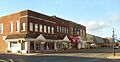
Downtown Tahlequah
-
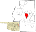
Location within Cherokee County and the state of Oklahoma
-
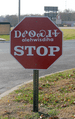
Cherokee stop sign with Cherokee language transliteration and the Cherokee syllabary in Tahlequah, Oklahoma, with "alehwisdiha" (also spelled "halehwisda") meaning "stop"
-
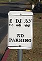
Cherokee traffic sign in Tahlequah, Oklahoma, reading "tla adi yigi", meaning "no parking" from "tla" meaning "no"
-

Tahlequah is home to Northeastern State University.
See also
 In Spanish: Tahlequah (Oklahoma) para niños
