Adair County, Oklahoma facts for kids
Quick facts for kids
Adair County
|
|
|---|---|

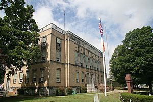
Adair County Courthouse
|
|

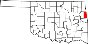
Location within the U.S. state of Oklahoma
|
|
 Oklahoma's location within the U.S. |
|
| Country | |
| State | |
| Founded | July 16, 1907 |
| Named for | The Adair family of the Cherokee tribe. |
| Seat | Stilwell |
| Largest city | Stilwell |
| Area | |
| • Total | 577 sq mi (1,490 km2) |
| • Land | 573 sq mi (1,480 km2) |
| • Water | 3.6 sq mi (9 km2) 0.6%% |
| Population
(2020)
|
|
| • Total | 19,495 |
| • Density | 33.787/sq mi (13.045/km2) |
| Time zone | UTC−6 (Central) |
| • Summer (DST) | UTC−5 (CDT) |
| Congressional district | 2nd |
Adair County is a county in the state of Oklahoma, USA. In 2020, about 19,495 people lived there. The main town and county seat is Stilwell.
Adair County got its name from the Adair family, who were part of the Cherokee tribe. Some say it was named specifically for Watt Adair. He was one of the first Cherokee people to live in the area. Adair County is also part of the Cherokee Nation reservation.
Contents
History of Adair County
Adair County was created in 1906. It was formed from parts of the Cherokee Nation called Goingsnake and Flint districts. For about ten years, there was a disagreement over which town should be the county seat. The choices were Stilwell and Westville.
When the county first started, Westville was chosen as the county seat. This was partly because two big railroads, the Kansas City Southern Railway and the St. Louis – San Francisco Railway, met there. But in 1910, the county seat was moved to Stilwell.
During the Great Depression and World War II, growing strawberries became very important in Adair County. The first Stilwell Strawberry Festival was held in 1948. In 2002, about 40,000 people came to the festival!
In 1910, 10,535 people lived in the county. By 1990, the population had grown to 18,421.
Geography of Adair County
Adair County covers a total area of about 577 square miles (1,494 square kilometers). Most of this area, 573 square miles (1,484 square kilometers), is land. Only a small part, about 3.6 square miles (9.3 square kilometers), is water.
The county is part of the Ozark plateau. This area has tree-covered hills that are part of the Boston Mountains. The northern and central parts of Adair County are drained by the Illinois River. Three other creeks also flow through these areas. Two more creeks are located near Stilwell.
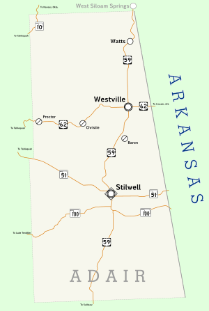
Major Roads
Neighboring Counties
- Delaware County (north)
- Benton County, Arkansas (northeast)
- Washington County, Arkansas (east)
- Crawford County, Arkansas (southeast)
- Sequoyah County (south)
- Cherokee County (west)
Protected Natural Areas
- Ozark Plateau National Wildlife Refuge
People of Adair County (Demographics)
| Historical population | |||
|---|---|---|---|
| Census | Pop. | %± | |
| 1910 | 10,535 | — | |
| 1920 | 13,703 | 30.1% | |
| 1930 | 14,756 | 7.7% | |
| 1940 | 15,755 | 6.8% | |
| 1950 | 14,918 | −5.3% | |
| 1960 | 13,112 | −12.1% | |
| 1970 | 15,141 | 15.5% | |
| 1980 | 18,575 | 22.7% | |
| 1990 | 18,421 | −0.8% | |
| 2000 | 21,038 | 14.2% | |
| 2010 | 22,683 | 7.8% | |
| 2020 | 19,495 | −14.1% | |
| U.S. Decennial Census 1790-1960 1900-1990 1990-2000 2010 |
|||
In 2010, Adair County had 21,038 people. A large part of the population, about 43.3 percent, were Native American. About 43 percent were white. Another 10.5 percent were of more than one race. About 5.3 percent were Hispanic or Latino.
This makes Adair County the only county in Oklahoma where a group other than white people makes up the majority. It also has a higher percentage of Native Americans than any other county in Oklahoma. In 2020, the population was 19,495.
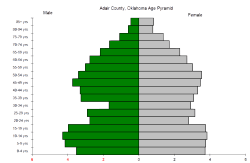
The average age of people in Adair County was 36.2 years. About two-thirds of the people were either under 18 years old (28 percent) or between 25 and 44 years old (24.8 percent).
Economy of Adair County
The county has several important industries. These include food processing and canning factories. There are also many poultry farms, which raise chickens. Cattle ranches, horse breeders, and dog breeders are also found here. Strawberry fields are still an important part of the economy.
Towns and Communities
City
- Stilwell (This is the county seat)
Towns
Other Communities (Census-designated places)
- Baron
- Bell
- Bunch
- Cave Spring
- Chance
- Cherry Tree
- Chewey
- Christie
- Elm Grove
- Elohim City
- Fairfield
- Greasy
- Honey Hill
- Lyons Switch
- Marietta
- Mulberry
- Old Green
- Peavine
- Piney
- Proctor
- Rocky Mountain
- Salem
- Titanic
- Watts Community (This used to be a community)
- Wauhillau
- West Peavine
- Zion
Other Unincorporated Places
Historic Places (NRHP sites)
Several places in Adair County are listed on the National Register of Historic Places. This means they are important historical sites.
- Adair County Courthouse, Stilwell
- Breadtown, near Westville
- Ballard Creek Roadbed, near Westville
- Buffington Hotel, Westville
- Golda's Mill, Stilwell
- Opera Block, Westville
- Rev. Jesse Bushyhead Grave, Westville
See also
 In Spanish: Condado de Adair (Oklahoma) para niños
 | Aaron Henry |
 | T. R. M. Howard |
 | Jesse Jackson |


