
Benton County, Arkansas facts for kids
Quick facts for kids
Benton County
|
|||
|---|---|---|---|
     Clockwise from top: Benton County Courthouse in Bentonville, Beaver Lake, downtown Rogers, Mildred B. Cooper Memorial Chapel in Bella Vista, and downtown Bentonville
|
|||
|
|||

Location within the U.S. state of Arkansas
|
|||
 Arkansas's location within the U.S. |
|||
| Country | |||
| State | |||
| Founded | September 30, 1836 | ||
| Named for | Thomas Hart Benton | ||
| Seat | Bentonville | ||
| Largest city | Rogers | ||
| Area | |||
| • Total | 884 sq mi (2,290 km2) | ||
| • Land | 847 sq mi (2,190 km2) | ||
| • Water | 37 sq mi (100 km2) 4.1%% | ||
| Population
(2020)
|
|||
| • Total | 284,333 | ||
| • Estimate
(2022)
|
302,863 |
||
| • Density | 321.64/sq mi (124.19/km2) | ||
| Time zone | UTC−6 (Central) | ||
| • Summer (DST) | UTC−5 (CDT) | ||
| Congressional district | 3rd | ||


Benton County is a county in the northwest part of Arkansas, a state in the United States. It was created on September 30, 1836, making it Arkansas's 35th county. Benton County has thirteen cities and towns. Bentonville is the county seat, which means it's where the county government is located. Rogers is the biggest city in the county. The county is named after Thomas Hart Benton, a U.S. Senator from Missouri who helped Arkansas become a state.
Benton County is located in the Ozarks mountains, specifically on the Springfield Plateau. A large part of eastern Benton County is next to Beaver Lake, which is a big lake formed by a dam on the White River. The county has several protected natural areas, including Logan Cave National Wildlife Refuge and Pea Ridge National Military Park. Parts of the Ozark National Forest and Hobbs State Park – Conservation Area are also in Benton County.
The county covers about 884 square miles (2,290 square kilometers). In 2020, about 284,333 people lived here, making it the second most populated county in Arkansas. The economy of Benton County is strongly connected to Walmart, which has its main office in Bentonville. Many other businesses that work with Walmart are also in the area. Farming, tourism, and building new homes and businesses are also important for the county's economy. Benton County has the highest average household income in Arkansas.
Contents
History of Benton County
Before settlers from Europe arrived, the area was used by the Osage and Delaware tribes for hunting. The first European settlers came around 1830, mostly from Tennessee. Benton County was officially created from parts of Washington County on September 30, 1836. It was named after Senator Thomas Hart Benton, who helped Arkansas become a state.
After the county was formed, a group of citizens chose Bentonville as the county seat in 1837. The first courthouse was the home of the county judge. Later, a log building and then a brick building were used. The brick courthouse was burned during the Civil War in 1862. After the war, new courthouses were built, and the current Benton County Courthouse was finished in 1928.
On May 26, 2024, Benton County experienced a very strong tornado, which was the largest in Arkansas history. This event brought help from the FEMA for the first time in Arkansas.
Geography and Nature
Benton County is part of the Ozark Mountains, specifically the Springfield Plateau. This area has gently rolling hills, unlike the steeper mountains to the south. It also has special features like springs, sinkholes, and caves. In the past, the land was covered by oak forests and tall grasslands. Today, much of it is used for farming or new neighborhoods.
The county has a total area of about 884 square miles (2,290 square kilometers). About 847 square miles (2,194 square kilometers) is land, and 37 square miles (96 square kilometers) is water. Most of this water is in Beaver Lake.
Benton County is about 112 miles (180 kilometers) east of Tulsa, Oklahoma. It's also about 212 miles (341 kilometers) south of Kansas City, Missouri, and 215 miles (346 kilometers) northwest of Little Rock, Arkansas. The county is surrounded by other counties in Missouri, Oklahoma, and Arkansas. The highest point in Benton County is Whitney Mountain, near Lost Bridge Village.
Waterways and Springs

Benton County has five main watershed areas, which are regions where all the water drains into a specific river or lake. The eastern part of the county drains into the White River, which includes Beaver Lake. Other parts of the county drain into rivers like the Elk River, Illinois River, and Flint Creek.
The county is also known for its natural springs, which were very important to early settlers. Many towns in Benton County are named after these springs, such as Cave Springs, Elm Springs, and Siloam Springs.
Protected Natural Areas
Benton County has several protected areas, some managed by the federal government and others by the state.
- Logan Cave National Wildlife Refuge protects endangered animals like the gray bat and Ozark cavefish.
- Pea Ridge National Military Park protects the site of the Battle of Pea Ridge, an important battle during the Civil War.
- Other areas like Beaver Lake Wildlife Management Area and Devil's Eyebrow Natural Area protect the Ozark Mountain landscape around Beaver Lake.
- Chesney Prairie Natural Area and Searles Prairie Natural Area protect the flat grasslands of the Springfield Plateau.
- Parts of the Ozark National Forest are also in the county.
People of Benton County
| Historical population | |||
|---|---|---|---|
| Census | Pop. | %± | |
| 1840 | 2,228 | — | |
| 1850 | 3,710 | 66.5% | |
| 1860 | 9,306 | 150.8% | |
| 1870 | 13,831 | 48.6% | |
| 1880 | 20,328 | 47.0% | |
| 1890 | 27,716 | 36.3% | |
| 1900 | 31,611 | 14.1% | |
| 1910 | 33,389 | 5.6% | |
| 1920 | 36,253 | 8.6% | |
| 1930 | 35,253 | −2.8% | |
| 1940 | 36,148 | 2.5% | |
| 1950 | 38,076 | 5.3% | |
| 1960 | 36,272 | −4.7% | |
| 1970 | 50,476 | 39.2% | |
| 1980 | 78,115 | 54.8% | |
| 1990 | 97,499 | 24.8% | |
| 2000 | 153,406 | 57.3% | |
| 2010 | 221,339 | 44.3% | |
| 2020 | 284,333 | 28.5% | |
| 2023 (est.) | 311,013 | 40.5% | |
| U.S. Decennial Census 1790–1960 1900–1990 1990–2000 2010–2020 2020 |
|||

As of the 2020 census, there were 284,333 people living in Benton County. The county has grown a lot over the years. In 2020, about 71.34% of the people were White (not Hispanic), 1.59% Black or African American, 1.34% Native American, and 4.78% Asian. About 17.61% of the population was Hispanic or Latino.
Local Culture
For many years, Benton County was a "dry county," meaning that alcohol sales were not allowed. This rule stayed in place even after the end of Prohibition in 1933. However, in 2012, voters in Benton County decided to make the county "wet," which means that stores and restaurants can now sell alcohol.
Economy and Businesses
Benton County is home to several large and important companies:
- Walmart: This huge retail company was started in Rogers, and its main office is in Bentonville.
- Daisy Outdoor Products: This company, famous for its air rifles, has its headquarters in Rogers.
- JB Hunt Transport Services: A major transportation company, its main office is in Lowell.
- Tyson Foods: While based in Springdale, this large food company has a distribution center in Rogers.
- Simmons Foods: This company, which provides poultry, pet, and animal nutrition products, is based in Siloam Springs.
- America's Car-Mart: One of the biggest car retailers in the U.S., it is based in Rogers.
Getting Around Benton County
Main Roads
 Interstate 49
 U.S. Highway 62
 U.S. Highway 71
 U.S. Highway 412
 Highway 12
 Highway 16
 Highway 43
 Highway 59
 Highway 72
 Highway 94
 Highway 102
 Highway 112
 Highway 127
 Highway 244
 Highway 264
 Highway 265
 Highway 279
 Highway 303
 Highway 340
 Highway 549
 Highway 612
The historic Trail of Tears passes through the county on U.S. Highways 62 and 71.
Airports
- Northwest Arkansas National Airport (XNA) is located near Highfill.
- Rogers Municipal Airport (ROG) serves the county and nearby towns.
Railways
The Arkansas and Missouri Railroad runs through the county, following U.S. Highways 62 and 71. The St. Louis–San Francisco Railway, also known as the "Frisco," was completed across Benton County in 1881.
Cities and Towns
Cities
- Bella Vista
- Bentonville (county seat)
- Cave Springs
- Centerton
- Decatur
- Elm Springs (mostly in Washington County)
- Gentry
- Gravette
- Little Flock
- Lowell
- Pea Ridge
- Rogers
- Siloam Springs
- Springdale (mostly in Washington County)
- Sulphur Springs
Towns
Census-Designated Places (CDPs)
These are areas that are like towns but are not officially incorporated as cities or towns.
Townships

Most counties in Arkansas have names for their townships, which are small divisions of the county. However, Benton County uses numbers instead of names for its townships.
Education
Here are the main school districts in Benton County:
- Bentonville Public Schools
- Decatur School District
- Gentry Public Schools
- Gravette School District
- Pea Ridge School District
- Rogers Public Schools
- Siloam Springs Schools
- Springdale School District
Images for kids
-
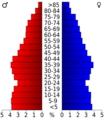
Age pyramid Benton County
See also
 In Spanish: Condado de Benton (Arkansas) para niños
