
Pea Ridge, Arkansas facts for kids
Quick facts for kids
Pea Ridge, Arkansas
|
|
|---|---|

Pea Ridge Commercial Historic District
|
|

Location of Pea Ridge in Benton County, Arkansas.
|
|
| Country | |
| State | |
| County | Benton |
| Area | |
| • Total | 7.58 sq mi (19.64 km2) |
| • Land | 7.58 sq mi (19.64 km2) |
| • Water | 0.00 sq mi (0.00 km2) |
| Elevation | 1,312 ft (400 m) |
| Population
(2020)
|
|
| • Total | 6,559 |
| • Density | 864.96/sq mi (333.94/km2) |
| Time zone | UTC-6 (Central (CST)) |
| • Summer (DST) | UTC-5 (CDT) |
| ZIP code |
72751
|
| Area code(s) | 479 |
| FIPS code | 05-54200 |
| GNIS feature ID | 2404492 |
Pea Ridge is a city located in Benton County, Arkansas, in the United States. Its name comes from two things. First, the town was built on a ridge in the Ozark Mountains. Second, Native American tribes grew "hog peanuts" or "turkey peas" there a long time ago. These plants later helped early pioneer settlers find food.
Pea Ridge is most famous for a big battle during the American Civil War. This battle, called the Battle of Pea Ridge (or Battle of Elkhorn Tavern), happened about 5 miles (8 km) east of the town. Today, you can visit the battle site at the Pea Ridge National Military Park.
The main business area of Pea Ridge is listed on the National Register of Historic Places. It has many old buildings from the late 1800s and early 1900s. In 2020, about 6,559 people lived in Pea Ridge. It is part of the larger Northwest Arkansas area. The local newspaper is called the Times of Northeast Benton County.
Contents
Exploring Pea Ridge's Location
Pea Ridge is easy to get to by road. Arkansas Highway 94 is the main road that goes through the city. It leads south about 8 miles (13 km) to Rogers and northwest about 6 miles (10 km) to the Missouri border.
Another road, Arkansas Highway 72, goes east about 5 miles (8 km) to U.S. Route 62 near the Pea Ridge National Military Park. It also goes southwest about 9 miles (14 km) to Bentonville.
The United States Census Bureau says that Pea Ridge covers about 7.58 square miles (19.64 square kilometers) of land. There is no water area within the city limits.
Pea Ridge's Growing Population
Pea Ridge has grown a lot over the years! Here's how its population has changed:
| Historical population | |||
|---|---|---|---|
| Census | Pop. | %± | |
| 1940 | 72 | — | |
| 1950 | 268 | 272.2% | |
| 1960 | 380 | 41.8% | |
| 1970 | 1,088 | 186.3% | |
| 1980 | 1,488 | 36.8% | |
| 1990 | 1,620 | 8.9% | |
| 2000 | 2,346 | 44.8% | |
| 2010 | 4,794 | 104.3% | |
| 2020 | 6,559 | 36.8% | |
| U.S. Decennial Census | |||
People in Pea Ridge (2020 Census)
In 2020, the 2020 United States census counted 6,559 people living in Pea Ridge. There were 2,021 households and 1,455 families.
| Race | Number | Percentage |
|---|---|---|
| White (non-Hispanic) | 5,444 | 83.0% |
| Black or African American (non-Hispanic) | 55 | 0.84% |
| Native American | 59 | 0.9% |
| Asian | 39 | 0.59% |
| Pacific Islander | 4 | 0.06% |
| Other/Mixed | 437 | 6.66% |
| Hispanic or Latino | 521 | 7.94% |
People in Pea Ridge (2010 Census)
According to the 2010 Census, Pea Ridge had 4,794 people. Most people were white (90.7%). About 5.8% of the population was Hispanic or Latino.
There were 1,300 homes in the city. In 37.3% of these homes, there were children under 18 years old. Many homes (63.3%) had married couples living together.
The population was spread out by age. About 26.9% of people were under 18. About 15.1% were 65 years old or older. The average age in Pea Ridge was 36 years.
Education in Pea Ridge
Most students in Pea Ridge go to schools in the Pea Ridge School District. This district includes Pea Ridge High School. A small part of the city is zoned for Rogers Public Schools.
Historic Images of Pea Ridge
-
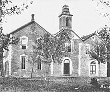
The 1880 Pea Ridge Masonic College building as it appeared in 1920, about ten years before it was razed
-
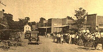
Downtown Pea Ridge looking east on Pickens Road in 1914. The white structure at the end of the street was a hotel operated by the Martin family, which burned down around 1920.
-
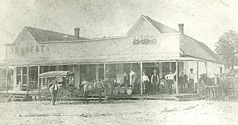
The original J.J. Putnam's general merchandise store, which later burned down and was replaced with a cement block building, which still stands on the southeast corner of Pickens Road and Curtis Avenue. This photo antedates 1914.
-
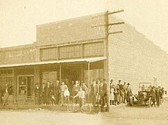
The cement block building that replaced J.J. Putnam's first general merchandise store, which burned, on the southeast corner of Pickens Road and Curtis Avenue in 1914.


See also
 In Spanish: Pea Ridge (Arkansas) para niños
