Highfill, Arkansas facts for kids
Quick facts for kids
Highfill, Arkansas
|
|
|---|---|

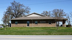
City Hall
|
|

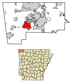
Location of Highfill in Benton County, Arkansas.
|
|
| Country | United States |
| State | Arkansas |
| County | Benton |
| Area | |
| • Total | 18.13 sq mi (46.94 km2) |
| • Land | 18.02 sq mi (46.68 km2) |
| • Water | 0.10 sq mi (0.27 km2) |
| Elevation | 1,355 ft (413 m) |
| Population
(2020)
|
|
| • Total | 1,587 |
| • Density | 88.06/sq mi (34.00/km2) |
| Time zone | UTC-6 (Central (CST)) |
| • Summer (DST) | UTC-5 (CDT) |
| ZIP codes |
72712, 72713, 72734, 72761
|
| Area code(s) | 479 |
| FIPS code | 05-32200 |
| GNIS feature ID | 0057923 |
Highfill is a small town located in Benton County, Arkansas, United States. In 2020, about 1,587 people lived there. Highfill is special because it's home to the Northwest Arkansas National Airport. This airport helps people travel all over the Northwest Arkansas area. In 2023, the airport decided to try and separate from the town. This was because of disagreements about taxes and city services.
Contents
Where is Highfill Located?
Highfill is in the western part of Benton County. It sits at coordinates 36°16′14″N 94°19′30″W / 36.27056°N 94.32500°W. A main road, Arkansas Highway 12, goes through the town. This highway connects Highfill to nearby cities like Bentonville, Rogers, and Gentry. The Northwest Arkansas National Airport is located on the eastern side of Highfill.
The town covers a total area of about 47.3 square kilometers (18.3 square miles). Most of this area is land, with a small part being water.
Highfill's Population Over Time
| Historical population | |||
|---|---|---|---|
| Census | Pop. | %± | |
| 1960 | 92 | — | |
| 1970 | 80 | −13.0% | |
| 1980 | 92 | 15.0% | |
| 1990 | 84 | −8.7% | |
| 2000 | 379 | 351.2% | |
| 2010 | 583 | 53.8% | |
| 2020 | 1,587 | 172.2% | |
| U.S. Decennial Census | |||
In 2010, there were 561 people living in Highfill. They lived in 191 households, and 153 of these were families. The town's population density was about 12.9 people per square kilometer.
Most people in Highfill were White (92.08%). There were also people who identified as Native American, Asian, or from other backgrounds. A small number of people were Hispanic or Latino.
About 32.6% of households had children under 18 living with them. Many households (61.1%) were married couples. The average household had 2.63 people. The average family had 2.90 people.
The population was spread out by age. About 26.4% were under 18 years old. The median age in Highfill was 34 years. This means half the people were younger than 34 and half were older.
Schools in Highfill
Students in Highfill can attend public schools in different districts. This depends on where they live in the town.
- Some students go to the Gentry School District. They can graduate from Gentry High School.
- Other students are part of the Bentonville School District. Their schools include Vaughn Elementary, Creekside Middle, Grimsley Junior High, and Bentonville West High School.
- A small part of Highfill is in the Decatur School District. Students here attend Decatur High School.
Disagreement with the Airport
In September 2023, the board of the Northwest Arkansas National Airport (XNA) decided to start the process of separating from Highfill. All board members present voted for this change.
One big reason for the disagreement was taxes. All things bought or sold at the airport had a 2% sales tax from Highfill. Airport lawyers argued that the airport did not get city services. This included things like police, fire protection, or road repairs.
A new law in Arkansas from 2023 states that if the airport leaves the city, it might have to help pay off some of the city's debts.
See also
 In Spanish: Highfill (Arkansas) para niños
 | Emma Amos |
 | Edward Mitchell Bannister |
 | Larry D. Alexander |
 | Ernie Barnes |


