
Lowell, Arkansas facts for kids
Quick facts for kids
Lowell, Arkansas
|
||
|---|---|---|

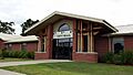
City Hall
|
||
|
||

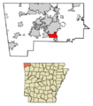
Location of Lowell in Benton County, Arkansas.
|
||
| Country | United States | |
| State | Arkansas | |
| County | Benton | |
| Incorporated | 1881 | |
| Area | ||
| • Total | 9.68 sq mi (25.06 km2) | |
| • Land | 9.61 sq mi (24.90 km2) | |
| • Water | 0.06 sq mi (0.16 km2) | |
| Elevation | 1,322 ft (403 m) | |
| Population
(2020)
|
||
| • Total | 9,839 | |
| • Density | 1,023.40/sq mi (395.15/km2) | |
| Time zone | UTC-6 (Central) | |
| • Summer (DST) | UTC-5 (Central) | |
| ZIP code |
72745
|
|
| Area code(s) | 479 | |
| FIPS code | 05-41720 | |
| GNIS feature ID | 2404965 | |

Lowell is a city located in Benton County, Arkansas, in the United States. It is nestled within the beautiful Ozarks. The first small community here started in the 1840s along Old Wire Road.
Even though the original settlement was destroyed during the American Civil War, it was rebuilt by J. R. McClure. The city really began to grow in the 1880s when the St. Louis–San Francisco Railway built tracks through the area.
Today, Lowell is a fast-growing "bedroom community." This means many people who live in Lowell travel to nearby cities for work. Lowell is part of the quickly expanding Northwest Arkansas region. It is also home to the main office of J.B. Hunt, a large trucking company. In 2020, Lowell had a population of 9,839 people, which was a big increase from 2010.
Contents
History of Lowell, Arkansas
Lowell was officially planned and laid out as a city in 1881. A post office has been serving the community of Lowell since that same year.
Geography of Lowell
Lowell is located in the southern part of Benton County. It covers about 9.68 square miles (25.06 square kilometers). Most of this area is land, with a small amount of water.
Lowell shares borders with several other cities:
- Springdale is to the south.
- Cave Springs is to the west.
- Rogers is to the north.
About 4 miles (6.4 km) to the east of Lowell is Beaver Lake. This is a very large reservoir, which is like a big artificial lake, that is part of the White River system.
What is the Northwest Arkansas Metropolitan Area?
The Northwest Arkansas region includes three counties in Arkansas: Benton, Madison, and Washington. This area has grown a lot! In 2000, about 347,045 people lived there. By 2010, the population had increased to 463,204, which is a jump of over 33%.
Unlike some big cities where one main city has many smaller suburbs, Northwest Arkansas has four main cities lined up along Interstate 49. Lowell is also located along this important road, right between Springdale and Rogers.
Population Changes in Lowell
| Historical population | |||
|---|---|---|---|
| Census | Pop. | %± | |
| 1910 | 193 | — | |
| 1920 | 227 | 17.6% | |
| 1930 | 262 | 15.4% | |
| 1940 | 271 | 3.4% | |
| 1950 | 341 | 25.8% | |
| 1960 | 277 | −18.8% | |
| 1970 | 653 | 135.7% | |
| 1980 | 1,078 | 65.1% | |
| 1990 | 1,224 | 13.5% | |
| 2000 | 5,013 | 309.6% | |
| 2010 | 7,327 | 46.2% | |
| 2020 | 9,839 | 34.3% | |
| U.S. Decennial Census | |||
Lowell's Population in 2020
In 2020, the 2020 United States census counted 9,839 people living in Lowell. There were 3,277 households and 2,302 families.
| Race | Number | Percentage |
|---|---|---|
| White (non-Hispanic) | 5,752 | 68.88% |
| Black or African American (non-Hispanic) | 144 | 0.29% |
| Native American | 75 | 0.76% |
| Asian | 230 | 2.34% |
| Pacific Islander | 185 | 1.88% |
| Other/Mixed | 589 | 5.99% |
| Hispanic or Latino | 2,864 | 22.11% |
Lowell's Population in 2010
According to the 2010 census, Lowell had a population of 7,327 people. The population was made up of different groups:
- 68.7% non-Hispanic white
- 0.9% black or African American
- 1.4% Native American
- 2.7% Asian
- 0.4% Pacific Islander
- 2.6% from two or more races
- 24.7% Hispanic or Latino
Education in Lowell
Students in Lowell attend public schools managed by the Rogers School District. Lowell has two elementary schools:
- Lowell Elementary School
- Elza R. Tucker Elementary School
Janie Darr Elementary School is also very close to the city.
After elementary school, students go to middle school. Lowell Elementary students go to Kirksey Middle School. Students from Tucker and Darr elementaries go to Elmwood Middle School. Both Kirksey and Elmwood middle schools feed into Rogers High School.
Lowell Elementary School was recognized in 2015 as an Arkansas Reward School. This means it was one of the top 5% of schools for high student performance and academic growth.
Grace Lutheran School is a private Christian school in Lowell. It offers pre-school and grade school education.
Transportation in Lowell

U.S. Route 71B runs through the center of Lowell. It is known as Bloomington Street. This road goes north about 5 miles (8 km) to Rogers and south 5 miles (8 km) to Springdale.
Interstate 49 and U.S. Route 71 are major highways that pass west of downtown Lowell. You can get to Lowell from I-49 at Exit 78, which is Arkansas Highway 264. I-49 goes north to Bentonville and south to Fayetteville and Fort Smith. Highway 264 is an important east-west road in Lowell. It connects I-49 and US 71B.
Notable People from Lowell
- Duncan Baird: A state representative for District 96 and a securities trader in Lowell.
- Ryan Foster: A professional racing driver.
See also
 In Spanish: Lowell (Arkansas) para niños
Images for kids
-
City Hall
-
City Seal
-
Location of Lowell in Benton County, Arkansas.
-
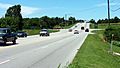
Highway 264 near the I-49 interchange
