Westville, Oklahoma facts for kids
Quick facts for kids
Westville
|
|
|---|---|
|
Town
|
|
| Town of Westville, Oklahoma | |

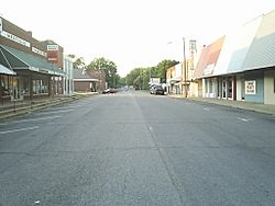
Downtown Westville north up Williams Street. The Buffington Hotel is on the left.
|
|
| Motto(s):
Golden Opportunities
|
|

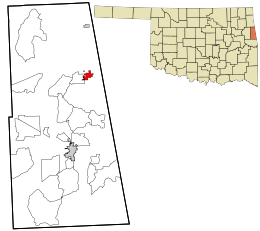
Location within Adair County, Cherokee Nation Reservation and the state of Oklahoma
|
|
| Country | |
| State | |
| County | Adair |
| Incorporated | 1907 |
| Town Founded | November 18, 1895 |
| Named for | Jim West |
| Government | |
| • Type | Weak mayor |
| • Body | Town Council of Westville |
| Area | |
| • Total | 1.8 sq mi (4.66 km2) |
| • Land | 1.8 sq mi (4.66 km2) |
| • Water | 0.00 sq mi (0.00 km2) |
| Elevation | 1,152 ft (351 m) |
| Population
(2023)
|
|
| • Total | 1,357 |
| • Density | 1,118.20/sq mi (431.74/km2) |
| Time zone | UTC-6 (Central) |
| • Summer (DST) | UTC-5 (Central) |
| ZIP code |
74965
|
| Area code(s) | 539/918 |
| FIPS code | 40-80450 |
| GNIS feature ID | 2413475 |
Westville is a town in Adair County, Oklahoma. It is located in the foothills of the Ozark Mountains. Westville is found where U.S. Highways 59 and 62 meet. It is about 13 miles north of Stilwell, which is the main town in Adair County.
Contents
History of Westville
Early Days and Founding
Before Oklahoma became a state, Westville was a community in the Cherokee Nation. This area was known as the Goingsnake District. The town officially started in 1895. This happened when the Kansas City, Pittsburg and Gulf Railroad was building a train line. This line went all the way from Kansas City to the Gulf Coast.
The Westville post office opened on November 18, 1895. The town was named after Jim West. He lived nearby, and his son, Jim West Jr., was a lawyer for the railroad company.
Railroads and Growth
The first plan for Westville covered 175 acres. The town quickly grew with new areas added. In 1902, another train line started running through Westville. This was the Ozark and Cherokee Central Railway. It connected Fayetteville, Arkansas, to Okmulgee, Oklahoma.
Having two major train lines made Westville an important place. The second line was later owned by the St. Louis – San Francisco Railway. However, it stopped service to Westville in the late 1940s.
Westville as County Seat
When Adair County was created in 1907, Westville was chosen as the county seat. A county seat is the main town where the county government is located. Westville was chosen because of its location at the crossing of two big railroads. But in 1910, the county seat was moved to Stilwell.
Geography of Westville
Location and Area
Westville is about 13 miles (21 km) north of Stilwell. It is also about 15 miles (24 km) south of Siloam Springs, Arkansas.
The United States Census Bureau says that Westville covers a total area of 1.2 square miles (3.1 square kilometers). All of this area is land.
Major Roads
Westville is located at the intersection of two important U.S. Routes. These are U.S. Route 59 and U.S. Route 62.
Population and People
How Many People Live Here?
| Historical population | |||
|---|---|---|---|
| Census | Pop. | %± | |
| 1900 | 296 | — | |
| 1910 | 802 | 170.9% | |
| 1920 | 956 | 19.2% | |
| 1930 | 691 | −27.7% | |
| 1940 | 716 | 3.6% | |
| 1950 | 781 | 9.1% | |
| 1960 | 727 | −6.9% | |
| 1970 | 934 | 28.5% | |
| 1980 | 1,049 | 12.3% | |
| 1990 | 1,374 | 31.0% | |
| 2000 | 1,596 | 16.2% | |
| 2010 | 1,632 | 2.3% | |
| 2020 | 1,639 | 0.4% | |
| U.S. Decennial Census | |||
According to the census from the year 2000, there were 1,596 people living in Westville. These people lived in 599 households. About 401 of these were families.
Diversity in Westville
The people in Westville come from different backgrounds. In 2000, about 62% of the people were White. About 28% were Native American. Other groups made up smaller parts of the population. About 6% of the people were Hispanic or Latino.
Age Groups
The population of Westville includes people of all ages. In 2000, about 30% of the people were under 18 years old. About 16% were 65 years old or older. The average age in the town was 34 years.
Historic Places in Westville
National Register of Historic Places Sites
Several places in Westville are listed on the National Register of Historic Places. This means they are important historical sites.
- The Buffington Hotel: This old hotel is located on Main Street.
- The Rev. Jesse Bushyhead Grave: This grave has a tall marble monument. It honors a Cherokee religious and political leader. It is in the Baptist Mission Cemetery.
- The Opera Block: This building was also on Main Street, but it has been taken down.
- The Ballard Creek Roadbed: This site is important to the Cherokee Trail of Tears. The Trail of Tears was a difficult journey for the Cherokee people.
- Breadtown: This is another site related to the Cherokee Trail of Tears.
Notable People from Westville
Westville is home to some well-known people:
- Markwayne Mullin: He is a United States Senator from Oklahoma. He used to be a U.S. House Representative.
- Jim Ross: He is a famous sports commentator for World Wrestling Entertainment.
See also
 In Spanish: Westville (Oklahoma) para niños
 | Delilah Pierce |
 | Gordon Parks |
 | Augusta Savage |
 | Charles Ethan Porter |

