Cogar, Oklahoma facts for kids
Quick facts for kids
Cogar, Oklahoma
|
|
|---|---|
 |
|
| Country | United States |
| State | Oklahoma |
| County | Caddo |
| Elevation | 1,470 ft (448 m) |
| Time zone | UTC-6 (Central (CST)) |
| • Summer (DST) | UTC-5 (CDT) |
| GNIS feature ID | 1100310 |
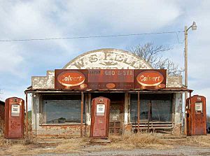
Cogar is a small, quiet community in Caddo County, Oklahoma, in the United States. It's a rural area, meaning it's mostly countryside with farms and open spaces, not a big city.
Where is Cogar Located?
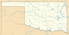
Cogar is in the northeastern part of Caddo County. You can find it about 10 miles west of a town called Minco, Oklahoma. It's right on Oklahoma State Highway 37. If you travel about 5 miles east from Salyer Lake, you'll find Cogar on Oklahoma State Highway 152. It sits at an elevation of 448 meters (about 1,470 feet) above sea level.
A Look at Cogar's Past
Cogar once had its own post office. This post office opened its doors on March 25, 1902. For over 50 years, it served the community. However, it eventually closed down on September 30, 1954. Today, Cogar remains a small, unincorporated community. This means it doesn't have its own local government like a city or town.
 | Shirley Ann Jackson |
 | Garett Morgan |
 | J. Ernest Wilkins Jr. |
 | Elijah McCoy |


