
Antelope Hills, Oklahoma facts for kids
Quick facts for kids Antelope Hills |
|
|---|---|

The Antelope Hills
|
|
| Highest point | |
| Elevation | 2,585 ft (788 m) |
| Geography | |
| Country | United States |
| State/Province | Oklahoma |
| District | Roger Mills County, Oklahoma |
| Range coordinates | 35°54′15″N 99°53′04″W / 35.9042117°N 99.8845604°W |
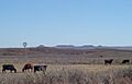
The Antelope Hills are a group of small hills located in Roger Mills County, Oklahoma. They are found in the curve of the Canadian River, close to the border between western Oklahoma and the Texas Panhandle. These hills were a very important landmark for the Plains Indians and early travelers crossing the western plains of Oklahoma.
Long ago, this area was part of the Cheyenne-Arapaho reservation. Later, in 1892, a big event called the Land Run of 1892 opened the land for new settlers. Today, the Antelope Hills are recognized as a special place. They are listed on the National Register of Historic Places because of their historical importance.
Contents
A Look at the Antelope Hills' Past
Early History and European Exploration
Evidence suggests that people lived and hunted in the Antelope Hills area thousands of years ago. The first European to mention these hills was a Spanish explorer named Francisco Vásquez de Coronado. He wrote about them in 1541 during his travels.
Later, in 1682, a French explorer named René Robert Cavelier, Sieur de La Salle claimed this land for Spain. However, Spain gave it to France in 1800. Just three years later, in 1803, the United States bought this huge area. This famous purchase was known as the Louisiana Purchase.
From Indian Territory to Oklahoma Statehood
The Antelope Hills region was part of what was called Indian Territory. This changed in 1890 when Oklahoma Territory was created. Before that, in 1867, the land had become a reservation for the Cheyenne-Arapaho tribes.
The Land Run of 1892 was a major event that opened this area to non-Native American settlers. After the land run, the area became part of "County F." When Oklahoma officially became a state in 1907, the Antelope Hills became part of Roger Mills County, Oklahoma.
The Comanche and Early Conflicts
Before the American Civil War, the Antelope Hills were part of a large territory called Comancheria. The Comanche tribe considered this land their hunting and grazing grounds. They strongly resisted new settlements by non-Native Americans.
This led to many conflicts. The U.S. military struggled to stop Comanche raids into Texas and Mexico. Finally, in 1858, the Texas Rangers and some Native American allies started a campaign. This campaign ended with the Battle of Little Robe Creek on May 12, 1858.
The California Road and Marcy's Description
After gold was found in California in 1848, many people wanted to travel west. This created a need for a safe wagon road. Captain Randolph B. Marcy was chosen to map a route from Fort Smith to California. This route became known as the California Road.
Marcy described the Antelope Hills in his writings. He said they were about 150 feet high and made of porous sandstone. He thought they looked like they had been pushed up from the earth by volcanic activity. He also noted they were near the 100th degree of longitude. People sometimes called them the "Boundary mounds" because they were close to what Texas once claimed as its eastern border.
National Recognition
The Antelope Hills area was officially added to the National Register of Historic Places on December 14, 1978. This listing recognizes its important historical value.
Modern Day Antelope Hills
Today, the Antelope Hills area is not very crowded. The main ways people make a living here are through farming and producing oil. This is because the area sits on top of two important natural resources: the Ogallala Aquifer, which provides water, and the Anadarko Basin, which holds oil and natural gas.
What the Antelope Hills Look Like
The land in the Antelope Hills was formed by ancient streams. These streams carried sand, clay, and caliche from the Rocky Mountains. Over time, these materials created the sandy, loam soils we see today.
The natural plants here are mostly prairie grasses. You can also find some broadleaf trees. Wooded areas often have cottonwood, willow, mesquite, and eastern red cedar trees.
The wildlife in the area includes animals like mule deer, white-tailed deer, pronghorn antelope, and rabbit. Bird species you might spot are bobwhite quail, Rio Grande turkey, and ring-necked pheasant.
Images for kids
-
The Antelope Hills
