Anadarko Basin facts for kids
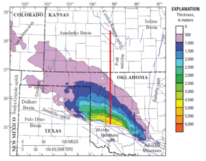
The Anadarko Basin is a huge, bowl-shaped area underground. It's mostly in western Oklahoma and the Texas Panhandle, but also reaches into parts of southwestern Kansas and southeastern Colorado. This basin covers about 50,000 square miles (130,000 km²)! It's super important because it holds a lot of natural resources, especially natural gas. By the end of the 1900s, the Anadarko Basin was producing the most natural gas in the United States. Some famous oil and gas areas here include the Hugoton-Panhandle Gas Field and the Elk City Field. It's also the only place in the U.S. that commercially produces iodine and a big source of helium.
Contents
Understanding the Anadarko Basin's Geology
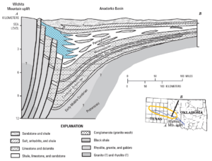
The Anadarko Basin is surrounded by areas where the ground has pushed up, like natural walls. To the south, it's next to the Wichita-Amarillo uplift. To the east, it's near the Nemaha uplift. The Central Kansas uplift is to the north, and the Las Animas arch is to the west.
Inside the basin, there are thick layers of sedimentary rock. These rocks formed from sand, mud, and other materials that settled over millions of years. These layers range in age from the Cambrian period to the Permian period. The rock layers are thickest, over 40,000 feet (12,000 meters), at the southern edge, right next to the Wichita-Amarillo uplift. The basin has a very thick section of rocks from the Pennsylvanian period, which can be up to 15,000 feet (4,600 meters) thick. On the northern and western sides, the rock layers are much thinner, only about 2,000 feet (600 meters) thick.
Important Natural Resources in the Basin
The Anadarko Basin is a treasure chest of natural resources found deep underground.
Natural Gas
This basin holds one of the biggest natural gas reserves in North America. It has produced more than 100 trillion cubic feet (2.8 trillion cubic meters) of gas over time. In 2010, experts estimated that the Anadarko Basin still held 27.5 trillion cubic feet of natural gas and 410 million barrels of natural gas liquids (NGL). It's also the 5th largest natural gas area in the United States.
A famous well called the Lone Star Bertha Rogers well, located in Beckham County, Oklahoma, was once the deepest producing well in the world. It was drilled to an amazing depth of 31,441 feet (9,583 meters) in 1974!
Crude Oil
Besides natural gas, the Anadarko Basin also contains a lot of oil. In 2010, it was estimated to hold 495 million barrels of oil.
Brine and Iodine
The salty water, called brine, found in the Pennsylvanian Morrow Formation within the Anadarko Basin is special. It contains about 300 parts per million of iodine. This makes it the only place in the United States that commercially produces iodine! Iodine is used in many things, like medicines and disinfectants.
Three companies extract iodine from this brine. The brine is a byproduct of natural gas production and comes from wells 5,000 to 13,000 feet (1,500 to 4,000 meters) deep. In 2005, about 1,570 tonnes of iodine were produced. For example, the Woodward Iodine company plant near Woodward, Oklahoma uses a 6,600-foot (2,000-meter) deep well. Another plant, IOCHEM, near Vici, Oklahoma, gets brine from a 9,800-foot (3,000-meter) deep well.
Helium
Some of the natural gas in the Anadarko Basin has a surprisingly high amount of helium (more than 0.3%). Helium is a very light gas used in balloons, for cooling things, and in scientific research. It is recovered from the natural gas as a useful byproduct.
 | Aurelia Browder |
 | Nannie Helen Burroughs |
 | Michelle Alexander |


