Beckham County, Oklahoma facts for kids
Quick facts for kids
Beckham County
|
|
|---|---|

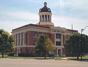
Beckham County Courthouse,
Sayre, Oklahoma 2015 |
|

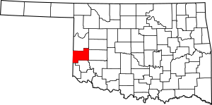
Location within the U.S. state of Oklahoma
|
|
 Oklahoma's location within the U.S. |
|
| Country | |
| State | |
| Founded | November 16, 1907 |
| Named for | J. C. W. Beckham |
| Seat | Sayre |
| Largest city | Elk City |
| Area | |
| • Total | 904 sq mi (2,340 km2) |
| • Land | 902 sq mi (2,340 km2) |
| • Water | 2.1 sq mi (5 km2) 0.2%% |
| Population
(2020)
|
|
| • Total | 22,410 |
| • Density | 24.790/sq mi (9.571/km2) |
| Time zone | UTC−6 (Central) |
| • Summer (DST) | UTC−5 (CDT) |
| Congressional district | 3rd |
Beckham County is a county in the western part of Oklahoma. It sits right on the border with Texas. In 2020, about 22,410 people lived here. The main town, or county seat, is Sayre.
Beckham County was created in 1907 when Oklahoma became a state. It was named after J. C. W. Beckham. He was a governor of Kentucky and later became a U.S. Senator. The county is also part of the Elk City area, which is a smaller city region.
Contents
History of Beckham County
Early Land Changes
Long ago, in 1855, the U.S. government rented out the western part of land that belonged to the Choctaw and Chickasaw Nation tribes. This area was called the "Leased District."
After the American Civil War, these tribes had to give the land back to the U.S. government. This was because they had supported the Confederacy during the war. They also had to free their slaves and make them citizens of their tribes.
In 1869, the U.S. President set aside the former Leased District. It became the Cheyenne and Arapaho Indian Reservation. This was for the Cheyenne and Arapaho tribes. In the 1880s, cattle ranchers from Texas rented land from these tribes to graze their cattle.
New Settlements and County Formation
In 1891, a law called the Dawes Act changed how tribal lands were owned. It divided up shared tribal lands into smaller plots for individual families. Any land left over was called "surplus." In 1892, the government opened this "surplus" land for new settlers. Many European-American families moved in.
This area was first called County F in the new Oklahoma Territory. Later, it was renamed Roger Mills County.
In 1896, a part of Greer County, Texas was given to Oklahoma Territory. This happened after a court case about the border between Texas and Oklahoma. This area then became Greer County, Oklahoma.
When Oklahoma became a state in 1907, parts of Roger Mills County and Greer County were combined. This created Beckham County. Sayre was chosen as the temporary county seat. In 1908, people voted to make Sayre the permanent county seat.
Border Adjustments
In 1910, a small piece of southern Beckham County was given back to Greer County.
Later, in the 1920s, a survey found that the true border between Texas and Oklahoma was actually a bit further east than thought. In 1930, the U.S. Supreme Court decided that a strip of land had to be returned to Texas. This made Beckham County slightly smaller.
Geography
Beckham County covers about 904 square miles. Most of this is land, about 902 square miles. Only a small part, about 2.1 square miles, is water.
The county has several rivers and creeks. The North Fork of the Red River flows through it. Other important creeks are Timber, Sweetwater, and Buffalo creeks. The northwestern part of the county is flat and high, part of the High Plains. The rest of the county has rolling hills made of gypsum rock. This area is called the Gypsum Hills.
Major Roads
Many important roads cross Beckham County:
 Interstate 40
 I-40 Bus. / US-66
 U.S. Highway 283
 State Highway 6
 State Highway 30
 State Highway 34
 State Highway 55
 State Highway 66
 State Highway 152
Neighboring Counties
Beckham County shares borders with several other counties:
- Roger Mills County (north)
- Custer County (northeast)
- Washita County (east)
- Kiowa County (southeast)
- Greer County (south)
- Harmon County (southwest)
- Collingsworth County, Texas (west)
- Wheeler County, Texas (northwest)
Population Facts
| Historical population | |||
|---|---|---|---|
| Census | Pop. | %± | |
| 1910 | 19,699 | — | |
| 1920 | 18,989 | −3.6% | |
| 1930 | 28,991 | 52.7% | |
| 1940 | 22,169 | −23.5% | |
| 1950 | 21,627 | −2.4% | |
| 1960 | 17,782 | −17.8% | |
| 1970 | 15,754 | −11.4% | |
| 1980 | 19,243 | 22.1% | |
| 1990 | 18,812 | −2.2% | |
| 2000 | 19,799 | 5.2% | |
| 2010 | 22,119 | 11.7% | |
| 2020 | 22,410 | 1.3% | |
| U.S. Decennial Census 1790-1960 1900-1990 1990-2000 2010 |
|||
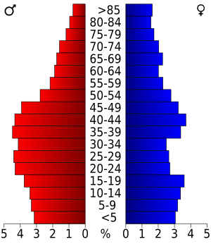
In 2010, there were 22,119 people living in Beckham County. By 2020, the population grew slightly to 22,410.
Most people in the county are white (85%). There are also Black or African American people (4%), Native Americans (2.8%), and Asians (0.8%). About 12% of the population is Hispanic or Latino.
In 2010, about 34.6% of homes had children under 18. The average age of people in the county was about 35.4 years old.
Economy
The economy in Beckham County has mostly been about farming and raising animals. Farmers grow crops like cotton, wheat, and alfalfa. They also raise livestock.
Sometimes, mining has been important. In the early 1900s, some salt was produced. Oil and gas production also started in the 1920s, though in smaller amounts.
Towns and Cities
Cities
Towns
- Carter
- Sweetwater (partly in Roger Mills County)
- Texola
Small Communities (Unincorporated)
Education
Here are some of the school districts in Beckham County:
- Canute Public Schools
- Elk City Public Schools
- Erick Public Schools
- Hammon Public Schools
- Mangum Public Schools
- Merritt Public Schools
- Sayre Public Schools
- Sentinel Public Schools
- Sweetwater Public Schools
Historic Places
Many places in Beckham County are listed on the National Register of Historic Places. This means they are important for their history or architecture.
- Edwards Archaeological Site, Carter
- Casa Grande Hotel, Elk City
- Hedlund Motor Company Building, Elk City
- Storm House, Elk City
- Whited Grist Mill, Elk City
- First National Bank (Erick, Oklahoma), Erick
- West Winds Motel, Erick
- Beckham County Courthouse, Sayre
- Sayre Champlin Service Station, Sayre
- Sayre City Park, Sayre
- J. W. Danner House, Sayre
- Sayre Downtown Historic District, Sayre
- Sayre Rock Island Depot, Sayre
- Magnolia Service Station, Texola
See also
 In Spanish: Condado de Beckham para niños
 | Jessica Watkins |
 | Robert Henry Lawrence Jr. |
 | Mae Jemison |
 | Sian Proctor |
 | Guion Bluford |


