Sweetwater, Oklahoma facts for kids
Quick facts for kids
Sweetwater, Oklahoma
|
|
|---|---|
|
Town
|
|

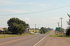
Looking east on Oklahoma State Highway 152
|
|

|
|
| Country | United States |
| State | Oklahoma |
| County | Beckham, Roger Mills |
| Area | |
| • Total | 15.87 sq mi (41.11 km2) |
| • Land | 15.86 sq mi (41.07 km2) |
| • Water | 0.02 sq mi (0.04 km2) |
| Elevation | 2,172 ft (662 m) |
| Population
(2020)
|
|
| • Total | 102 |
| • Density | 6.43/sq mi (2.48/km2) |
| Time zone | UTC-6 (Central (CST)) |
| • Summer (DST) | UTC-5 (CDT) |
| ZIP codes |
73666
|
| FIPS code | 40-71900 |
| GNIS feature ID | 2413357 |
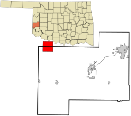
Sweetwater is a small town located in the state of Oklahoma, in the United States. It's special because it sits across two different counties: Beckham County and Roger Mills County. The town became an official town, or "incorporated," in 1998. In 2020, about 102 people lived there, which was a bit more than the 87 people counted in 2010.
Contents
A Look Back at Sweetwater's History
Sweetwater got its name from a nearby stream called Sweetwater Creek. The town is located where two main roads, State Highway 30 and State Highway 152, meet.
How Sweetwater Started
The town of Sweetwater began around 1892, when land in the Cheyenne-Arapaho area was opened for people to settle. A post office was set up in Sweetwater on September 27, 1894. Today, its ZIP code is 73666.
Early Growth and Challenges
By 1910, Sweetwater had about 50 people. It had two general stores, a store that sold dry goods and groceries, a cotton gin (a machine that separates cotton fibers), and a fuel company. People in Sweetwater hoped a railroad would be built through the area. A railroad would have helped the town grow much faster by making it easier to transport goods and people. However, no railroad was ever built, which limited how much the town could expand.
Changes Over Time
Around the time of World War I, Sweetwater's population grew to about 100 people. It became a center for farming services in the area. In the 1930s, the postmaster thought there were about 150 residents. But even before World War II, the population started to shrink. This happened because roads got better and more people had cars. It became easier for residents to travel to bigger towns like Erick or Elk City for shopping and business.
The 2007 Tornado
On May 5, 2007, a strong tornado hit the area around Sweetwater. This tornado was rated EF3 on the enhanced Fujita scale. An EF3 tornado has very strong winds, ranging from about 136 to 165 miles per hour. The tornado was about 100 to 150 yards wide and traveled for about 7.5 miles. It started south of Sweetwater and moved north, following State Highway 30. The tornado caused a lot of damage in the town. It severely damaged several buildings, including the church and the high school, and completely destroyed eight homes.
Learning in Sweetwater
The Sweetwater Public School District is the school system that serves the town. It is one of the smallest public school districts in all of Oklahoma.
- In 2007, Sweetwater High School had only 15 students, tying with another town called Boley for the smallest high school.
- For the entire school district, from kindergarten to 12th grade, Sweetwater had 60 students. This made it the third smallest combined district in Oklahoma, after Boley (51 students) and Clarita (58 students).
Getting Around Sweetwater
Sweetwater is located at an important crossroads for travelers.
- Oklahoma State Highway 6 and State Highway 152 both run through the town from east to west.
- Oklahoma State Highway 30 runs through the town from north to south.
- The border with the state of Texas is just a short distance to the west of Sweetwater.
Nearby Airports
- The Hobart Regional Airport (which has the code HBR) is about 74 miles southeast of Sweetwater. It has two paved runways, with the longest one being 5,507 feet long and 100 feet wide.
- For major flights with commercial airlines, the closest large airport is Rick Husband Amarillo International Airport. This airport is about 125 miles to the west of Sweetwater.
See also
 In Spanish: Sweetwater (Oklahoma) para niños
 | George Robert Carruthers |
 | Patricia Bath |
 | Jan Ernst Matzeliger |
 | Alexander Miles |

