Roger Mills County, Oklahoma facts for kids
Quick facts for kids
Roger Mills County
|
|
|---|---|

|
|

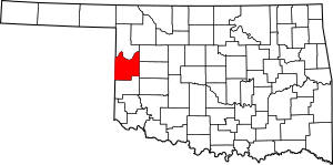
Location within the U.S. state of Oklahoma
|
|
 Oklahoma's location within the U.S. |
|
| Country | |
| State | |
| Founded | 1891 |
| Named for | Roger Q. Mills |
| Seat | Cheyenne |
| Largest town | Cheyenne |
| Area | |
| • Total | 1,146 sq mi (2,970 km2) |
| • Land | 1,141 sq mi (2,960 km2) |
| • Water | 5.3 sq mi (14 km2) 0.40%% |
| Population
(2020)
|
|
| • Total | 3,442 |
| • Density | 3.0035/sq mi (1.1597/km2) |
| Time zone | UTC−6 (Central) |
| • Summer (DST) | UTC−5 (CDT) |
| Congressional district | 3rd |
Roger Mills County is a county located in the western part of Oklahoma, a state in the United States. In 2020, about 3,442 people lived here. This makes it one of the counties with the fewest people in Oklahoma. The main town, or county seat, is Cheyenne. The county was started in 1891.
Roger Mills County sits on top of the Panhandle-Hugoton Field. This area is rich in oil, natural gas, and helium. The county also has part of the Ogallala Aquifer underneath it, which is a huge underground water source.
Contents
History of Roger Mills County
Roger Mills County is named after Roger Q. Mills. He was an officer in the Confederate Army during the American Civil War. Later, he became a senator for Texas.
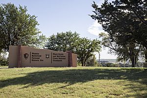
The town of Cheyenne in Roger Mills County is famous for the Battle of Washita River. This battle happened on November 26, 1868. During this event, George Armstrong Custer and his 7th U.S. Cavalry attacked a Cheyenne village. This village was led by Chief Black Kettle and was located along the Washita River.
Before it became Roger Mills County, this area was part of the Cheyenne Arapaho reservation. After Oklahoma Territory was created, it was first called County E. Later, it became Day County. When Oklahoma became a state on November 16, 1907, Day County was removed, and Roger Mills County was created. The western border of the county with Texas was later moved a bit east. This happened after the Supreme Court decided the 100th Meridian was actually further east than people first thought.
In the 1970s, Roger Mills County became very important for natural gas and oil production. It is part of the Panhandle-Hugoton Field. This is the largest gas field in the United States and the world's biggest source of helium. Between 1973 and 1993, this field produced a huge amount of gas.
Geography of Roger Mills County
Roger Mills County covers about 1,146 square miles. Most of this area, about 1,141 square miles, is land. Only a small part, about 5.3 square miles, is water. The Canadian River forms the northern edge of the county. The Washita River flows through the county from west to east, passing by Cheyenne and Strong City. The historic Antelope Hills are in the northeastern part of the county.
Main Roads in Roger Mills County
Neighboring Counties
- Ellis County (north)
- Dewey County (northeast)
- Custer County (east)
- Beckham County (south)
- Wheeler County, Texas (southwest)
- Hemphill County, Texas (northwest)
Protected Natural Areas
- Antelope Hills
- Black Kettle National Grassland (part of it)
- Break O'Day Farm
- Washita Battlefield National Historic Site
People of Roger Mills County
| Historical population | |||
|---|---|---|---|
| Census | Pop. | %± | |
| 1900 | 6,190 | — | |
| 1910 | 12,861 | 107.8% | |
| 1920 | 10,638 | −17.3% | |
| 1930 | 14,744 | 38.6% | |
| 1940 | 10,736 | −27.2% | |
| 1950 | 7,395 | −31.1% | |
| 1960 | 5,090 | −31.2% | |
| 1970 | 4,452 | −12.5% | |
| 1980 | 4,799 | 7.8% | |
| 1990 | 4,147 | −13.6% | |
| 2000 | 3,436 | −17.1% | |
| 2010 | 3,647 | 6.1% | |
| 2020 | 3,442 | −5.6% | |
| U.S. Decennial Census 1790-1960 1900-1990 1990-2000 2010 |
|||
In 2000, there were 3,436 people living in Roger Mills County. There were 1,428 households, and 988 families. The county had about 1 person per square mile. Most people living in the county were White (91.76%). There were also Native American people (5.47%) and people of other backgrounds. About 2.65% of the population was Hispanic or Latino.
About 29.40% of households had children under 18 living with them. Most households (58.80%) were married couples living together. The average household had 2.38 people.
The population was spread out by age. About 23.80% were under 18 years old. The median age was 42 years. This means half the people were younger than 42, and half were older.
In 2000, the average income for a household in the county was $30,078. For families, the average income was $35,921. About 16.30% of all people in the county lived below the poverty line. This included 20.40% of those under 18.
Economy of Roger Mills County
The economy of Roger Mills County has always relied on farming. This is helped by the fact that the county is above the Ogallala Aquifer, which provides water. Important crops grown here include Kaffir corn, broomcorn, wheat, cotton, corn, and alfalfa. Over the years, farms have become larger. In 1930, there were 2,353 farms, each about 278.3 acres. By 2000, there were only 680 farms, but each one was much bigger, averaging 1,015.54 acres.
Finding oil and natural gas in the Panhandle-Hugoton Field has also become a very important part of the county's economy.
In 2010, Roger Mills County had a high average income per person, which was $28,427. This was higher than the national average for the United States. It was the only county in Oklahoma where the average income per person was higher than the national average.
Towns and Communities
Towns
- Cheyenne (the county seat)
- Hammon (a small part is in Custer County)
- Reydon
- Strong City
- Sweetwater (part of it is in Beckham County)
Unincorporated Communities
Education in Roger Mills County
Here are some of the school districts that serve Roger Mills County:
- Cheyenne Public Schools
- Elk City Public Schools
- Hammon Public Schools
- Leedey Public Schools
- Merritt Public Schools
- Reydon Public Schools
- Sayre Public Schools
- Sweetwater Public Schools
Images for kids
See also
 In Spanish: Condado de Roger Mills para niños
 | Kyle Baker |
 | Joseph Yoakum |
 | Laura Wheeler Waring |
 | Henry Ossawa Tanner |


