Washita Battlefield National Historic Site facts for kids
|
Washita Battlefield
|
|

Washita Battlefield
|
|
| Nearest city | Cheyenne, Oklahoma |
|---|---|
| Area | 7,680 acres (12.00 sq mi; 31.1 km2) |
| Website | Washita Battlefield National Historic Site |
| NRHP reference No. | 66000633 |
Quick facts for kids Significant dates |
|
| Added to NRHP | October 15, 1966 |
| Designated NHL | January 12, 1965 |
The Washita Battlefield National Historic Site is a special place in Oklahoma. It helps us remember and understand an important event in American history. This site protects the area where a Southern Cheyenne village, led by Chief Black Kettle, once stood. It was here that the Battle of Washita happened.
The site is located near Cheyenne, Oklahoma, about 150 miles (240 km) west of Oklahoma City. Early in the morning on November 27, 1868, the village was attacked. Soldiers from the 7th U.S. Cavalry, led by Lt. Col. George Custer, carried out the attack. During the Battle of Washita, many Cheyenne people were hurt or killed.
At the time, some people saw this attack as a victory. They believed it would help stop raids on frontier settlements. It also forced the Cheyenne people back to their assigned lands. This historic site is part of a larger area. It was recognized as a National Historic Landmark in 1965. It was then added to the National Register of Historic Places in 1966. The full battlefield stretches for about 6 miles (9.7 km) through the city of Cheyenne.
| Washita Battlefield National Historic Site | |
|---|---|
| Established | November 12, 1996 |
| Visitors | 14,215 (in 2004) |
Contents
Exploring the Historic Site
The Washita Battlefield National Historic Site is a few miles west of Cheyenne, Oklahoma. You can find it on the north side of Oklahoma State Highway 47. The main part of the site is between SR 47A and the Washita River.
Visitor Center and Trails
The visitor center is located near where Highway 47 and 47A meet. Here, you can learn a lot about the battle. There are exhibits about the soldiers and the Cheyenne people. You can also watch a film and find books in the bookstore. Trails lead from the parking area on 47A through the park. These trails let you explore the historic land.
What the Site Looks Like
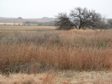
The site is mostly open prairie, which means it's a large grassy area. Along the river, you'll see strips of trees. It is completely surrounded by the Black Kettle National Grassland. This area is a protected natural space.
Protecting History
The historic site covers a special part of the 1868 battlefield. It includes one of the largest and best-preserved sections. This area was once the Cheyenne village, which was central to the battle. Other parts of the battlefield extend into Cheyenne. Some of these areas have changed over time due to roads and railroads. The site helps protect this important piece of history for everyone to learn from.
See also
 | Dorothy Vaughan |
 | Charles Henry Turner |
 | Hildrus Poindexter |
 | Henry Cecil McBay |


