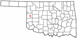
Strong City, Oklahoma facts for kids
Quick facts for kids
Strong City, Oklahoma
|
|
|---|---|

Location of Strong City, Oklahoma
|
|
| Country | United States |
| State | Oklahoma |
| County | Roger Mills |
| Area | |
| • Total | 0.50 sq mi (1.29 km2) |
| • Land | 0.50 sq mi (1.29 km2) |
| • Water | 0.00 sq mi (0.00 km2) |
| Elevation | 1,896 ft (578 m) |
| Population
(2020)
|
|
| • Total | 33 |
| • Density | 66.27/sq mi (25.58/km2) |
| Time zone | UTC-6 (Central (CST)) |
| • Summer (DST) | UTC-5 (CDT) |
| ZIP code |
73628
|
| Area code(s) | 580 |
| FIPS code | 40-70950 |
| GNIS feature ID | 2413344 |
Strong City is a small town in Roger Mills County, Oklahoma, in the United States. In 2020, a count of the population showed that 33 people lived there.
History of Strong City
Strong City officially became a town on June 25, 1912. It was named after Clint Strong, who was a railroad official and helped set up the town.
At first, Cheyenne, Oklahoma was chosen as the main town (the county seat) for Roger Mills County. But in August 1912, the nearest railroad, the Clinton and Oklahoma Western Railway, ended its tracks right in Strong City. This was a big deal because Strong City was planned with a rocky hill in the middle, saved for a courthouse if it became the county seat instead of Cheyenne. Within a year of the railroad arriving, Strong City grew to be bigger than Cheyenne and other towns in the county.
To keep its important position, the people of Cheyenne built their own short railroad line to connect to Strong City's railway. In 1914, the courthouse in Cheyenne burned down. People in Cheyenne worried that Strong City would try to get the new courthouse built there. But Cheyenne found the money and built a new brick courthouse in their town.
Strong City still tried to compete. In 1932, a state highway (Oklahoma State Highway 33) was built through Strong City, going north of Cheyenne. However, when the railroad was extended from Strong City to Cheyenne and then into Texas, trade started to move away from Strong City. The 1930s were tough for the town. Many businesses moved from Strong City to Cheyenne in 1934 and 1935. This caused Strong City to lose people and businesses, while Cheyenne grew. Today, Strong City is much smaller, and Cheyenne remains the county seat.
Geography and Location
Strong City covers an area of about 0.5 square miles (1.29 square kilometers), and all of it is land.
The town is located along State Highway 33. It is in the southwestern part of Oklahoma, an area known as Great Plains Country for tourism. Strong City is mostly surrounded by the Black Kettle National Grassland. The Black Kettle Recreation Area and a nearby lake are about 10 miles northwest. The Washita Battlefield National Historic Site, an important historical place, is about 11 miles southwest.
Population Changes
| Historical population | |||
|---|---|---|---|
| Census | Pop. | %± | |
| 1920 | 350 | — | |
| 1930 | 353 | 0.9% | |
| 1940 | 245 | −30.6% | |
| 1950 | 107 | −56.3% | |
| 1960 | 51 | −52.3% | |
| 1970 | 40 | −21.6% | |
| 1980 | 56 | 40.0% | |
| 1990 | 49 | −12.5% | |
| 2000 | 42 | −14.3% | |
| 2010 | 47 | 11.9% | |
| 2020 | 33 | −29.8% | |
| U.S. Decennial Census | |||
The population of Strong City has changed a lot over the years. In 1920, there were 350 people, and the population stayed similar in 1930. However, it started to decrease after that. By 1960, only 51 people lived there. In 2000, there were 42 people, and by 2020, the population was 33.
In 2000, the average age in Strong City was 42 years old. About 21% of the people were under 18, and about 28% were 65 or older.
Education
Students in Strong City attend schools that are part of the Cheyenne Public Schools district.
See also
 In Spanish: Strong City (Oklahoma) para niños
 | Selma Burke |
 | Pauline Powell Burns |
 | Frederick J. Brown |
 | Robert Blackburn |

