Ellis County, Oklahoma facts for kids
Quick facts for kids
Ellis County
|
|
|---|---|

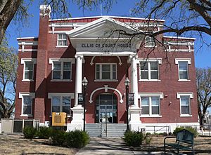
Ellis County Courthouse in Arnett
|
|

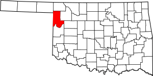
Location within the U.S. state of Oklahoma
|
|
 Oklahoma's location within the U.S. |
|
| Country | |
| State | |
| Founded | 1907 |
| Named for | Albert H. Ellis |
| Seat | Arnett |
| Largest town | Shattuck |
| Area | |
| • Total | 1,232 sq mi (3,190 km2) |
| • Land | 1,232 sq mi (3,190 km2) |
| • Water | 0.4 sq mi (1 km2) 0.03%% |
| Population
(2020)
|
|
| • Total | 3,749 |
| • Density | 3.0430/sq mi (1.1749/km2) |
| Time zone | UTC−6 (Central) |
| • Summer (DST) | UTC−5 (CDT) |
| Congressional district | 3rd |
Ellis County is a county located in the western part of Oklahoma. It's right on the border with Texas. In 2020, about 3,749 people lived here. This makes it one of the least populated counties in Oklahoma. The main town, or county seat, where the county government is, is Arnett.
The county got its name from Albert H. Ellis. He was an important person at the meeting in 1906 that helped create Oklahoma's laws.
Contents
History of Ellis County
This area was once home to many different Native American tribes. These included the Comanche, Kiowa, Apache, Cheyenne, and Arapaho.
In 1820, an explorer named Stephen Long traveled through this land. He was exploring the Canadian River. Later, conflicts started between Native Americans and white settlers. These settlers were quickly moving into Texas.
In 1858, a group of Texas Rangers and their Native American allies fought a battle here. It was called the Battle of Little Robe Creek. A famous Comanche chief, Iron Jacket, was killed in this battle. He was the father of Peta Nocona and grandfather of Quanah Parker.
Transportation and Growth
After the American Civil War, roads and railroads became very important. The Ellis County area became a busy pathway for travel. A military road connected Fort Supply (Oklahoma) to Fort Elliott.
In the 1880s, a cattle trail called the Western Trail crossed the military road. This was near where the town of Fargo is today. It was used to move cattle from Texas to Kansas.
Railroads also arrived, bringing new towns. The Southern Kansas Railway built a line in 1886-1887. This led to the creation of three towns in Ellis County: Fargo, Gage, and Shattuck.
Forming Ellis County
When Oklahoma Territory was first set up, this area was part of Day County. But after Oklahoma became a state, county borders changed. Day County was removed.
The northern part of Day County became Roger Mills County. The rest of Day County, plus a piece of Woodward County, became Ellis County. In June 1908, people voted for the county seat. Arnett won against Shattuck and became the county seat. It still is today.
The 1947 Tornado
On April 9, 1947, a very powerful tornado hit Ellis County. It was one of the deadliest tornadoes ever recorded in the United States. The tornado traveled for a very long distance. Most of the damage happened in the countryside. The towns were mostly safe. Six people in Ellis County lost their lives because of this storm.
Geography of Ellis County
Ellis County covers about 1,232 square miles (3,191 square kilometers) of land. Only a tiny bit, about 0.4 square miles, is water. Most of the county is part of the Great Plains, which are wide, flat grasslands.
The main stream here is Wolf Creek. It flows into the North Canadian River. Other smaller creeks also flow through the county. The Canadian River forms the southern border of Ellis County.
There are also important wildlife areas. The Ellis County Wildlife Management Area has Lake Lloyd Vincent. The Packsaddle Wildlife Management Area is also in the county. These areas help protect nature and provide places for outdoor activities.
Major Roads
 U.S. Highway 60
 U.S. Highway 270
 U.S. Highway 283
 U.S. Highway 412
 State Highway 3
 State Highway 15
 State Highway 46
 State Highway 51
Neighboring Counties
- Harper County (north)
- Woodward County (east)
- Dewey County (southeast)
- Roger Mills County (south)
- Hemphill County, Texas (southwest)
- Lipscomb County, Texas (west)
- Beaver County (northwest)
People of Ellis County (Demographics)
| Historical population | |||
|---|---|---|---|
| Census | Pop. | %± | |
| 1910 | 15,375 | — | |
| 1920 | 11,673 | −24.1% | |
| 1930 | 10,541 | −9.7% | |
| 1940 | 8,466 | −19.7% | |
| 1950 | 7,326 | −13.5% | |
| 1960 | 5,427 | −25.9% | |
| 1970 | 5,129 | −5.5% | |
| 1980 | 5,596 | 9.1% | |
| 1990 | 4,497 | −19.6% | |
| 2000 | 4,075 | −9.4% | |
| 2010 | 4,151 | 1.9% | |
| 2020 | 3,749 | −9.7% | |
| U.S. Decennial Census 1790-1960 1900-1990 1990-2000 2010 |
|||
In 2000, there were 4,075 people living in Ellis County. Most people were White (96.29%). About 1.20% were Native American. A small number of people were from other backgrounds. Most people spoke English at home.
The average age in the county was 45 years old. About 21.80% of the people were under 18 years old. About 22.00% were 65 years or older.
Economy of Ellis County
Since it was founded, Ellis County's economy has been based on farming and ranching. Farmers mainly grow wheat, cotton, and broomcorn. In 1907, the town of Shattuck was a major shipping point for broomcorn.
Raising cattle has also been important since the time after the Civil War. Even though some land rules changed, ranching and feeding cattle remained a big part of the economy. In the 1970s, dairy farming also became profitable here.
Education in Ellis County
Gage Public Schools are located in Ellis County. You can find more information on their website.
Recreation in Ellis County
The Ellis County Wildlife Management Area is a large area for public enjoyment. It covers about 4,800 acres (1,942 hectares). Here, people can enjoy wildlife and hunting.
In 1961, the Oklahoma Department of Wildlife Conservation created Lake Lloyd Vincent. This lake is about 160 acres (65 hectares) and is great for boating, fishing, and swimming.
Communities in Ellis County
Towns
Unincorporated Communities
See also
 In Spanish: Condado de Ellis (Oklahoma) para niños
 | James Van Der Zee |
 | Alma Thomas |
 | Ellis Wilson |
 | Margaret Taylor-Burroughs |


