Fargo, Oklahoma facts for kids
Quick facts for kids
Fargo, Oklahoma
|
|
|---|---|

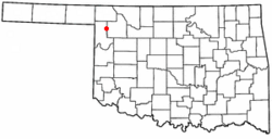
Location of Fargo, Oklahoma
|
|
| Country | United States |
| State | Oklahoma |
| County | Ellis |
| Area | |
| • Total | 0.58 sq mi (1.51 km2) |
| • Land | 0.58 sq mi (1.51 km2) |
| • Water | 0.00 sq mi (0.00 km2) |
| Elevation | 2,113 ft (644 m) |
| Population
(2020)
|
|
| • Total | 312 |
| • Density | 535.16/sq mi (206.74/km2) |
| Time zone | UTC-6 (Central (CST)) |
| • Summer (DST) | UTC-5 (CDT) |
| ZIP code |
73840
|
| Area code(s) | 580 |
| FIPS code | 40-25450 |
| GNIS feature ID | 2412621 |
Fargo is a small town located in Ellis County, Oklahoma, in the United States. In 2020, about 312 people lived there. Like many towns in its area, Fargo faced tough times during the Dust Bowl years and has been recovering since.
Contents
History of Fargo
Early Days and Railroad
In 1887, a railway company called the Southern Kansas Railway built train tracks through this area. This company was part of the Atchison, Topeka and Santa Fe Railway. The new tracks helped connect the region.
Land Run and Town Naming
The land around Fargo was opened for settlement in 1893 during the Cherokee Outlet Opening. This was a time when people could claim land in Oklahoma.
A man named David C. Ooley claimed land near Boggy Creek. He opened a general store there. Later, he bought more land along the railroad. He built a second store and got a post office named Whitehead in October 1893. The post office name changed to Oleta in August 1901. Finally, it became Fargo in February 1905.
Becoming a Town
When Oklahoma officially became a state in 1907, Fargo was made an incorporated town. At that time, about 436 people lived there. In 1909, a big fire destroyed many buildings on Main Street.
Geography of Fargo
Fargo is located in western Oklahoma. It is northeast of Gage and southwest of Woodward. You can find it just off Oklahoma State Highway 15.
The West Woodward Airport is about 9 miles northeast of Fargo. This airport helps connect the town to other places.
According to the United States Census Bureau, Fargo covers about 0.6 square miles (1.51 square kilometers). All of this area is land.
Population Changes
Fargo's population has changed over the years. Here's how many people have lived in the town during different census years:
| Historical population | |||
|---|---|---|---|
| Census | Pop. | %± | |
| 1910 | 341 | — | |
| 1920 | 258 | −24.3% | |
| 1930 | 325 | 26.0% | |
| 1940 | 291 | −10.5% | |
| 1950 | 318 | 9.3% | |
| 1960 | 291 | −8.5% | |
| 1970 | 262 | −10.0% | |
| 1980 | 409 | 56.1% | |
| 1990 | 299 | −26.9% | |
| 2000 | 326 | 9.0% | |
| 2010 | 364 | 11.7% | |
| 2020 | 312 | −14.3% | |
| U.S. Decennial Census | |||
In 2000, there were 326 people living in Fargo. About 31.3% of the population was under 18 years old. The average age of people in Fargo was 35 years.
Education in Fargo
In the summer of 2016, the schools in Fargo joined with the schools in Gage. This means students from Fargo now attend Gage Public Schools.
Fun Things to Do in Fargo
Local Attractions
Fargo has a nice city park. It features a working windmill and a water tank. There is also a playground for kids to enjoy. You can walk across a covered bridge in the park too.
Nearby Nature
Fort Supply Lake is located north and northeast of town. It's a great place for outdoor activities like fishing or boating.
Historic Building
The Stock Exchange Bank building on Main Street is a special place. It is listed on the National Register of Historic Places listings in Ellis County, Oklahoma. This means it's an important historical building.
Wind Energy Around Fargo
Fargo is in an area with strong winds. Because of this, there are large wind farms nearby that produce clean energy.
- OU Spirit Windfarm: Also known as Keenan I, this wind farm is southeast of Fargo. It can produce 101 megawatts of power.
- Keenan II Windfarm: This wind farm is also southeast of Fargo. It is even larger, with a capacity of 152 megawatts.
These wind farms help provide electricity using the power of the wind.
See also
 In Spanish: Fargo (Oklahoma) para niños

