Harper County, Oklahoma facts for kids
Quick facts for kids
Harper County
|
|
|---|---|

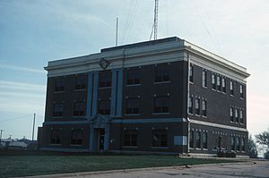
Harper County Courthouse in Buffalo (2007)
|
|

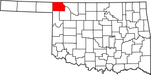
Location within the U.S. state of Oklahoma
|
|
 Oklahoma's location within the U.S. |
|
| Country | |
| State | |
| Founded | 1907 |
| Seat | Buffalo |
| Largest town | Laverne |
| Area | |
| • Total | 1,041 sq mi (2,700 km2) |
| • Land | 1,039 sq mi (2,690 km2) |
| • Water | 2.0 sq mi (5 km2) 0.2%% |
| Population
(2020)
|
|
| • Total | 3,272 |
| • Density | 3.1431/sq mi (1.2136/km2) |
| Time zone | UTC−6 (Central) |
| • Summer (DST) | UTC−5 (CDT) |
| Congressional district | 3rd |
Harper County is a county in the state of Oklahoma. In 2020, about 3,272 people lived here. This makes it one of the smallest counties in Oklahoma by population. The main town, or county seat, is Buffalo. Harper County was formed in 1907. It was named after Oscar Green Harper. He was a clerk for the group that wrote Oklahoma's constitution.
Contents
History of Harper County
Early Days and Formation
In the late 1800s, the land that is now Harper County was part of the Cherokee Outlet. This area was set aside for the Cherokee Nation by special agreements. But in 1893, the U.S. government allowed other people to settle there. After Oklahoma became a state, the land was divided into counties. Harper County was officially created in 1907. It got its name from Oscar Green Harper. He was a local teacher and helped write the Oklahoma state constitution.
Old Trails and Travel
Many important trails crossed this area in the 1800s. One was the Fort Dodge to Camp Supply Military Trail. The U.S. Army used it in 1868. They moved soldiers and supplies to build Camp Supply. This camp later became the town of Fort Supply, Oklahoma.
Another big trail was the Great Western Trail. It was also called the Dodge City Trail. People first used it in 1874 to move cattle from South Texas to Nebraska. In 1908, a company built a bridge over the Cimarron River. This made it easier to travel between Englewood, Kansas and Oklahoma.
County Seat and Ghost Towns
In 1908, people in Harper County voted to choose their county seat. The choices were Buffalo and Doby Springs. Buffalo won the election. Doby Springs later became a "ghost town," meaning people moved away. Today, it is a park in Buffalo. Other ghost towns in the county include Paruna, Flat, Avis, Readout, Cross, Alto, Cupid, and Stockholm.
Railroads Arrive
Trains first came to Harper County in 1912. The Wichita Falls and Northwestern Railway built a line through towns like Dunlap, May, Laverne, and Rosston. Later, a local railroad called the Buffalo and Northwestern Railroad (B&NW) connected Buffalo to Waynoka. This happened between 1919 and 1920. The Atchison, Topeka and Santa Fe Railway bought the B&NW in 1920. The first train line was closed in 1970.
Geography
Harper County covers about 1,041 square miles. Most of this is land, about 1,039 square miles. Only a small part, about 2 square miles, is water. The county has two main rivers: the Cimarron River and the Beaver River.
Major Highways
 U.S. Highway 64
 U.S. Highway 183
 U.S. Highway 270
 U.S. Highway 283
 U.S. Highway 412
 State Highway 3
 State Highway 34
 State Highway 46
 State Highway 149
Neighboring Counties
Harper County shares borders with these other counties:
- Comanche County, Kansas (to the northeast)
- Woods County (to the east)
- Woodward County (to the southeast)
- Ellis County (to the south)
- Beaver County (to the west)
- Clark County, Kansas (to the northwest)
Population and People
| Historical population | |||
|---|---|---|---|
| Census | Pop. | %± | |
| 1910 | 8,189 | — | |
| 1920 | 7,623 | −6.9% | |
| 1930 | 7,761 | 1.8% | |
| 1940 | 6,454 | −16.8% | |
| 1950 | 5,777 | −10.5% | |
| 1960 | 5,956 | 3.1% | |
| 1970 | 5,151 | −13.5% | |
| 1980 | 4,715 | −8.5% | |
| 1990 | 4,063 | −13.8% | |
| 2000 | 3,562 | −12.3% | |
| 2010 | 3,685 | 3.5% | |
| 2020 | 3,272 | −11.2% | |
| U.S. Decennial Census 1790-1960 1900-1990 1990-2000 2010 |
|||
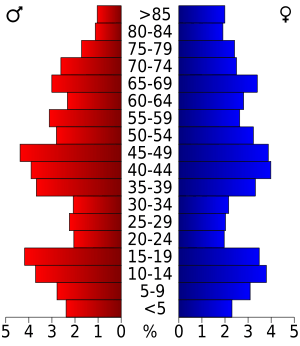
In 2000, there were 3,562 people living in Harper County. There were about 1,509 households. The population density was about 3 people per square mile. Most people in the county were White (about 95.87%). About 5.64% of the people were Hispanic or Latino.
The average age of people in the county was 43 years old. About 23.30% of the population was under 18 years old. About 21.70% of the people were 65 years or older.
Communities
Towns
Unincorporated Communities
These are smaller places that are not officially towns.
- Doby Springs (This is a ghost town)
- Selman (This is also a place recognized by the census)
See also
 In Spanish: Condado de Harper (Oklahoma) para niños
 | Bessie Coleman |
 | Spann Watson |
 | Jill E. Brown |
 | Sherman W. White |


